Valderøy
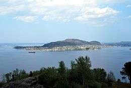 View of Valderøy island | |
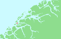 Location in Møre og Romsdal | |
| Geography | |
|---|---|
| Location | Giske Municipality, Norway |
| Coordinates | 62°29′50″N 06°07′08″E / 62.49722°N 6.11889°ECoordinates: 62°29′50″N 06°07′08″E / 62.49722°N 6.11889°E |
| Area | 6.5 km2 (2.5 sq mi) |
| Length | 4 km (2.5 mi) |
| Width | 2 km (1.2 mi) |
| Highest elevation | 231 m (758 ft) |
| Highest point | Signalen |
| Administration | |
| County | Møre og Romsdal |
| Municipality | Giske Municipality |
Valderøya is an island off the west coast of Norway. It is part of Giske Municipality in Møre og Romsdal county. The island is connected to the city of Ålesund to the south via the Valderøy Tunnel to the island of Ellingsøy and then by the Ellingsøy Tunnel to Ålesund. Valderøya is also connected to the island Vigra to the north by a short bridge. It is also connected to the island of Giske to the west by the Giske Bridge.
The municipal administration, a dentist, and a healthcare service centre for children are found in the municipal hall at Valderhaugstrand, a village on the south side of the island. Nordstrand and Oksnes are two another small villages on the north-east side of the island. On the south-west side are Skjong and Ytterland. There are also two primary schools, one lower secondary school, and Valderøy Church on Valderhaugstrand. The island is home to the fish processing industry and is home to many people who work in Ålesund. The local sports team is IL Valder.[1]
References
- ↑ Store norske leksikon. "Valderøy" (in Norwegian). Retrieved 2010-09-27.