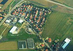
Vardon
| Vardon | |
|---|---|
 | |
 Vardon | |
| Coordinates: 31°39′47.16″N 34°46′49.44″E / 31.6631000°N 34.7804000°ECoordinates: 31°39′47.16″N 34°46′49.44″E / 31.6631000°N 34.7804000°E | |
| District | Southern |
| Council | Yoav |
| Affiliation | Kibbutz Movement |
| Founded | 1964 |
| Population (2015)[1] | 264 |
Vardon (Hebrew: ורדון) is a communal village in south-central Israel. Located north of Kiryat Gat and south of Kiryat Malakhi, it falls under the jurisdiction of Yoav Regional Council. In 2015 it had a population of 264.
History
It was founded in 1964 as a village center and became a communal village in 1998. The land had formerly belonged to the Arab village of Summeil, which was depopulated in the 1948 Arab–Israeli War.[2]
The name of the community is a loose translation for the family of Julius Rosenfeld who was a Jewish donor from the United States. ("Vardon" is derived from vered, which means "rose", hence Rosenfeld.
Education
Vardon, being a small community, has no schools, so it relies on schools of the Yoav Regional Council and the surrounding communities. The residents may go to either secular or religious schools. The elementary schools are "Sdot Yoav" in kibbutz Gat and "Yad Hazon" in Be'er Tuvia. High schools are "Tzafit" in Kfar Menahem and "Gruss" in Kiryat Gat.
Facilities
In Vardon there is a youth center, a sports field, public gardens, playgrounds, and a regional infirmary.
References
| Wikimedia Commons has media related to Vardon. |
- ↑ "List of localities, in Alphabetical order" (PDF). Israel Central Bureau of Statistics. Retrieved 16 October 2016.
- ↑ Khalidi, Walid (1992), All That Remains: The Palestinian Villages Occupied and Depopulated by Israel in 1948, Washington D.C.: Institute for Palestine Studies, p. 137, ISBN 0-88728-224-5