Varennes, Quebec
| Varennes | |||
|---|---|---|---|
| City | |||
|
| |||
| |||
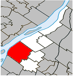 Location within Marguerite-D'Youville RCM. | |||
 Varennes Location in southern Quebec. | |||
| Coordinates: 45°41′N 73°26′W / 45.683°N 73.433°WCoordinates: 45°41′N 73°26′W / 45.683°N 73.433°W[1] | |||
| Country |
| ||
| Province |
| ||
| Region | Montérégie | ||
| RCM | Marguerite-D'Youville | ||
| Settled | 1672 | ||
| Constituted | August 26, 1972 | ||
| Government[2][3] | |||
| • Mayor | Martin Damphousse | ||
| • Federal riding | Pierre-Boucher—Les Patriotes—Verchères | ||
| • Prov. riding | Verchères | ||
| Area[2][4] | |||
| • Total | 114.40 km2 (44.17 sq mi) | ||
| • Land | 92.53 km2 (35.73 sq mi) | ||
| Elevation | 19 m (62 ft) | ||
| Population (2011)[4] | |||
| • Total | 20,994 | ||
| • Density | 226.9/km2 (588/sq mi) | ||
| • Pop 2006-2011 |
| ||
| • Dwellings | 8,001 | ||
| Time zone | EST (UTC−5) | ||
| • Summer (DST) | EDT (UTC−4) | ||
| Postal code(s) | J3X | ||
| Area code(s) | 450 and 579 | ||
| Highways |
| ||
| Website |
www | ||
Varennes is an off-island suburb of Montreal, in southwestern Quebec, Canada, on the Saint Lawrence River in the Marguerite-D'Youville Regional County Municipality. The city is approximately 24 kilometres (15 mi) from Downtown Montreal. The population as of the Canada 2011 Census was 20,994. In 2010, the population is listed at 21,174.
History
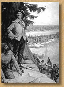
The history of Varennes[5] starts with the arrival of the Régiment de Carignan-Salières[6] in New France. René Gaultier,[7]sieur de Varennes, was given three concessions by intendant Jean Talon in 1672, le Tremblay, la Gabelle and Varennes.[8] Jaques-René,[9] one of his sons, was the second seigneur of Varennes. Five seignories later composed the Varennes parish. They were the seignories du Cap de Varennes, de l'île Sainte Thérese, de Grand Maison, du Cap de la trinité and du Cap Saint-Michel. The town was captured by the British during the Seven Years' War. It was part of Quebec then of Lower Canada before it returned to be part of Quebec again.
Varennes gained the status of city in 1972.
Demographics
Population
| Canada census – Varennes, Quebec community profile | |||
|---|---|---|---|
| 2011 | 2006 | 2001 | |
| Population: | 20,994 (+0.2% from 2006) | 20,950 (+6.6% from 2001) | 19,653 (+4.3% from 1996) |
| Land area: | 92.53 km2 (35.73 sq mi) | 92.53 km2 (35.73 sq mi) | 92.53 km2 (35.73 sq mi) |
| Population density: | 226.9/km2 (588/sq mi) | 226.4/km2 (586/sq mi) | 212.4/km2 (550/sq mi) |
| Median age: | 39.5 (M: 38.7, F: 40.2) | 37.2 (M: 36.8, F: 37.6) | 34.7 (M: 34.5, F: 35.0) |
| Total private dwellings: | 8,001 | 7,711 | 7,019 |
| Median household income: | $83,908 | $72,731 | $66,703 |
| References: 2011[4] 2006[10] 2001[11] | |||
| Historical Census Data - Varennes, Quebec[12] | ||||||||||||||||||||||||||
|---|---|---|---|---|---|---|---|---|---|---|---|---|---|---|---|---|---|---|---|---|---|---|---|---|---|---|
|
|
| ||||||||||||||||||||||||
Language
| Canada Census Mother Tongue - Varennes, Quebec[12] | ||||||||||||||||||
|---|---|---|---|---|---|---|---|---|---|---|---|---|---|---|---|---|---|---|
| Census | Total | French |
English |
French & English |
Other | |||||||||||||
| Year | Responses | Count | Trend | Pop % | Count | Trend | Pop % | Count | Trend | Pop % | Count | Trend | Pop % | |||||
| 2011 |
20,835 |
19,985 | |
95.92% | 360 | |
1.73% | 125 | |
0.60% | 365 | |
1.75% | |||||
| 2006 |
20,770 |
20,010 | |
96.34% | 305 | |
1.47% | 45 | |
0.22% | 410 | |
1.97% | |||||
| 2001 |
19,520 |
18,990 | |
97.28% | 375 | |
1.92% | 35 | |
0.18% | 120 | |
0.61% | |||||
| 1996 |
18,705 |
18,265 | n/a | 97.65% | 285 | n/a | 1.52% | 95 | n/a | 0.51% | 60 | n/a | 0.32% | |||||
Prominent citizens
See also
References
- ↑ Reference number 65025 of the Commission de toponymie du Québec (French)
- 1 2 Ministère des Affaires municipales, des Régions et de l'Occupation du territoire: Varennes
- ↑ Parliament of Canada Federal Riding History: VERCHÈRES--LES PATRIOTES (Quebec)
- 1 2 3 "2011 Community Profiles". Canada 2011 Census. Statistics Canada. July 5, 2013. Retrieved 2014-04-30.
- ↑ (French)Varennes: notes pour servir à l'histoire de cette seigneurie
- ↑ Régiment de Carignan-Salières In french on Wikipédia
- ↑ Biography of René Gaultier de Varennes in Dictionary of Canadian Biography Online, Library and Archives Canada
- ↑ (French)Toponymy page on the Varennes web site
- ↑ Biography of Jacques-René Gaultier de Varennes in Dictionary of Canadian Biography Online, Library and Archives Canada
- ↑ "2006 Community Profiles". Canada 2006 Census. Statistics Canada. March 30, 2011. Retrieved 2014-04-30.
- ↑ "2001 Community Profiles". Canada 2001 Census. Statistics Canada. February 17, 2012. Retrieved 2014-04-30.
- 1 2 Statistics Canada: 1996, 2001, 2006, 2011 census
External links
Photos
 |
Saint Lawrence River Repentigny |
Verchères | | |
| Saint Lawrence River Montreal |
|
Saint-Amable | ||
| ||||
| | ||||
| Boucherville | Sainte-Julie |
| Cities | |
|---|---|
| Municipalities | |
| Parishes | |
| |