Vashon Glaciation
| Vashon Glaciation | ||
| 19,000 - 16,000 BP | ||
| Vashon occurred at... | ||
| Continent: | North America | |
| Present-day country: | United States of America | |
| Present-day state: | Washington | |
| Region: | Western Washington | |
| Vashon Glaciation occurred within the... | ||
| Phanerozoic Eon | 541,000,000 BP - Present | |
| Cenozoic Era | 66,000,000 BP - Present | |
| Quaternary Period | 2,588,000 BP - Present | |
| Pleistocene Epoch | 2,588,000 - 11,700 BP | |
| Upper Pleistocene Age | 126,000 - 11,700 BP | |
| Vashon Glaciation was a part of the... | ||
| Quaternary glaciation | 2,588,000 BP to present | |
| Last glacial period | 110,000 - 12,000 BP | |
| Wisconsin glaciation | 85,000 - 11,000 BP | |
| Fraser glaciation | ||
| Vashon glaciation | 19,000 - 16,000 BP | |
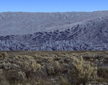
The Vashon Glaciation or Vashon Stade was the most recent period of very cold climate in which glaciers existed at elevations at and near sea level in the western part of present-day Washington State.[1] It occurred during a colder than present part of the current ice age.
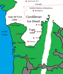
The Vashon Glaciation lasted from about 19,000 - 16,000 BP (Before Present - present defined as January 1, 1950 for this scale). The Cordilleran Ice Sheet was an ice sheet that covered present-day southern Alaska and parts of western Canada. During the Vashon Glaciation, the Cordilleran Ice Sheet advanced into the Puget Sound region.
Climate
Pollen data colected from Battle Ground Lake in the southern Puget Sound Region shows that from 20,000 - 16,000 BP, annual temperatures in the area were about 6 ± 1 °C (10.8 ± 1.8 °F) colder than in present times (present times as of 1990), and precipitation was around 1 meter (39.4 inches) less.[2] The Battle Ground area averaged 52.14 inches (132.44 cm) of precipitation per year for the period of 1961-1990.[3] A meter less precipiation means that during period of 20,000 - 16,000 BP, the average precipitation would have only been around 24.5% of what it was in the near present 1961-1990 period.
The Laurentide Ice Sheet had a major effect on the climate. It was an ice sheet covering much of Canada, and parts of the northern United States in the midwest and east. The Rocky Mountains separated the Laurentide Ice Sheet from the Cordilleran Ice Sheet. The Laurentide Ice Sheet had a cooling effect on the middle latitudes.[2] This caused the jet stream over North America to split in two.[2] The southern branch was pushed further south than it is in present times meaning that the storm tracks were missing the Pacific Northwest most of the time.[2] Because of this, Southern and Central California had wetter climates than in present times.[4]
| Average Annual Temperatures and Precipitation from 20,000 - 16,000 BP | ||||
| City/Location | Average Annual Temperature | Average Annual Precipitation | ||
|---|---|---|---|---|
| Aberdeen | 39.7 °F (4.3 °C) | 20.26 inches (51.46 cm) | ||
| Battleground | 40.2 °F (4.6 °C) | 12.77 inches (32.44 cm) | ||
| Centralia | 40.8 °F (4.9 °C) | 11.52 inches (29.26 cm) | ||
| Vancouver | 40.4 °F (4.7 °C) | 10.12 inches (25.69 cm) | ||
| Table is based on temperatures being 6 °C colder and precipiation only being 24.5% of what it was in the 1961-1990 period. Source for 1961-1990 averages: Western Regional Climate Data Center http://www.wrcc.dri.edu/summary/waF.html The locations listed are areas not covered by the glacier. Calculating climate on top of the glacier is more complicated due to the elevation difference and the effect that ice has on temperature. | ||||
Average annual temperatures in the lowlands of Western Washington were above 0 °C (32 °F). This means that there was more summer thawing than there was winter freezing. This would seem to be a climate too warm to support glaciers, but the ice was pushing in from the north faster than it could melt.
The advance
During the Vashon Glaciation, the Cordilleran Ice Sheet grew and advanced southwards at a rate of about 135 meters (440 feet) per year.[5][6] It crossed the present-day Canada–United States border around 19,000 BP.[6] This part of the Cordilleran Ice Sheet is called the Puget Lobe. The Vashon Glaciation actually began after the global glacial maximum. Glaciers were retreating throughout most of the world, but growing in Western Washington. Around 18,350 BP, the Puget Lobe blocked the Puget Sound from reaching the Strait of Juan de Fuca,[6] turning the Puget Sound into Glacial Lake Russell.[7] By around 17,950 BP, the glacier reached present-day Seattle.[6] By around 17,650 BP, the Puget Lobe reached present-day Tacoma.[6] By around 17,350 BP, the glacier reached present-day Olympia.[6] The Puget Lobe reached its maximum extent in the vicinity of the present-day city of Tenino[8] around 16,950 BP.[5]
The maximum extent
The Puget Lobe remained at its maximum extent in the vicinity of present-day Tenino from around 16,950 BP to around 16,850 BP, a total of about 100 years.[5] The ice depths were about 1.6 kilometers (1 mile) at the present-day Canada–United States border, 1,000 meters (3,300 feet) in Seattle, and 200 meters (650 feet) at the glacier's terminus in the Tenino area.[5]
The retreat
Around 16,850 BP, the Puget Lobe began retreating northward at a rate of about 340 meters (1,120 feet) per year.[5] By about 16,650 BP, the glacier only came down to present-day Olympia.[6] The Puget Lobe began to uncover Glacial Lake Russell. By 16,450 BP, the Puget Lobe only came down to Tacoma. By 16,150 BP, the glacier only came down to Seattle.[6] By about 16,000 BP, the Puget Lobe retreated far enough north that Glacial Lake Russell and the Straight of Juan de Fuca became connected, making Glacial Lake Russell the salt water body of Puget Sound again.[6]
Formation of Kettles and Kettle Lakes
For areas on land, as the Puget Lobe receded, blocks of ice broke off and became separate. The melting glacier produced streams which carried sediment. The bottom of the ice blocks became buried in sediment. As the blocks of ice melted, it left depressions in the ground called kettles. Some of these kettles filled up with water to become kettle lakes and kettle ponds. (see Kettle (landform))
Glacial Lake Carbon - Catastrophic Glacial Outburst Flood
Glacial Lake Carbon was a lake created by the Puget Lobe damming the Carbon River. Around 16,850 BP when the glacier began retreating, the ice dam holding back the lake became breached causing a major glacial outburst flood.[9] The flood covered present day central and northern Thurston County, part of Pierce County, and small parts of Lewis and Grays Harbor Counties.[10]
Life during the Vashon Glaciation
| Domain | Kingdom | Phylum / Division | Class | Order | Family | Genus & Species | Life Form Name (common) | Location & Time Period | Current Status |
|---|---|---|---|---|---|---|---|---|---|
| Eukaryota | Animalia | Chordata | Mammalia | Artiodactyla | Bovidae | Bison[11] | Bison | Genus no longer exists in Western Washington. | |
| Eukaryota | Animalia | Chordata | Mammalia | Artiodactyla | Bovidae | Ovibos moschatus[11] | Muskox | Species no longer exists in Western Washington. | |
| Eukaryota | Animalia | Chordata | Mammalia | Carnivora | Canidae | Canis lupis | Grey Wolf | Species no longer exists in Western Washington due hunting during the latter half of the 1800s century up until the 1930s.[12] | |
| Eukaryota | Animalia | Chordata | Mammalia | Carnivora | Felidae | Homotherium serum[13] | Scimitar-toothed cat | Species is extinct worldwide as well as the genus it belongs to. | |
| Eukaryota | Animalia | Chordata | Mammalia | Carnivora | Felidae | Panthera leo atrox[14] | American lion | Subspecies is extinct worldwide. | |
| Eukaryota | Animalia | Chordata | Mammalia | Carnivora | Felidae | Smilodon fatalis[15] | Saber-tooth cat | Species is extinct worldwide as well as the genus it belongs to. | |
| Eukaryota | Animalia | Chordata | Mammalia | Carnivora | Ursidae | Arctodus simus | Short-faced bear | Species is extinct worldwide as well as the genus it belongs to. | |
| Eukaryota | Animalia | Chordata | Mammalia | Proboscidea | Elephantidae | Mammuthus columbi[16] | Columbian mammoth | Species is extinct worldwide as well as the genus it belongs to. | |
| Eukaryota | Animalia | Chordata | Mammalia | Proboscidea | Mammutidae | Mammut americanum[11] | American mastodon | Species is extinct worldwide as well as the genus it belongs to. | |
| Eukaryota | Animalia | Chordata | Mammalia | Pilosa | Megalonychidae | Megalonyx jeffersonii[11] | Jefferson's Ground Sloth | Species is extinct worldwide as well as the genus it belongs to. | |
| Eukaryota | Animalia | Chordata | Mammalia | Rodentia | Geomyidae | Thomomys mazama melanops[17] | Mazama pocket gopher | Species does currently exist in this area, but not abundantly. | |
| Eukaryota | Plantae | Pinophyta | Pinopsida | Pinales | Pinaceae | Abies lasiocarpa[2] | Subalpine fir | Puget Sound Region, 21,000 - 17,000 BP | Species no longer grows in the Puget Sound Region as a native plant. |
| Eukaryota | Plantae | Pinophyta | Pinopsida | Pinales | Pinaceae | Picea[2] | Spruce | Olympic Peninsula - west side lowlands, 20,000 - 16,000 BP | Genus does currently grow in this area as a native plant. |
| Eukaryota | Plantae | Pinophyta | Pinopsida | Pinales | Pinaceae | Picea engelmannii[2] | Engelman spruce | Puget Sound Region, 21,000 - 17,000 BP | Species no longer grows in the Puget Sound Region as a native plant. |
| Eukaryota | Plantae | Pinophyta | Pinopsida | Pinales | Pinaceae | Pinus[2] | Pine | Olympic Peninsula - west side lowlands, 20,000 - 16,000 BP | Genus does currently grow in this area as a native plant. |
| Eukaryota | Plantae | Pinophyta | Pinopsida | Pinales | Pinaceae | Pinus contorta[2] | Lodgepole pine | Puget Sound Region, 21,000 - 17,000 BP | Species does currently grow in this area as a native plant. |
| Eukaryota | Plantae | Pinophyta | Pinopsida | Pinales | Pinaceae | Tsuga heterophylla[2] | Western hemlock | Olympic Peninsula - west side lowlands, 20,000 - 16,000 BP | Species does currently grow in this area as a native plant. |
| Eukaryota | Plantae | Pinophyta | Pinopsida | Pinales | Pinaceae | Tsuga mertensiana[2] | Mountain hemlock | Olympic Peninsula - west side lowlands, 20,000 - 16,000 BP | Species does currently grow in this area as a native plant. |
| Eukaryota | Plantae | Pinophyta | Pinopsida | Pinales | Taxaceae | Taxus brevifolia[2] | Pacific yew | Puget Sound Region, 21,000 - 17,000 BP | Species does currently grow in this area as a native plant. |
| Eukaryota | Plantae | N/A | N/A | Asterales | Asteraceae | Artemisia[2] | Sage brush | Puget Sound Region, 21,000 - 17,000 BP; Olympic Peninsula - west side near the alpine glaciers, 20,000 - 16,000 BP | Genus no longer grows in western Washington as a native plant. |
| Eukaryota | Plantae | N/A | N/A | Fagales | Betulaceae | Alnus[2] | Alder | Olympic Peninsula - west side lowlands, 20,000 - 16,000 BP | Genus does currently grow in this area as a native plant. |
| Eukaryota | Plantae | N/A | N/A | Poales | Cyperaceae[2] | Sedges | Puget Sound Region, 21,000 - 17,000 BP | Family does currently grow in this area as a native plant. | |
| Eukaryota | Plantae | N/A | N/A | Poales | Poaceae[2] | Grass | Puget Sound Region, 21,000 - 17,000 BP; Olympic Peninsula - west side near the alpine glaciers, 20,000 - 16,000 BP | Family does currently grow in this area as a native and non-native plant. | |
Humans
At this time, no scientific evidence has been found indicating that human beings were in the area during the Vashon Glaciation. The oldest known human artifacts in the area are from 13,800 BP.[18]
References
- ↑ http://www.historylink.org/index.cfm?DisplayPage=output.cfm&file_id=5087 Historylink.org - Jennifer Ott - Retreating glaciers create Puget Sound and Grand Coulee as the Ice Age ends about 15,000 years ago.
- 1 2 3 4 5 6 7 8 9 10 11 12 13 14 15 16 http://www.fs.fed.us/rm/pubs/rmrs_gtr292/1992_whitlock.pdf University of Washington – Cathy Whitlock - Vegetational and Climatic History of the Pacific Northwest during the Last 20,000 Years: Implications for Understanding Present-day Biodiversity
- ↑ http://www.wrcc.dri.edu/cgi-bin/cliMAIN.pl?wa0482 Western Regional Climate Data Center - Battleground
- ↑ http://geochange.er.usgs.gov/sw/impacts/biology/pastclim/ U.S. Geological Survey - Robert S. Thompson - Past Climate and Vegetation Changes in the Southwestern United States
- 1 2 3 4 5 http://faculty.washington.edu/tswanson/ESS/Research/QR%2098%20205-213.pdf University of Washington - Stephen C. Porter and Terry W. Swanson - Radiocarbon Age Constraints on Rates of Advance and Retreat of the Puget Lobe of the Cordilleran Ice Sheet during the Last Glaciation
- 1 2 3 4 5 6 7 8 9 https://www.youtube.com/watch?v=YHWMHzi_deg Vashon Glaciation Animation
- ↑ http://facweb.northseattle.edu/tfurutan/geology111/Puget%20Sound.pdf North Seattle Community College - The Glacial Origins of the Puget Basin
- ↑ http://www.dnr.wa.gov/programs-and-services/geology/explore-popular-geology/geologic-provinces-washington/puget-lowland WA State Dept. of Natural Resources - Puget Lowland
- ↑ http://soundideas.pugetsound.edu/faculty_pubs/2291/ University of Puget Sound - Sedimentologic Evidence For A Glacial Outburst Flood And Resulting Debris Flow; Puget Lowland, Washington State
- ↑ http://www.centralia.edu/academics/earthscience/pringle/pubs/Tanwax_NWSA_poster2010.pdf Centralia College - Tracking the Late-Glacial Outburst Flood from Glacial Lake Carbon, Washington State, USA
- 1 2 3 4 http://www.nwpaleo.org/Resources/WA_Geology/WA_Geol_1998-Sloth.html H. Gregory McDonald The Sloth, the President, and the Airport
- ↑ https://www.fws.gov/wafwo/Documents/GraywolvesinWashingtonfinalAugust2015.pdf U.S. Fish & Wildlife Service - Grey Wolves in Washington State - Questions and Answers
- ↑ http://prehistoric-fauna.com/Homotherium-serum Roman Uchytel - Prehistoric Fauna - Homotherium serum
- ↑ http://listverse.com/2010/12/02/10-huge-prehistoric-cats/ 10 Huge Prehistoric Cats
- ↑ https://bioweb.uwlax.edu/bio203/s2014/chang_sith/habitat.htm Smilodon fatalis BIO203
- ↑ http://depts.washington.edu/qrc/BRB1999WG.pdf University of Washington - Washington Geology - Dec 1999
- ↑ http://wdfw.wa.gov/publications/00390/wdfw00390.pdf Washington State Department of Fish and Wildlife - Status Report for the Mazama Pocket Gopher, Streaked Horned Lark, and Taylor's Checkerspot
- ↑ http://www.seattletimes.com/seattle-news/wsu-prof-was-right-mastodon-weapon-was-older-than-thought-scientists-say/ The Seattle Times - WSU prof was right: Mastodon weapon was older than thought, scientists say