Store Venjetinden
| Store Venjetinden | |
|---|---|
| Store Vengetinden | |
 Store Venjetinden seen from Breitinden | |
| Highest point | |
| Elevation | 1,852 m (6,076 ft) |
| Prominence | 710 m (2,330 ft) |
| Coordinates | 62°30′27″N 07°50′22″E / 62.50750°N 7.83944°ECoordinates: 62°30′27″N 07°50′22″E / 62.50750°N 7.83944°E |
| Geography | |
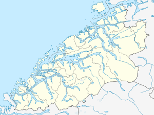 Store Venjetinden Location in Møre og Romsdal | |
| Location | Rauma, Møre og Romsdal, Norway |
| Parent range | Romsdalsalpene |
| Topo map | 1320 II Eresfjord |
| Climbing | |
| First ascent | 18 August 1881, north-east ridge, William Cecil Slingsby and Johannes Vigdal |
| Easiest route | Climbing |
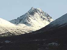
Seen from Isfjorden
Store Venjetinden (or sometimes Store Vengetinden) is a mountain in the municipality of Rauma in Møre og Romsdal county, Norway. It is located about 3 kilometres (1.9 mi) northeast of the mountain Romsdalshornet, about 4 kilometres (2.5 mi) east of the Rauma river and European Route E136, and about 10 kilometres (6.2 mi) southeast of the town of Åndalsnes.[1]
The first ascent was via the northeast ridge in 1881 by William Cecil Slingsby and Johannes Vigdal. The first ascent via the western ridge was in 1930 by Erik Heen and Karl Oshaug.[2]
References
- ↑ Store norske leksikon. "Vengetindane" (in Norwegian). Retrieved 2010-10-27.
- ↑ Nebell, Anne Grete; Bø, Bjarte (1999). Klatring i Romsdal (in Norwegian). Sogge Fjellsport. ISBN 978-82-995032-0-4.
External links
-
 Media related to Store Venjetinden at Wikimedia Commons
 - Pictures of the mountain
This article is issued from Wikipedia - version of the 5/28/2015. The text is available under the Creative Commons Attribution/Share Alike but additional terms may apply for the media files.