Villaluenga del Rosario
| Villaluenga del Rosario, Spain | |||
|---|---|---|---|
| |||
.png) Location of Villaluenga del Rosario | |||
| Coordinates: 36°42′N 5°23′W / 36.700°N 5.383°WCoordinates: 36°42′N 5°23′W / 36.700°N 5.383°W | |||
| Municipality | Cádiz | ||
| Government | |||
| • Mayor | Alfonso Carlos Moscoso | ||
| Area | |||
| • Total | 57 km2 (22 sq mi) | ||
| • Land | 57 km2 (22 sq mi) | ||
| • Water | 0.00 km2 (0.00 sq mi) | ||
| Population (2005) | |||
| • Total | 481 | ||
| • Density | 8.4/km2 (22/sq mi) | ||
| Time zone | CET (UTC+1) | ||
| • Summer (DST) | CEST (UTC+2) | ||
| Website | villaluengadelrosario.es | ||
Villaluenga del Rosario is a village located in the province of Cádiz, Spain. According to the 2005 census, the city has a population of 481 inhabitants.
It's located down Navazo Alto mountain, inside Sierra de Grazalema Natural Park.
Demographics
| Historical population | ||
|---|---|---|
| Year | Pop. | ±% |
| 1999 | 447 | — |
| 2000 | 440 | −1.6% |
| 2001 | 414 | −5.9% |
| 2002 | 455 | +9.9% |
| 2003 | 449 | −1.3% |
| 2004 | 473 | +5.3% |
| 2005 | 481 | +1.7% |
| Source: INE (Spain) | ||
Gallery
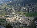 View of Villaluenga del Rosario when climbing to Navazo Alto
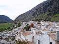 Villaluenga del Rosario
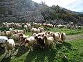 Sheep crossing a road
External links
| Wikimedia Commons has media related to Villaluenga del Rosario. |
- Villaluenga del Rosario - Sistema de Información Multiterritorial de Andalucía
This article is issued from Wikipedia - version of the 9/8/2016. The text is available under the Creative Commons Attribution/Share Alike but additional terms may apply for the media files.