Virginia State Route 272
| ||||
|---|---|---|---|---|
| South Quay Road | ||||
 | ||||
| Route information | ||||
| Maintained by VDOT | ||||
| Length: | 1.24 mi[1] (2.00 km) | |||
| Existed: | c. 1990 – present | |||
| Major junctions | ||||
| West end: |
| |||
| East end: |
| |||
| Location | ||||
| Counties: | City of Suffolk | |||
| Highway system | ||||
| ||||

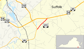
State Route 272 (SR 272) is a primary state highway in the U.S. state of Virginia. Known as South Quay Road, the state highway runs 1.24 miles (2.00 km) from SR 189 east to U.S. Route 58 (US 58) and SR 189 within the independent city of Suffolk. SR 272 is a cut-off of old alignment of SR 189.
Route description
SR 272 begins at SR 189 in a rural area of the city of Suffolk southeast of the city of Franklin. SR 189 heads southwest as South Quay Road and north as an unnamed highway toward Franklin. SR 272 heads northeast through a mix of farmland and forest to its eastern terminus at US 58 and SR 189, which run concurrently through much of Suffolk. The two highways head west as an unnamed highway toward Franklin and east as South Quay Road toward the center of Suffolk.[1][2]
Major intersections
The entire route is in Suffolk.
| mi[1] | km | Destinations | Notes | ||
|---|---|---|---|---|---|
| 0.00 | 0.00 | ||||
| 1.24 | 2.00 | ||||
| 1.000 mi = 1.609 km; 1.000 km = 0.621 mi | |||||
References
- 1 2 3 "2010 Traffic Data". Virginia Department of Transportation. 2010. Retrieved 2012-01-03.
- City of Suffolk (PDF)
- ↑ Google (2012-01-03). "Virginia State Route 272" (Map). Google Maps. Google. Retrieved 2012-01-03.