U.S. Route 58
| |||||||
|---|---|---|---|---|---|---|---|
 | |||||||
| Route information | |||||||
| Maintained by TDOT and VDOT | |||||||
| Length: | 508 mi[1] (818 km) | ||||||
| Existed: | 1931[1] – present | ||||||
| Major junctions | |||||||
| West end: |
| ||||||
|
| |||||||
| East end: |
| ||||||
| Location | |||||||
| States: | Tennessee, Virginia | ||||||
| Counties: |
TN: Claiborne VA: Lee, Scott, Washington, City of Bristol, Grayson, City of Galax, Carroll, Floyd, Patrick, Henry, Pittsylvania, City of Danville, Halifax, Mecklenburg, Brunswick, Greensville, City of Emporia, Southampton, City of Suffolk, City of Chesapeake, City of Portsmouth, City of Norfolk, City of Virginia Beach | ||||||
| Highway system | |||||||
| |||||||

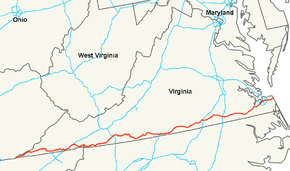
U.S. Route 58 is an east–west U.S. Highway that runs for 508 miles (818 km) from U.S. Route 25E just northwest of Harrogate, Tennessee, to U.S. Route 60 in Virginia Beach, Virginia. Until 1996, when the Cumberland Gap Tunnel opened, US 58 ran only inside the commonwealth of Virginia. It was then extended southwest along a short piece of former US 25E, which no longer enters Virginia, to end at the new alignment in Tennessee.
State Route 383 is overlaid on U.S. Route 58 in Tennessee.
U.S. Route 58 is the longest numbered route in Virginia.[2]
Route description
Tennessee
US 58 begins at a trumpet interchange with US 25E, just south of the Cumberland Gap Tunnel. The route travels northeast through the outskirts of Cumberland Gap before crossing into Virginia.
US 58 in Tennessee carries the designation State Route 383.
Virginia
US 58 enters Virginia and travels east to Jonesville, where Alternate US 58 branches off and travels to the north. East of Jonesville, US 58 intersects US 421, and the two routes stay concurrent through Duffield (where the concurrency also picks up U.S. 23), Gate City, Weber City (where the US 23 concurrency ends), and Bristol, where US 58 begins a concurrency with Interstate 81. The two routes stay concurrent until I-81 exit 19 in Abingdon, where US 58 resumes its eastward journey close to the Virginia–North Carolina state line. The route is signed as the J.E.B. Stuart Highway and the A. L. Philpott Memorial Highway. Much of the highway through the region features hairpin turns, steep grades, and load-zoned bridges.
US 58 begins a concurrency with US 221 in Independence, and the routes stay merged through Hillsville, just past the interchange with Interstate 77. Continuing eastward, the route crosses the Blue Ridge Parkway in the unincorporated community of Meadows of Dan before winding its way to Martinsville, where US 58 and US 220 share a southern bypass of the city.
Approaching Danville, US 58 once again follows an expressway bypass to the south of the city, while a business route enters the city itself. The southeastern half of this bypass is shared with US 29. East of Danville, US 29 continues north, while US 58 picks up US 360 (which begins in central Danville) and resumes its eastward journey. The routes stay cosigned until South Boston, where US 360 resumes a more northerly route to Richmond, while US 58 travels eastward to Clarksville and crosses Kerr Lake.
The route crosses US 1 and Interstate 85 in South Hill, followed by Interstate 95 in Emporia. Near Franklin, an expressway bypass carries US 58 (and, for one stretch, US 258) south of the city, while a business route enters the city. A bypass also carries traffic around Suffolk, where US 58 begins concurrencies with US 13 and then US 460. The three US routes stay merged until an intersection with the Hampton Roads Beltway at the confluence of Interstate 64, Interstate 264, and Interstate 664. US 58 travels inside the beltway and through Portsmouth and into Norfolk via the Midtown Tunnel. The route crosses I-64 once again, and continues to Virginia Beach, roughly paralleling I-264 to its south. US 58, designated as Virginia Beach Boulevard and becoming Laskin Rd. in Virginia Beach, ends at US 60, Pacific Ave. Historically, US 58 continued for one additional block to the east, ending at Atlantic Ave., which once carried US 60 and then Business US 60.[3]
Much of the western section of US 58 is part of The Crooked Road: Virginia's Heritage Music Trail.[4][5]
Alternate route
| |
|---|---|
| Location: | Jonesville–Abingdon |
| Length: | 87.40 mi[6] (140.66 km) |
| Existed: | early 1950s–present |
An alternate route of US 58, known as U.S. Route 58 Alternate (US 58 Alt.), splits from the main route in Abingdon, Virginia and travels northwest (signed west) as the "Trail of the Lonesome Pine" to Coeburn. From there, US 58 Alt. travels in a southwesterly direction (signed west) through Norton, Big Stone Gap and Pennington Gap before rejoining the main route in Jonesville.
History
The corridor across southern Virginia was part of the initial 1918 state highway system, in which it was State Route 12. It generally followed the present U.S. 58 from Abingdon to Virginia Beach, while present US 58 west of Abingdon was part of State Route 10. These routes deviated from present US 58 in the following places:[7][8][9]
- SR 10 left Virginia into Kentucky at Cumberland Gap; the piece of current US 58 into Tennessee was (in general terms) State Route 107 from 1923 to 1928 and State Route 100 from 1928 to 1933 (as well as U.S. Route 25E from 1926 to 1996).
- SR 10 used present U.S. Route 58 Alternate from Jonesville to Pennington Gap and U.S. 421 southeast back to U.S. 58.
- SR 10 used present State Route 638 and State Route 600 from near Pattonsville to Clinchport.
- SR 10 used present U.S. 421 and U.S. Route 11 through Bristol to Abingdon. From Abingdon to Meadowview, where SR 12 began, SR 10 used present State Route 609.
- SR 12 used present State Route 80 and State Route 803 from Meadowview to Lodi and roughly present State Route 91 to Damascus.
- From Danville to Boydton, SR 12 used present State Route 360 to near Scottsburg, U.S. Route 360 to Clover, and State Route 92 to Boydton. Present US 58 was State Route 44 (formed ca. 1930) from Danville to Clarksville, and from Clarksville to Boydton it was initially part of State Route 1, renumbered State Route 31 in the 1923 renumbering, State Route 324 from soon after 1923 to 1927, part of State Route 201 from 1927 to 1928,[10] and State Route 400 from 1928 to 1933.
- From Suffolk to Portsmouth, SR 12 used present State Route 337.
Major intersections
| State | County | Location | mi[6] | km | Destinations | Notes | ||
|---|---|---|---|---|---|---|---|---|
| Tennessee | Claiborne | | 0.0 | 0.0 | interchange | |||
| Cumberland Gap | Cumberland Gap | |||||||
| 0.6 0.00 | 0.97 0.00 | Tennessee–Virginia state line | ||||||
| Virginia | Lee | | ||||||
| | ||||||||
| | former SR 63 south | |||||||
| Jonesville | 33.36 | 53.69 | ||||||
| Dot | 42.51 | 68.41 | west end of US 421 overlap | |||||
| Scott | | former SR 66 north | ||||||
| Duffield | 53.26 | 85.71 | west end of US 23 overlap | |||||
| see US 23 (mile 20.85-2.92) | ||||||||
| Weber City | 71.19 | 114.57 | east end of US 23 overlap; west end of SR 224 overlap | |||||
| | 71.45 | 114.99 | east end of SR 224 overlap | |||||
| Hiltons | to former SR 42 east | |||||||
| Washington | | former SR 77 north | ||||||
| City of Bristol | 95.67 | 153.97 | east end of US 421 overlap; west end of I-81 overlap; US 58 west follows exit 1B | |||||
| see I-81 | ||||||||
| Washington | | 113.95 | 183.38 | east end of I-81 overlap; west end of US 11 overlap; US 58 east follows exit 19 | ||||
| | 114.25 | 183.87 | east end of US 11 overlap | |||||
| Damascus | to SR 133 (TN) | |||||||
| 124.73 | 200.73 | west end of SR 91 overlap | ||||||
| Laureldale | 125.72 | 202.33 | east end of SR 91 overlap | |||||
| | ||||||||
| | ||||||||
| Grayson | | |||||||
| | 150.72 | 242.56 | ||||||
| | to NC 194 | |||||||
| Volney | 158.47 | 255.03 | west end of SR 16 overlap | |||||
| Mouth of Wilson | 162.46 | 261.45 | east end of SR 16 overlap | |||||
| | ||||||||
| Independence | 175.15 | 281.88 | west end of US 221 overlap | |||||
| | 177.90 | 286.30 | ||||||
| Reavistown | 186.58 | 300.27 | ||||||
| City of Galax | 189.71 | 305.31 | ||||||
| Carroll | | 199.98 | 321.84 | I-77 exit 14 | ||||
| Hillsville | interchange; east end of US 221 overlap | |||||||
| interchange | ||||||||
| | interchange | |||||||
| Floyd |
No major junctions | |||||||
| Patrick | | 222.09 | 357.42 | |||||
| Meadows of Dan | 223.99 | 360.48 | ||||||
| former SR 102 north | ||||||||
| Cruzes Store | 234.87 | 377.99 | west end of SR 8 overlap | |||||
| Stuart | 236.88 | 381.22 | east end of SR 8 overlap | |||||
| 237.74 | 382.61 | interchange | ||||||
| 238.43 | 383.72 | |||||||
| | former SR 105 north | |||||||
| Henry | | 260.87 | 419.83 | interchange; west end of US 220 overlap | ||||
| | interchange | |||||||
| | 264.36 | 425.45 | interchange; east end of US 220 overlap | |||||
| | 267.01 | 429.71 | interchange | |||||
| | 270.93 | 436.02 | interchange | |||||
| Axton | former SR 107 south | |||||||
| Pittsylvania | | 285.06 | 458.76 | interchange | ||||
| | 287.57 | 462.80 | interchange | |||||
| City of Danville | 292.32 | 470.44 | interchange; west end of US 29 overlap; western end of future I-785 overlap | |||||
| Corning Drive | interchange; westbound exit and eastbound entrance | |||||||
| 293.44 | 472.25 | Elizabeth Street | right-in/right-out intersection with no direct access across US 58 | |||||
| 296.07 | 476.48 | interchange | ||||||
| 297.92 | 479.46 | interchange | ||||||
| River Park Drive - Dan Daniel Memorial Park | interchange | |||||||
| 299.28 | 481.64 | interchange; east end of US 29 overlap; west end of US 360 overlap; future northern terminus of I-785 | ||||||
| Pittsylvania | | 304.53 | 490.09 | |||||
| Halifax | Delila | 311.33 | 501.04 | |||||
| South Boston (Riverdale) | 327.16 | 526.51 | west end of US 501 Truck overlap | |||||
| | 327.86 | 527.64 | east end of US 360 / US 501 Truck overlap | |||||
| Mecklenburg | Sandy Fork | 344.38 | 554.23 | west end of SR 49 overlap | ||||
| Puryear Corner | 345.64 | 556.25 | ||||||
| Clarksville | 347.10 | 558.60 | interchange | |||||
| | 349.52 | 562.50 | interchange; east end of SR 49 overlap | |||||
| | ||||||||
| Boydton | ||||||||
| | 358.72 | 577.30 | ||||||
| | ||||||||
| | ||||||||
| | 364.51 | 586.62 | ||||||
| Big Fork | 368.74 | 593.43 | west end of US 1 overlap | |||||
| | 371.89 | 598.50 | east end of US 1 overlap | |||||
| South Hill | interchange; to NC 903 | |||||||
| 375.45 | 604.23 | |||||||
| 375.69 | 604.61 | I-85 exit 12 | ||||||
| La Crosse | former SR 138 south | |||||||
| Brunswick | | former SR 139 south | ||||||
| Lawrenceville | interchange; west end of SR 46 Truck overlap | |||||||
| | interchange; east end of SR 46 Truck overlap | |||||||
| | former SR 140 south | |||||||
| Edgerton | former SR 140 north | |||||||
| Greensville |
No major junctions | |||||||
| City of Emporia | former SR 88 west | |||||||
| 410.74 | 661.02 | I-95 exit 11 | ||||||
| 411.58 | 662.37 | interchange | ||||||
| 412.22 | 663.40 | interchange | ||||||
| 412.71 | 664.19 | interchange | ||||||
| 413.36 | 665.24 | |||||||
| Greensville |
No major junctions | |||||||
| Southampton | | |||||||
| | 436.82 | 702.99 | ||||||
| | 440.28 | 708.56 | ||||||
| | 442.78 | 712.59 | ||||||
| | interchange | |||||||
| | 446.52 | 718.60 | interchange; west end of US 258 overlap | |||||
| | interchange; former SR 189 | |||||||
| City of Suffolk | 450.81 | 725.51 | interchange; east end of US 258 overlap; west end of SR 189 overlap | |||||
| 452.00 | 727.42 | |||||||
| 456.17 | 734.13 | east end of SR 189 overlap | ||||||
| 457.28 | 735.92 | interchange; westbound exit and eastbound entrance | ||||||
| 465.62 | 749.34 | interchange; west end of US 13 overlap | ||||||
| 467.03 | 751.61 | interchange | ||||||
| 468.91 | 754.64 | interchange; west end of US 460 overlap | ||||||
| 469.84 | 756.13 | interchange | ||||||
| 471.71 | 759.14 | interchange | ||||||
| 474.01 | 762.85 | interchange; westbound exit and eastbound entrance | ||||||
| City of Chesapeake | 479.88 | 772.29 | I-664 exit 13; east end of US 13 / US 460 overlap (eastbound); west end of US 460 Alt. overlap (eastbound) | |||||
| 480.52 | 773.32 | east end of US 13 / US 460 overlap (westbound); west end of US 460 Alt. overlap (westbound) | ||||||
| City of Portsmouth | 484.03 | 778.97 | ||||||
| 484.31 | 779.42 | east end of US 460 Alt. overlap | ||||||
| 485.71 | 781.67 | |||||||
| 486.62 | 783.14 | interchange; westbound exit and eastbound entrance; west end of SR 337 Alt. overlap | ||||||
| 486.62 | 783.14 | interchange | ||||||
| Port Norfolk | interchange | |||||||
| 487.39 | 784.38 | interchange | ||||||
| Elizabeth River | Midtown Tunnel | |||||||
| City of Norfolk | 489.20 | 787.29 | interchange; east end of SR 337 Alt. overlap; west end of SR 337 overlap | |||||
| 490.29 | 789.05 | east end of SR 337 overlap | ||||||
| 491.47 | 790.94 | |||||||
| 492.96 | 793.34 | |||||||
| 495.19 | 796.93 | interchange | ||||||
| 495.98 | 798.20 | |||||||
| Norfolk–Virginia Beach city line | ||||||||
| City of Virginia Beach | 498.24 | 801.84 | ||||||
| 499.35 | 803.63 | |||||||
| former SR 411 south | ||||||||
| former SR 414 south | ||||||||
| 504.37 | 811.70 | Great Neck Road (SR 279 north) | ||||||
| 504.51 | 811.93 | interchange; eastbound exit and westbound entrance | ||||||
| 504.51 | 811.93 | I-264 exit 20; westbound exit and eastbound entrance | ||||||
| First Colonial Road | former SR 408 north | |||||||
| 508.48 | 818.32 | |||||||
1.000 mi = 1.609 km; 1.000 km = 0.621 mi
| ||||||||
See also
Related U.S. Routes
References
- 1 2 US Highways from US 1 to US 830 Robert V. Droz
- ↑ Staff (October 14, 2012). "U.S. Route 58 Corridor Development Program". Retrieved October 9, 2014.
- ↑ "End of US highway 58". USEnds.com. Retrieved October 9, 2014.
- ↑ "The Crooked Road". The Crooked Road. Retrieved 2013-04-17.
- ↑ Wildman, Sarah (2011-05-20). "On Virginia's Crooked Road, Mountain Music Lights the Way". New York Times. Retrieved 2013-04-17.
- 1 2 "2009 Traffic Data". Virginia Department of Transportation. 2009. Retrieved 2011-01-05.
- ↑ "Minutes of the First Meeting of the State Highway Commission Created Under the Acts of 1922, Held July 5th, 1922, Richmond, Virginia." (PDF). (150 KiB), Proposed "State Highway System" for Virginia, as Recommended by the State Roads Committee, January 1918
- ↑ "VA 10". Virginia Highways Project. Retrieved October 9, 2014.
- ↑ "VA 12". Virginia Highways Project. Retrieved October 9, 2014.
- ↑ "Minutes of the Meeting of the State Highway Commission of Virginia, Held Richmond, Virginia. October 27th, 1927" (PDF). (188 KiB), page 14
External links
| Wikimedia Commons has media related to U.S. Route 58. |
| Browse numbered routes | ||||
|---|---|---|---|---|
| < SR 11 | Two‑digit State Routes 1923-1933 |
SR 13 > | ||
| < SR 323 | Spurs of SR 32 1923-1928 |
SR 325 > | ||
| < SR 104 | District 1 State Routes 1928–1933 |
SR 106 > | ||
| none | District 4 State Routes 1928–1933 |
SR 401 > | ||
Routes in italics are no longer a part of the system. Highlighted routes are considered main routes of the system. |