Virginia State Route 70
| ||||
|---|---|---|---|---|
 | ||||
| Route information | ||||
| Maintained by VDOT | ||||
| Length: | 11.88 mi[1] (19.12 km) | |||
| Existed: | 1940 – present | |||
| Major junctions | ||||
| South end: |
| |||
| North end: |
| |||
| Location | ||||
| Counties: | Lee | |||
| Highway system | ||||
| ||||

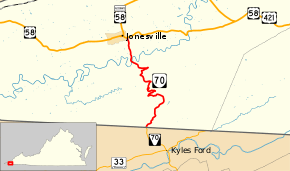
State Route 70 (SR 70) is a primary state highway in Lee County, Virginia, running from the Tennessee state line to U.S. Route 58 in Jonesville. Its continuation in Tennessee, also numbered State Route 70, continues south to the North Carolina state line at North Carolina Highway 208.
Route description
SR 70 begins at the Tennessee state line in the valley formed by Blackwater Creek. It follows that creek past Blackwater, but soon leaves it to ascend Powell Mountain, which it crosses at Hunter Gap. SR 70 comes down off that mountain and then rises again, crossing Wallen Ridge before descending again and crossing the Powell River on Sewell Bridge. From there it heads north across a relatively flat area, ending at US 58 in the eastern part of Jonesville.[2]
History
The road from Jonesville south via Blackwater to Tennessee was part of the Trail of the Lonesome Pine, an auto trail from Detroit to Florida. In 1924, a group of citizens from far western Virginia appeared before the State Highway Commission, asking them to take it over as a state highway. A member of the Tennessee Legislature stated that be was sure that it would be designated a state highway in Tennessee if Virginia took over their part.[3] The northernmost two miles (3 km) were added later in 1924[4] as SR 1010, and a further 8 miles (13 km) were added in 1927.[5] SR 1010 was renumbered to SR 103 in the 1928 renumbering, and the final 3.5-mile (5.5 km) piece from Blackwater to Tennessee was added that year.[6]
In the 1933 renumbering, SR 103 south of Jonesville was combined with the remaining piece of SR 11, which ran from Jonesville northeast to Lebanon along present U.S. Route 58 Alternate (and its old alignments) and SR 71, to form State Route 64. (SR 11 had continued to Bluefield, West Virginia along US 19.)[7] In late 1940, most of SR 64 was renumbered as SR 70, running from Tennessee to St. Paul, to match Tennessee's SR 70. North of St. Paul, SR 64 replaced the former SR 70 (now SR 63), while SR 64 remained on its old alignment from St. Paul southeast to Dickensonville, and switched places with SR 71 to end at Hansonville. Additionally, while SR 64 had gone from Pennington Gap towards Big Stone Gap via Woodway, the new SR 70 replaced SR 66 via Dryden; the old SR 64 from Woodway towards Big Stone Gap became SR 65.[8]
US 58 Alt. was formed in the early 1950s, and replaced all of SR 70 east of Jonesville, truncating it to its current length.[9] In 1954, SR 70 became a secondary route, SR 798, over objections.[10][11] It was added back to the primary system in 1962, after being reconstructed, including the building of a new bridge over the Powell River.[12]
Major intersections
The entire route is in Lee County.
| Location | mi[1] | km | Destinations | Notes | |
|---|---|---|---|---|---|
| | 0.00 | 0.00 | Tennessee state line | ||
| Jonesville | 11.88 | 19.12 | |||
| 1.000 mi = 1.609 km; 1.000 km = 0.621 mi | |||||
References
- 1 2 3 "2005 Virginia Department of Transportation Jurisdiction Report - Daily Traffic Volume Estimates - Lee County" (PDF). (230 KiB)
- ↑ Google (August 7, 2014). "Virginia State Route 70" (Map). Google Maps. Google. Retrieved August 7, 2014.
- ↑ State Highway Commission of Virginia (January 8–9, 1924). Minutes of Meeting (PDF) (Report). Richmond, VA: Commonwealth of Virginia., pages 3-4
- ↑ State Highway Commission of Virginia (April 10–11, 1924). Minutes of Meeting (PDF) (Report). Richmond, VA: Commonwealth of Virginia., page 6
- ↑ State Highway Commission of Virginia (March 11, 1927). Minutes of Meeting (PDF) (Report). Richmond, VA: Commonwealth of Virginia., page 7
- ↑ State Highway Commission of Virginia (August 9–10, 1928). Minutes of Meeting (PDF) (Report). Richmond, VA: Commonwealth of Virginia., page 12
- ↑ Virginia Highways Project: VA 64
- ↑ State Highway Commission of Virginia (October 10, 1940). Minutes of Meeting (PDF) (Report). Richmond, VA: Commonwealth of Virginia., page 12
- ↑ Virginia Highways Project: US 58 ALT
- ↑ State Highway Commission of Virginia (July 20, 1954). Minutes of Meeting (PDF) (Report). Richmond, VA: Commonwealth of Virginia., page 29
- ↑ State Highway Commission of Virginia (August 3–5, 1954). Minutes of the Meeting of the State Highway Commission of Virginia: Conference at Mountain Lake and Inspection Trip in that Area (PDF) (Report). Mountain Lake, VA: Commonwealth of Virginia., page 3
- ↑ State Highway Commission of Virginia (June 21, 1962). Minutes of Meeting (PDF) (Report). Richmond, VA: Commonwealth of Virginia., page 14
External links
| < SR 109 | Spurs of SR 10 1923-1928 |
SR 1011 > |
| < SR 102 | District 1 State Routes 1928–1933 |
SR 104 > |