Virginia State Route 94
| ||||
|---|---|---|---|---|
 | ||||
| Route information | ||||
| Maintained by VDOT | ||||
| Length: | 28.39 mi[1] (45.69 km) | |||
| Existed: | 1933 – present | |||
| Major junctions | ||||
| South end: |
| |||
|
| ||||
| North end: |
| |||
| Location | ||||
| Counties: | Grayson, Carroll, Wythe | |||
| Highway system | ||||
| ||||

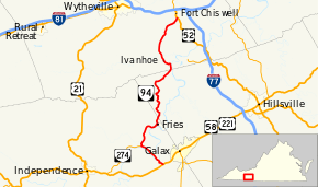
State Route 94 (SR 94) is a primary state highway in the U.S. state of Virginia. Known for much of its length as Ivanhoe Road, the state highway runs 28.39 miles (45.69 km) from U.S. Route 58 and US 221 near Galax north to US 52 in Fort Chiswell. SR 94 connects Galax, Wytheville, and Independence (via SR 274) with the communities of Fries and Ivanhoe along the New River, which the highway parallels for much of its length.
Route description
SR 94 begins at an intersection with US 58 and US 221 (Grayson Parkway) in Grayson County west of Galax. The state highway heads northwest as Riverside Drive, which crosses the New River and parallels the river upstream to the highway's intersection with SR 274 (Riverside Drive). At that intersection, SR 94 turns north onto Scenic Road, which heads toward the town of Fries. The state highway parallels the New River, this time following it downstream, into the town limits to the west end of Main Street, where SR 94 makes a sharp turn northwest onto Ivanhoe Road. The state highway ascents out of the narrow river valley and enters Carroll County. SR 94 has a curvaceous path that crosses Brush Creek and Little Brush Creek and passes to the west of Cold Ridge. The state highway straightens and approaches the New River again as it enters Wythe County, then curves northwest and passes through the village of Ivanhoe. SR 94 heads north out of Ivanhoe, crosses Cripple Creek, and runs straight between intersections with its old alignment, named Virginia 94 Old or Sheffey School Road. The state highway reaches its northern terminus at the east end of Lick Mountain at an intersection with US 52 (Fort Chiswell Road) in Fort Chiswell.[1][2]
Major intersections
| County | Location | mi[1] | km | Destinations | Notes | |||
|---|---|---|---|---|---|---|---|---|
| Grayson | Reavistown | 0.00 | 0.00 | |||||
| | 4.22 | 6.79 | Eastern terminus of SR 274 | |||||
| Providence | former SR 95 west | |||||||
| Fries | ||||||||
| Carroll |
No major junctions | |||||||
| Wythe | Porters Crossroads | former planned SR 81 | ||||||
| Farmers Store | 28.39 | 45.69 | ||||||
| 1.000 mi = 1.609 km; 1.000 km = 0.621 mi | ||||||||
References
- 1 2 3 "2010 Traffic Data". Virginia Department of Transportation. 2010. Retrieved 2011-10-20.
- Grayson County (PDF)
- Carroll County and City of Galax (PDF)
- Wythe County (PDF)
- ↑ Google (2011-10-20). "Virginia State Route 94" (Map). Google Maps. Google. Retrieved 2011-10-20.
External links
| < SR 57 | Two‑digit State Routes 1923-1933 |
SR 59 > |
| < SR 120 | Spurs of SR 12 1923-1928 |
SR 122 > |