Virginia State Route 96
| ||||
|---|---|---|---|---|
 | ||||
| Route information | ||||
| Maintained by VDOT | ||||
| Length: | 7.83 mi[1] (12.60 km) | |||
| Existed: | 1940 – present | |||
| Major junctions | ||||
| West end: |
| |||
|
| ||||
| East end: |
| |||
| Location | ||||
| Counties: | Halifax | |||
| Highway system | ||||
| ||||

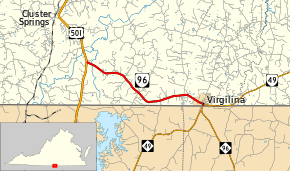
State Route 96 (SR 96) is a primary state highway in the U.S. state of Virginia. Known for most of its length as Virgilina Road, the state highway runs 7.83 miles (12.60 km) from U.S. Route 501 (US 501) near Cluster Springs east to the North Carolina state line in Virgilina. In Virgilina, SR 96 runs concurrently with SR 49 south to the border, where the highways continue as North Carolina Highway 96 and NC 49, respectively.
Route description
SR 96 begins at an intersection with US 501 (Huell Matthews Highway) south of Cluster Springs in southern Halifax County. The state highway heads southeast as Virgilina Road, which crosses Mayo Creek. East of Bluewing Creek, SR 96 heads east to the town of Virgilina, where the highway follows 7th Street. In the center of town, the state highway meets SR 49 at Florence Avenue. Northbound SR 49 follows 7th Street toward Clarksville while both state highways turn south onto Florence Avenue. After crossing over the former alignment of the Norfolk, Franklin and Danville Railway, the two highways reach their respective termini at the North Carolina state line. The two highways, which retain their numbers south of the border, continue south for a short distance before diverging; NC 49 heads southwest toward Roxboro and NC 96 heads southeast toward Oxford.[1][2]
History
SR 96 was originally part of State Route 302, added in 1931 from State Route 18 (now US 501) east three miles (5 km) towards Virgilina.[3] By 1932, this southern piece of SR 302 became part of State Route 59, and that year it was extended east the rest of the way to Virgilina.[4] In the 1933 renumbering, all of SR 59 became part of State Route 49. The piece west of Virgilina, as well as the several blocks south to the state line in Virgilina (which had not been numbered before then[5]), became State Route 96 in the 1940 renumbering to match North Carolina Highway 96.[6]
Major intersections
The entire route is in Halifax County.
| Location | mi[1] | km | Destinations | Notes | |
|---|---|---|---|---|---|
| | 0.00 | 0.00 | |||
| Virgilina | 7.70 | 12.39 | Western end of SR 49 concurrency | ||
| 7.83 | 12.60 | North Carolina state line; eastern end of SR 49 concurrency | |||
1.000 mi = 1.609 km; 1.000 km = 0.621 mi
| |||||
References
- 1 2 3 "2010 Traffic Data". Virginia Department of Transportation. 2010. Retrieved 2011-10-20.
- Halifax County (PDF)
- ↑ Google (2011-10-20). "Virginia State Route 96" (Map). Google Maps. Google. Retrieved 2011-10-20.
- ↑ State Highway Commission of Virginia (December 18, 1930). Minutes of Meeting (PDF) (Report). Lynchburg, VA: Commonwealth of Virginia., page 9
- ↑ State Highway Commission of Virginia (July 27–29, 1932). Minutes of Meeting (PDF) (Report). Marion, Roanoke, and Richmond, VA: Commonwealth of Virginia., page 17
- ↑ Map of Halifax County, revised July 1, 1936
- ↑ State Highway Commission of Virginia (October 10, 1940). Minutes of Meeting (PDF) (Report). Richmond, VA: Commonwealth of Virginia., page 14
External links
| < SR 301 | District 3 State Routes 1928–1933 |
SR 303 > |