Vrh pri Boštanju
| Vrh pri Boštanju | |
|---|---|
 Vrh pri Boštanju Location in Slovenia | |
| Coordinates: 46°0′19.65″N 15°15′32.44″E / 46.0054583°N 15.2590111°ECoordinates: 46°0′19.65″N 15°15′32.44″E / 46.0054583°N 15.2590111°E | |
| Country |
|
| Traditional region | Lower Carniola |
| Statistical region | Lower Sava |
| Municipality | Sevnica |
| Area | |
| • Total | 5.37 km2 (2.07 sq mi) |
| Elevation | 394.5 m (1,294.3 ft) |
| Population (2002) | |
| • Total | 182 |
| [1] | |
Vrh pri Boštanju (pronounced [ˈʋəɾx pɾi bɔˈʃtaːnju]; German: Werch[2]) is a settlement in the hills southwest of Boštanj in the Municipality of Sevnica in east-central Slovenia. The area is part of the historical region of Lower Carniola. The municipality is now included in the Lower Sava Statistical Region.[3] The settlement includes the hamlets of Dule, Pleček, Gabrnik, Ravne, Topolovec, Grič, Hrib, Dobje, Reviše, Volčje Jame (German: Wolfsgraben[2]), Drče, Okič, Sleme, Drenovec, Straški Hrib, and Lipoglav.[4]
Name
The name of the settlement was changed from Vrh to Vrh pri Boštanju in 1953.[5] In the past the German name was Werch.[2]
Mass grave
Vrh pri Boštanju is the site of a mass grave from the period immediately after the Second World War. The Grahovica Mass Grave (Slovene: Grobišče ob Grahovici) is located on a slope west of the Medved farm below a path into the woods, about 50 m from the house and 50 m from the road. It contains the remains of a group of Croatian prisoners of war that tried to pass photos to local residents before being taken away and murdered in May 1945.[6]
Churches
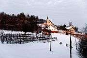
_-_cerkev_sv._Ane.jpg)
There are two churches in the settlement. Both belongs to the Parish of Boštanj. The pilgrimage church dedicated to the Assumption of Mary is built on top of Topolovec Hill south of Grahovica Creek. It was built in 1734.[7] A second church in the western part of the settlement (the hamlet of Okič) is dedicated to Saint Anne and dates to the 17th century.[8]
References
- ↑ Statistical Office of the Republic of Slovenia
- 1 2 3 Leksikon občin kraljestev in dežel zastopanih v državnem zboru, vol. 6: Kranjsko. 1906. Vienna: C. Kr. Dvorna in Državna Tiskarna, pp. 86–87.
- ↑ Sevnica municipal site
- ↑ Savnik, Roman, ed. 1976. Krajevni leksikon Slovenije, vol. 3. Ljubljana: Državna založba Slovenije. pp. 281–282.
- ↑ Spremembe naselij 1948–95. 1996. Database. Ljubljana: Geografski inštitut ZRC SAZU, DZS.
- ↑ Grahovica Mass Grave on Geopedia (Slovene)
- ↑ "EŠD 1658". Registry of Immovable Cultural Heritage (in Slovenian). Ministry of Culture of the Republic of Slovenia. Retrieved 21 October 2011.
- ↑ "EŠD 1654". Registry of Immovable Cultural Heritage (in Slovenian). Ministry of Culture of the Republic of Slovenia. Retrieved 21 October 2011.
External links
 Media related to Vrh pri Boštanju at Wikimedia Commons
- Vrh pri Boštanju at Geopedia
