Vrhpolje, Vipava
| Vrhpolje | |
|---|---|
 | |
 Vrhpolje Location in Slovenia | |
| Coordinates: 45°51′52.76″N 13°57′45.66″E / 45.8646556°N 13.9626833°ECoordinates: 45°51′52.76″N 13°57′45.66″E / 45.8646556°N 13.9626833°E | |
| Country |
|
| Traditional region | Littoral |
| Statistical region | Gorizia |
| Municipality | Vipava |
| Area | |
| • Total | 4.31 km2 (1.66 sq mi) |
| Elevation | 137.5 m (451.1 ft) |
| Population (2002) | |
| • Total | 568 |
| [1] | |
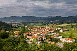
Vrhpolje (pronounced [ʋəɾxˈpoːljɛ]) is a settlement in the Vipava Valley north of the town of Vipava in the Littoral region of Slovenia.[2]
Unmarked graves
Vrhpolje is the site of two unmarked graves from the Second World War. The Church Grave (Slovene: Grobišče ob cerkvi) is located in the middle of the tree-lined avenue by the parish church. It contains the remains of a German soldier killed near Vipava during the war.[3] The Zavetnik Farm Grave (Grobišče Zavetnikov grunt) lies in the woods below a vineyard, about 1 km north-northeast of the parish church. It contains the remains of the Slovene civilian Marija Krapež from Malo Polje, who was murdered by the Partisans in November 1943.[4]
Church
The parish church in the settlement is dedicated to Saints Primus and Felician and belongs to the Koper Diocese.[5]
References
External links
 Media related to Vrhpolje, Vipava at Wikimedia Commons
- Vrhpolje at Geopedia
- Vrhpolje pri Vipavi
| Settlements | 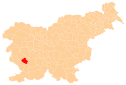 | |
|---|---|---|
| Landmarks |
| |
| Notable people |
| |