Vyšný Orlík
| Vyšný Orlík | |
| Village | |
 | |
| Country | Slovakia |
|---|---|
| Region | Prešov |
| District | Svidník |
| Elevation | 283 m (928 ft) |
| Coordinates | 49°21′N 21°30′E / 49.350°N 21.500°ECoordinates: 49°21′N 21°30′E / 49.350°N 21.500°E |
| Area | 14.716 km2 (5.68 sq mi) |
| Population | 413 (2004-12-31) |
| Density | 28/km2 (73/sq mi) |
| First mentioned | 1414 |
| Postal code | 090 11 |
| Car plate | SK |
  Location of Vyšný Orlík in Slovakia | |
  Location of Vyšný Orlík in the Prešov Region | |
| Statistics: MOŠ/MIS | |
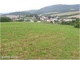
Vyšný Orlík is a village and municipality in Svidník District in the Prešov Region of north-eastern Slovakia.
History
The village was first mentioned in 1414 and had various names throughout history such as Felsoodor (1907-1913) and later, Vyšný Orlík. The Greek Catholic church of the Accession of the Lord was established in 1793 and this village is predominately Carpatho-Rusyn Greek Catholic.
A more detailed history with photographs can be found at....
Vyšný Orlík - The Carpathian Connection
Geography
The municipality lies at an altitude of 283 metres and covers an area of 14.716 km². It has a population of about 413 people.
This article is issued from Wikipedia - version of the 5/3/2014. The text is available under the Creative Commons Attribution/Share Alike but additional terms may apply for the media files.