Wädenswil
| Wädenswil | ||
|---|---|---|
 | ||
| ||
 Wädenswil | ||
|
Location of Wädenswil 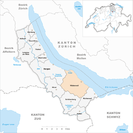 | ||
| Coordinates: 47°14′N 8°40′E / 47.233°N 8.667°ECoordinates: 47°14′N 8°40′E / 47.233°N 8.667°E | ||
| Country | Switzerland | |
| Canton | Zürich | |
| District | Horgen | |
| Government | ||
| • Executive |
Stadtrat with 7 members | |
| • Mayor |
Stadtpräsident (list) Philipp Kutter (as of October 2014) | |
| • Parliament |
Gemeinderat with 35 members | |
| Area[1] | ||
| • Total | 17.39 km2 (6.71 sq mi) | |
| Elevation | 407 m (1,335 ft) | |
| Population (Dec 2015[2]) | ||
| • Total | 21,569 | |
| • Density | 1,200/km2 (3,200/sq mi) | |
| Postal code | 8820 | |
| SFOS number | 0142 | |
| Surrounded by | Au, Zürich, Hirzel, Horgen, Männedorf, Meilen, Richterswil, Schönenberg, Stäfa, Uetikon am See | |
| Website |
www SFSO statistics | |
Wädenswil, locally often called Wädi or Wädischwil, is a municipality in the district of Horgen in the canton of Zürich in Switzerland. The population (as of 2013) was about 21,000.[3]
Geography
Wädenswil has an area of 17.4 km2 (6.7 sq mi). Of this area, 59.3% is used for agricultural purposes, while 9.6% is forested. Of the rest of the land, 29.8% is settled (buildings or roads) and the remainder (1.3%) is non-productive (rivers, glaciers or mountains).[4] In 1996 housing and buildings made up 20.8% of the total area, while transportation infrastructure made up the rest (9%).[5] Of the total unproductive area, water (streams and lakes) made up 0.4% of the area. As of 2007 24.5% of the total municipal area was undergoing some type of construction.[5]
Demographics
Wädenswil has a population (as of 31 December 2015) of 21,569.[2] As of 2007, 20.5% of the population was made up of foreign nationals. As of 2008 the gender distribution of the population was 48.6% male and 51.4% female. Over the last 10 years the population has grown at a rate of 2.1%. Most of the population (as of 2000) speaks German (85.0%), with Italian being second most common ( 3.9%) and Serbo-Croatian being third ( 1.9%).
In the 2007 election the most popular party was the SVP which received 35.2% of the vote. The next three most popular parties were the SPS (17.6%), the FDP (13%) and the CSP (11.3%).
The age distribution of the population (as of 2000) is children and teenagers (0–19 years old) make up 22% of the population, while adults (20–64 years old) make up 64.2% and seniors (over 64 years old) make up 13.9%. In Wädenswil about 76.7% of the population (between age 25–64) have completed either non-mandatory upper secondary education or additional higher education (either university or a Fachhochschule). There are 8796 households in Wädenswil.[5]
Wädenswil has an unemployment rate of 2.94%. As of 2005, there were 268 people employed in the primary economic sector and about 84 businesses involved in this sector. 2020 people are employed in the secondary sector and there are 195 businesses in this sector. 5169 people are employed in the tertiary sector, with 725 businesses in this sector.[4] As of 2007 44.8% of the working population were employed full-time, and 55.2% were employed part-time.[5]
As of 2008 there were 6128 Catholics and 7507 Protestants in Wädenswil. In the 2000 census, religion was broken down into several smaller categories. From the census, 43.5% were some type of Protestant, with 40.5% belonging to the Swiss Reformed Church and 3% belonging to other Protestant churches. 32.2% of the population were Catholic. Of the rest of the population, 5% were Muslim, 7.5% belonged to another religion (not listed), 4% did not give a religion, and 11.9% were atheist or agnostic.[5]
Cultural heritage
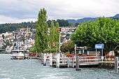
Located on Zürichsee lakeshore, Wädenswil–Vorder Au is part of the 56 Swiss sites of the UNESCO Worl Heritage Site Prehistoric pile dwellings around the Alps,[6] and the settlement is also listed in the Swiss inventory of cultural property of national and regional significance as a Class object.[7]
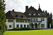
The Schloss Au on the Au Peninsula, its auxiliary buildings and the park are listed in the Swiss inventory of cultural property of national and regional significance as a Class B object of regional importance.[8] The Wädenswil brewery in Swiss canton of Zurich was a brewery in Wädenswil who until 1990 was of 1833 in operation. The building of the former brewery in 2003 was partially demolished. The tradition of Wädenswiler beers continues since 1992 from the "Wadi-Brau-Huus AG».
Transportation

The municipality is located on the A3 motorway.
Wädenswil railway station is served by Zürich S-Bahn services S2 and S8 on the lakeside line to Zürich, and is the terminus of the S13 service to Einsiedeln. It is also served by an hourly long distance service, generally an InterRegio service between Basel and Chur, but sometimes a EuroCity between Hamburg or Brussels and Chur. It is a 29-minute ride from Zürich Hauptbahnhof by the S8.[9]
The Zimmerberg bus line (Zimmerbergbus), provided by the Sihltal Zürich Uetliberg Bahn (SZU), connects the Zimmerberg region and parts of the Sihl valley.
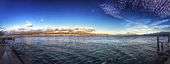
In summer, Wädenswil is served by regular ship services between Zürich and Rapperswil, run by the Zürichsee-Schifffahrtsgesellschaft (ZSG) and calling at various lake side towns. A passenger ferry, operated on an hourly basis throughout the year by the same company, links Wädenswil with both Männedorf and Stäfa on the opposite shore of the lake. The ZSG's motor ship Wädenswil is named after the town.[10][11]
Education
Public schools
The public Primarschule is supervised by the commune's Schulpflege. The board consists of nine elected members.[12]
The Kindergarten are:
The Primarschulen are:
The Oberstufenschule Wädenswil (OSW)[24] is:
The OSW is supervised by the commune's Schulpflege. The board consists of nine elected members.[29]
- Musikschule Wädenswil-Richterswil[30]
Vocational schools
- Hotel & Gastro formation Zürich - Ausbildungszentrum WäBi[31]
- Strickhof/Berufsbildungszentrum (BZW)[32]
- Regionales Ausbildungszentrum (RAU)[33]
- Stiftung Bühl - Zentrum für Heilpädagogik und berufliche Eingliederung[34]
Universities
- ZHAW Wädenswil - Kompetenzzentrum für Life Sciences und Facility Management[35]
Other private schools
The Zürich International School, an international school with an American curriculum, has its Lower School and Early ZIS campus (for early childhood and primary school) in Wädenswil.[36] ZIS' Kindergarten and primary school is approved by the bureau for elementary school (Volksschulamt) of the canton of Zürich. However, it does not approve ZIS for its lower and upper secondary education (Sekundarstufe I aka Sekundarschule, and Sekundarstufe II aka Mittelschule). Therefore, its upper secondary school is not approved by the Swiss Federation, neither.[37][38]
Weather
Between 1961 and 1990 Wädenswil had an average of 141.6 days of rain per year and on average received 1,353 mm (53.3 in) of precipitation. The wettest month was August during which time Wädenswil received an average of 157 mm (6.2 in) of precipitation. During the wettest month, there was precipitation for an average of 13.3 days. The month with the most precipitation days was May, with an average of 13.7 days.[39]
| Climate data for Wädenswil (1981-2010) | |||||||||||||
|---|---|---|---|---|---|---|---|---|---|---|---|---|---|
| Month | Jan | Feb | Mar | Apr | May | Jun | Jul | Aug | Sep | Oct | Nov | Dec | Year |
| Average high °C (°F) | 2.8 (37) |
4.5 (40.1) |
9.5 (49.1) |
13.9 (57) |
18.7 (65.7) |
21.8 (71.2) |
24.1 (75.4) |
23.3 (73.9) |
18.9 (66) |
13.8 (56.8) |
7.3 (45.1) |
3.8 (38.8) |
13.5 (56.3) |
| Daily mean °C (°F) | 0.3 (32.5) |
1.2 (34.2) |
5.2 (41.4) |
9.0 (48.2) |
13.6 (56.5) |
16.8 (62.2) |
19.0 (66.2) |
18.3 (64.9) |
14.4 (57.9) |
10.2 (50.4) |
4.6 (40.3) |
1.6 (34.9) |
9.5 (49.1) |
| Average low °C (°F) | −2.2 (28) |
−1.8 (28.8) |
1.4 (34.5) |
4.5 (40.1) |
8.9 (48) |
12.1 (53.8) |
14.2 (57.6) |
13.9 (57) |
10.6 (51.1) |
7.0 (44.6) |
2.1 (35.8) |
−0.8 (30.6) |
5.8 (42.4) |
| Average precipitation mm (inches) | 82 (3.23) |
77 (3.03) |
99 (3.9) |
100 (3.94) |
135 (5.31) |
155 (6.1) |
152 (5.98) |
164 (6.46) |
127 (5) |
100 (3.94) |
98 (3.86) |
102 (4.02) |
1,390 (54.72) |
| Average precipitation days (≥ 1.0 mm) | 10.6 | 9.9 | 12.3 | 11.5 | 12.9 | 13.5 | 12.8 | 12.4 | 10.5 | 10.0 | 10.7 | 11.5 | 138.6 |
| Average relative humidity (%) | 82 | 77 | 71 | 68 | 69 | 69 | 70 | 73 | 78 | 82 | 83 | 83 | 75 |
| Mean monthly sunshine hours | 52 | 80 | 132 | 163 | 187 | 199 | 224 | 206 | 151 | 104 | 57 | 41 | 1,595 |
| Source: MeteoSwiss [40] | |||||||||||||
External links
| Wikimedia Commons has media related to Wädenswil. |
- Official website (German)
References
- ↑ Arealstatistik Standard - Gemeindedaten nach 4 Hauptbereichen
- 1 2 Canton of Zurich Statistical Office (German) accessed 27 April 2016
- ↑ Bundesamt fur Statistik (Federal Department of Statistics) (2013). "Bilanz der ständigen Wohnbevölkerung (Total) nach Bezirken und Gemeinden". Retrieved 2 September 2015.
- 1 2 Swiss Federal Statistical Office Retrieved 10 August 2009
- 1 2 3 4 5 Statistics Zürich (German) accessed 4 August 2009
- ↑ "Sites Switzerland: Wädenswil–Vorder Au (CH-ZH-07)". palafittes.org. Retrieved 2014-12-08.
- ↑ "A-Objekte KGS-Inventar". Schweizerische Eidgenossenschaft, Amt für Bevölkerungsschutz. 2009. Retrieved 2014-12-08.
- ↑ "B-Objekte KGS-Inventar" (PDF). Schweizerische Eidgenossenschaft, Amt für Bevölkerungsschutz. 2015-02-18. Retrieved 2015-09-18.
- ↑ "S-Bahn trains, buses and boats" (PDF). ZVV. Archived from the original (PDF) on 29 September 2011. Retrieved 4 November 2011.
- ↑ "Zürich–Rapperswil–Schmerikon (Zürichsee/ZVV)" (PDF). Bundesamt für Verkehr. Retrieved 2014-05-15.
- ↑ "Männedorf–Stäfa–Richterswil–Wädenswil (Querfahrten/ZVV)" (PDF). Bundesamt für Verkehr. Retrieved 2014-05-15.
- ↑ "Schulpflege" (in German). Wädenswil, Switzerland: Primarschule Stadt Wädenswil. Retrieved 2015-04-23.
- ↑ "Kindergarten Seeguet." Primarschule Wädenswil. Retrieved on May 4, 2015.
- ↑ "Kindergarten Toblerweg 1." Primarschule Wädenswil. Retrieved on May 4, 2015.
- ↑ "Kindergarten Toblerweg 2." Primarschule Wädenswil. Retrieved on May 4, 2015.
- ↑ "Kindergarten Zopf 1." Primarschule Wädenswil. Retrieved on May 4, 2015.
- ↑ "Kindergarten Zopf 2." Primarschule Wädenswil. Retrieved on May 4, 2015.
- ↑ "Au" (in German). Wädenswil, Switzerland: Primarschule Stadt Wädenswil. Retrieved 2015-05-04.
- ↑ "Eidmatt" (in German). Wädenswil, Switzerland: Primarschule Stadt Wädenswil. Retrieved 2015-05-04.
- ↑ "Gerberacher-Berg" (in German). Wädenswil, Switzerland: Primarschule Stadt Wädenswil. Retrieved 2015-05-04.
- ↑ "Glärnisch" (in German). Wädenswil, Switzerland: Primarschule Stadt Wädenswil. Retrieved 2015-05-04.
- ↑ "KLEINgruppenschule" (in German). Wädenswil, Switzerland: Primarschule Stadt Wädenswil. Retrieved 2015-05-04.
- ↑ "Untermosen" (in German). Wädenswil, Switzerland: Primarschule Stadt Wädenswil. Retrieved 2015-05-04.
- ↑ "Oberstufenschule wädenswil schönenberg hütten" (in German). Wädenswil, Switzerland: Oberstufenschule wädenswil schönenberg hütten. Retrieved 2015-05-04.
- ↑ "Schulhaus Rotweg (Provisorien Pavillon Fuhr)" (in German). Wädenswil, Switzerland: Oberstufenschule wädenswil schönenberg hütten. Retrieved 2015-05-04.
- ↑ "Schulhaus Fhurstrasse" (in German). Wädenswil, Switzerland: Oberstufenschule wädenswil schönenberg hütten. Retrieved 2015-05-04.
- ↑ "Schulhaus Untermosen" (in German). Wädenswil, Switzerland: Oberstufenschule wädenswil schönenberg hütten. Retrieved 2015-05-04.
- ↑ "Schulhaus Steinacher" (in German). Wädenswil, Switzerland: Oberstufenschule wädenswil schönenberg hütten. Retrieved 2015-05-04.
- ↑ "Schulpflege" (in German). Wädenswil, Switzerland: Oberstufenschule wädenswil schönenberg hütten. Retrieved 2015-04-23.
- ↑ "Musikschule Wädenswil-Richterswil" (in German). Wädenswil, Switzerland: Musikschule Wädenswil-Richterswil. Retrieved 2015-05-04.
- ↑ "Hotel & Gastro formation" (in German). Wädenswil, Switzerland: Hotel & Gastro formation Zürich. Retrieved 2015-05-04.
- ↑ "Strickhof" (in German). Wädenswil, Switzerland: Amt für Landschaft und Natur (ALN) der Baudirektion Kanton Zürich. Retrieved 2015-05-04.
- ↑ "Regionales Ausbildungszentrum AU" (in German). Wädenswil, Switzerland: RAU. Retrieved 2015-05-04.
- ↑ "Stiftung Bühl" (in German). Wädenswil, Switzerland: Stiftung Bühl. Retrieved 2015-05-04.
- ↑ "ZHAW Life Sciences und Facility Management" (in German). Zürich, Switzerland: ZHAW. Retrieved 2015-05-04.
- ↑ "Maps and Directions." Zürich International School. Retrieved on April 22, 2015.
- ↑ "Öffentliches Register Privateschulen" [Public Directory for Private Schools] (PDF) (in German). Zürich, Switzerland: Volkschulamt, Bildungsdirektion, Kanton Zürich. 14 April 2015. Retrieved 2015-05-04.
- ↑ "Kantonale Mittelschulen" (in German). Mittelschul- und Berufsbildungsamt, Kanton Zürich. 20 February 2015. Retrieved 2015-04-25.
- ↑ "Temperature and Precipitation Average Values-Table, 1961–1990" (in German, French, and Italian). Federal Office of Meteorology and Climatology – MeteoSwiss. Retrieved 8 May 2009..
- ↑ "Climate Norm Value Tables". Climate diagrams and normals from Swiss measuring stations. Federal Office of Meteorology and Climatology (MeteoSwiss). Retrieved 23 January 2013. The weather station elevation is 485 meters above sea level.
| Settlements |  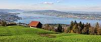 | |
|---|---|---|
| Islands | ||
| Rivers | ||
| Valleys | ||
| Mountains | ||
| Landmarks | ||
| Transportation |
| |
| People | ||