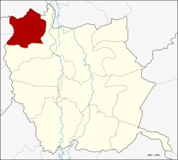
Wachirabarami District
| Wachirabarami วชิรบารมี | |
|---|---|
| Amphoe | |
 Amphoe location in Phichit Province | |
| Coordinates: 16°31′30″N 100°8′42″E / 16.52500°N 100.14500°ECoordinates: 16°31′30″N 100°8′42″E / 16.52500°N 100.14500°E | |
| Country |
|
| Province | Phichit |
| Seat | Ban Na |
| Area | |
| • Total | 259.5 km2 (100.2 sq mi) |
| Population (2005) | |
| • Total | 30,739 |
| • Density | 118.5/km2 (307/sq mi) |
| Time zone | ICT (UTC+7) |
| Postal code | 66140 |
| Geocode | 6612 |
Wachirabarami (Thai: วชิรบารมี) is an amphoe in the northwestern part of Phichit Province, northern Thailand.
Geography
Neighboring districts are (from the north clockwise) Bang Rakam of Phitsanulok Province, Sam Ngam of Phichit Province, Sai Ngam and Lan Krabue of Kamphaeng Phet Province.
History
The district was established on 21 October 1998 by splitting off four tambon from Sam Ngam district.[1]
Administration
The district is divided into four sub-districts (tambon), which are further subdivided into 50 villages (muban). There are no municipal (thesaban) areas, and four tambon administrative organizations (TAO).
| No. | Name | Thai name | Villages | Pop. | |
|---|---|---|---|---|---|
| 1. | Ban Na | บ้านนา | 16 | 10,155 | |
| 2. | Bueng Bua | บึงบัว | 12 | 8,353 | |
| 3. | Wang Mok | วังโมกข์ | 10 | 6,610 | |
| 4. | Nong Lum | หนองหลุม | 12 | 5,621 |
References
- ↑ พระราชกฤษฎีกาตั้งอำเภอวชิรบารมี จังหวัดพิจิตร พ.ศ. ๒๕๔๑ (PDF). Royal Gazette (in Thai). 115 (70 ก): 22–24. October 9, 1998.
External links
This article is issued from Wikipedia - version of the 4/4/2016. The text is available under the Creative Commons Attribution/Share Alike but additional terms may apply for the media files.