Walthamstow Village
| Walthamstow Village | |
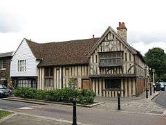
 15th century buildings on Church Lane |
|
 Walthamstow Village |
|
| OS grid reference | TQ385895 |
|---|---|
| – Charing Cross | 7.5 mi (12.1 km) SW |
| London borough | Waltham Forest |
| Ceremonial county | Greater London |
| Region | London |
| Country | England |
| Sovereign state | United Kingdom |
| Post town | LONDON |
| Postcode district | E17 |
| Dialling code | 020 |
| Police | Metropolitan |
| Fire | London |
| Ambulance | London |
| EU Parliament | London |
| UK Parliament | Walthamstow |
| London Assembly | North East |
Coordinates: 51°35′14″N 0°00′08″E / 51.58734°N 0.00223°E
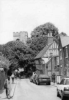
Walthamstow Village is an ancient nucleus of present-day Walthamstow, located in North East London. Designated a Conservation Area by the London Borough of Waltham Forest in 1967, it centres on St. Mary's Church, which was founded in the 12th century. Across the road from this is a 15th-century timber-framed "hall house" which locals have dubbed "The Ancient House". Nearby are almshouses dating from the 16th and 18th centuries, and "Vestry House", which has been used as a workhouse and police station, but has been a museum since 1931. The are also has a museum - Vestry House - which is popular among the locals and visitors alike.
It has recently started a mini-Holland scheme. This has caused some controversy within the community. Orford Road, the ancient road leading up to St Mary's church, has in recent years developed as an attractive street of small restaurants, cafes and an upmarket local supermarket. It also has a variety of nice pubs in the area. One popular favourite pub is named "Queens Arms" which has great customer service and serve nice unique foods.
The area has been described by the London Metropolitan Police as 'a notably affluent area of the ward'.
The area has one bus route; W12, which serves on a hail and ride service.
External links

