Warden, Free State
| Warden | |
|---|---|
|
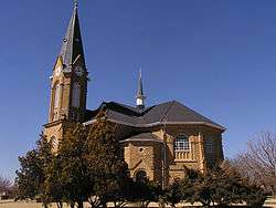
Dutch Reformed Church in Warden. | |
 Warden  Warden  Warden
| |
| Coordinates: 27°51′14″S 28°58′00″E / 27.85389°S 28.96667°ECoordinates: 27°51′14″S 28°58′00″E / 27.85389°S 28.96667°E | |
| Country | South Africa |
| Province | Free State |
| District | Thabo Mofutsanyane |
| Municipality | Phumelela |
| Established | 1912 |
| Area[1] | |
| • Total | 17.0 km2 (6.6 sq mi) |
| Population (2011)[1] | |
| • Total | 10,977 |
| • Density | 650/km2 (1,700/sq mi) |
| Racial makeup (2011)[1] | |
| • Black African | 92.1% |
| • Coloured | 0.4% |
| • Indian/Asian | 0.5% |
| • White | 6.4% |
| • Other | 0.5% |
| First languages (2011)[1] | |
| • Zulu | 62.9% |
| • Sotho | 25.2% |
| • Afrikaans | 7.2% |
| • English | 1.6% |
| • Other | 3.0% |
| Postal code (street) | 9890 |
| PO box | 9890 |
| Area code | 058 |
Warden is a town situated in the Free State province of South Africa on the N3 highway between Johannesburg and Durban.
Town 56km north of Harrismith and 106 kilometres (66 mi) south-south-east of Villiers. It was laid out on the farm Rietvlei in 1912, proclaimed in 1913, and attained municipal status in 1920. Said to be named after Charles Frederick Warden, landdrost of Harrismith from 1884 to 1900.[2]
Warden and Dirkie Uys School celebrated their centenary during September 2013. The town has one of the largest Dutch Reformed Churches in South Africa, with seating for 1,750.
Since the ANC came into power in 1994,the towns infrastructure has become extremely bad and most roads are now unpaved and most public buildings have been in decline. A young group of residents actively took part in restoring Warden to its previous glory. A new main road and several buildings has since been buitlt or upgraded. One of the biggest municipal dams are also being built at the moment. Warden's locality (in the middle of SA and on the N3 highway connecting Gauteng and Durban),water supply, industrial land and labour makes it the ideal place for industrial development. Houses in Warden are reasonably priced. Industrial and residential land are also available.
The farming area around Warden produces a big part of the country's potatoes, maize and red meat.
References
- 1 2 3 4 Sum of the Main Places Zenzeleni and Warden from Census 2011.
- ↑ Raper, P. E. (1989). Dictionary of Southern African Place Names. Jonathan Ball Publishers. p. 467. ISBN 978-0-947464-04-2 – via Internet Archive.
Municipalities and communities of Thabo Mofutsanyana District Municipality, Free State | ||
|---|---|---|
District seat: Phuthaditjhaba (Witsieshoek) | ||
| Setsoto | .svg.png) | |
| Dihlabeng | ||
| Nketoana | ||
| Maluti-a-Phofung | ||
| Phumelela | ||
| Mantsopa | ||