Warm Springs, Virginia
| Warm Springs | |
|---|---|
| Census-designated place (CDP) | |
 Warm Springs Location within the state of Virginia | |
| Coordinates: 38°2′46″N 79°47′26″W / 38.04611°N 79.79056°WCoordinates: 38°2′46″N 79°47′26″W / 38.04611°N 79.79056°W | |
| Country | United States |
| State | Virginia |
| County | Bath |
| Population (2010) | |
| • Total | 123 |
| Time zone | Eastern (EST) (UTC-5) |
| • Summer (DST) | EDT (UTC-4) |
| ZIP codes | 24484 |
Warm Springs is a census-designated place (CDP) in and the county seat of Bath County, Virginia, United States.[1] The population as of the 2010 Census was 123.[2] It lies along U.S. Route 220 near the center of the county. Warm Springs includes the historical mill town called Germantown.
History and geography
The community grew up around the courthouse and the nearby Jefferson Pools. The Bath County Health Department, Sheriff's Department, and other county offices are located adjacent to the courthouse. The Warm Springs Post Office handles mail for the 24484 zip code. Other notable landmarks in Warm Springs are the Bath County Historical Society and the Waterwheel Restaurant, which is located inside of a converted mill. Warm Springs Gallery, located just downhill from the courthouse, specializes in contemporary fine art. Apart from these landmarks, Warm Springs is primarily residential in character, with many renovated inns and historic homes which serve as accommodation for out-of-town visitors. Cowpasture River draws visitors for fishing and kayaking.
Bath County is fairly unusual in Virginia in that it contains no incorporated towns. Nearby Hot Springs is perhaps more well-known than Warm Springs, though the two are separated by only a few miles.
Jefferson Pools, Hidden Valley Rock Shelter (44BA31), Homestead Dairy Barns, Oakley Farm, and Three Hills are listed on the National Register of Historic Places.[3][4]
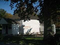 Gentlemen's Pool House, built 1761, the spa waters flow through the centre of the building. President Thomas Jefferson bathed here |
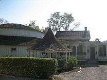 Ladies's Pool House on left, built 1836, with open foot spa in front and Spa Reception to right |
References
- ↑ "Find a County". National Association of Counties. Retrieved 2011-06-07.
- ↑ Virginia Trend Report 2: State and Complete Places (Sub-state 2010 Census Data). Missouri Census Data Center. Accessed 2011-06-08.
- ↑ National Park Service (2010-07-09). "National Register Information System". National Register of Historic Places. National Park Service.
- ↑ "National Register of Historic Places Listings". Weekly List of Actions Taken on Properties: 12/23/13 through 12/27/13. National Park Service. 2014-01-03.
External links
- "Taking the Waters: 19th Century Mineral Springs: Warm Springs." Claude Moore Health Sciences Library, University of Virginia
Municipalities and communities of Bath County, Virginia, United States | ||
|---|---|---|
| CDPs | 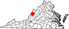 | |
| Unincorporated communities |
| |
| Footnotes | ‡This populated place also has portions in an adjacent county or counties | |