Eldred Township, Lycoming County, Pennsylvania
| Eldred Township, Lycoming County, Pennsylvania | |
|---|---|
| Township | |
|
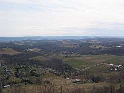
Eldred Township from the Katy Jane Trail at Ryder Park | |
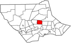 Map of Lycoming County, Pennsylvania highlighting Eldred Township | |
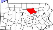 Map of Lycoming County, Pennsylvania | |
| Coordinates: 41°19′27″N 76°57′47″W / 41.32417°N 76.96306°WCoordinates: 41°19′27″N 76°57′47″W / 41.32417°N 76.96306°W | |
| Country | United States |
| State | Pennsylvania |
| County | Lycoming |
| Settled (Warrensville) | 1802 |
| Formed | 1858 |
| Area | |
| • Total | 14.3 sq mi (37.1 km2) |
| • Land | 14.3 sq mi (37.1 km2) |
| • Water | 0.0 sq mi (0.0 km2) |
| Elevation | 915 ft (279 m) |
| Population (2000) | |
| • Total | 2,178 |
| • Density | 152.1/sq mi (58.7/km2) |
| Time zone | Eastern Time Zone (North America) (UTC-5) |
| • Summer (DST) | EDT (UTC-4) |
| FIPS code | 42-22880[1] |
| GNIS feature ID | 1216747[2] |
Eldred Township is a township in Lycoming County, Pennsylvania, United States. The population was 2,178 at the 2000 census. It is part of the Williamsport, Pennsylvania Metropolitan Statistical Area. The unincorporated village of Warrensville is located in Eldred Township.
History
Formation and Early Settlement
Eldred Township is one of the smallest townships in Lycoming County. A petition was filed proposing the formation of the new township from Hepburn Township in 1858. The court directed an election to be held at Warrensville, on October 12, 1858. The question of division was hotly contested, resulting in 109 votes for to 91 against the proposition. On the November 16, 1858, Judge Jordan made a decree erecting the township, and it was named Eldred, in honor of C. D. Eldred, who was then an associate on the bench.[3]
The first white settlers in Eldred Township were mostly Quakers, attracted by the land speculations of Robert Morris, and others in Muncy Township. Among these settlers were the Winners, Wilsons, and Marshalls. The neighborhood of their settlement is now known by the title of "Quaker Hill."[3]
In 1892, in the northern part of the township, David Kiess & Brother owned and ran a sawmill; J. W. Milnor, Sr., also had one in the same section and in the southeastern part of the township there was one run by C. D. Heim. All these mills were located on and fed by Mill Creek. There were two gristmills in Warrensville: one, owned by J. K. Crawford, was run by water; the other, owned by C. Aderhold, had steam and water both.
Warrensville
Warrensville is the only village in the township. The story of the origin of its name is as follows: In 1842, when there was talk of applying for a postoffice, several persons met in the store of John Hoffman, on Mill creek, and the question Warrensville, in honor of General Warren, was proposed, of a name came up. while others suggested Livingston. A vote was taken and Warrensville carried. The postoffice was established July 25, 1842, named Warrensville, and Samuel Torbert was appointed postmaster.[3]
The land on which Warrensville stands was cleared in 1802 by Samuel Carpenter. He erected a grist and saw mill and carding machine, which were the first improvements of the kind in the settlement. They proved of great service to the early settlers. These original works have long since passed out of existence. The village of Warrensville was laid out in 1841 by John Weisel, but never has been incorporated.[3]
In 1892 it contained two stores and one Temperance Hotel, kept by Isaac M. Else, as well as a tannery, carried on by E. W. Lundy, two wagon makers and two blacksmith shops.
Geography
Eldred Township is bordered by Hepburn Township to the west, Gamble Township to the north, Plunketts Creek and Upper Fairfield Townships to the east, following the course of Loyalsock Creek, and Loyalsock Township to the south.[4] As the crow flies, Lycoming County is about 130 miles (209 km) northwest of Philadelphia and 165 miles (266 km) east-northeast of Pittsburgh.
According to the United States Census Bureau, the township has a total area of 37.1 square kilometres (14.3 sq mi), all land.
Demographics
As of the census[1] of 2000, there were 2,178 people, 770 households, and 646 families residing in the township. The population density was 152.1 people per square mile (58.7/km2). There were 798 housing units at an average density of 55.7/sq mi (21.5/km2). The racial makeup of the township was 98.67% White, 0.37% African American, 0.05% Native American, 0.37% Asian, 0.14% from other races, and 0.41% from two or more races. Hispanic or Latino of any race were 0.18% of the population.
There were 770 households, out of which 39.5% had children under the age of 18 living with them, 75.5% were married couples living together, 5.3% had a female householder with no husband present, and 16.0% were non-families. 13.9% of all households were made up of individuals, and 5.7% had someone living alone who was 65 years of age or older. The average household size was 2.83 and the average family size was 3.12.
In the township the population was spread out, with 27.0% under the age of 18, 7.0% from 18 to 24, 27.4% from 25 to 44, 29.2% from 45 to 64, and 9.4% who were 65 years of age or older. The median age was 39 years. For every 100 females there were 101.7 males. For every 100 females age 18 and over, there were 99.5 males.
The median income for a household in the township was $46,780, and the median income for a family was $49,208. Males had a median income of $36,111 versus $21,949 for females. The per capita income for the township was $19,426. About 4.5% of families and 5.1% of the population were below the poverty line, including 7.2% of those under age 18 and 7.5% of those age 65 or over.
Streams
Mill Creek, the principal stream, has its source in the township and empties into Loyalsock Creek about 1-mile (1.6 km) above Montoursville. Its tributaries are Sugar Camp Creek, in the northern part of the township; Caleb's Creek is in the northeastern part, and Lick Run, in the southern part. Miller's Run, which rises in the southwestern part of the township, empties into the West Branch Susquehanna River east of Williamsport.
References
- 1 2 "American FactFinder". United States Census Bureau. Retrieved 2008-01-31.
- ↑ "US Board on Geographic Names". United States Geological Survey. 2007-10-25. Retrieved 2008-01-31.
- 1 2 3 4 Meginness, John Franklin (1892). "Loyalsock, Hepburn, and Eldred". History of Lycoming County, Pennsylvania: including its aboriginal history; the colonial and revolutionary periods; early settlement and subsequent growth; organization and civil administration; the legal and medical professions; internal improvement; past and present history of Williamsport; manufacturing and lumber interests; religious, educational, and social development; geology and agriculture; military record; sketches of boroughs, townships, and villages; portraits and biographies of pioneers and representative citizens, etc. etc. (1st ed.). Chicago: Brown, Runk & Co. ISBN 0-7884-0428-8. Retrieved 2007-02-20.
(Note: ISBN refers to Heritage Books July 1996 reprint. URL is to a scan of the 1892 version with some OCR typos).
- ↑ "2007 General Highway Map Lycoming County Pennsylvania" (PDF) (Map). 1:65,000. Pennsylvania Department of Transportation, Bureau of Planning and Research, Geographic Information Division. Retrieved 2009-12-24.
Municipalities and communities of Lycoming County, Pennsylvania, United States | ||
|---|---|---|
| City | | |
| Boroughs | ||
| Townships |
| |
| CDPs | ||
| Unincorporated communities | ||
| Ghost town | ||
| Footnotes | ‡This populated place also has portions in an adjacent county | |