Washington Park MAX Station
Washington Park | ||||||||||||||||
|---|---|---|---|---|---|---|---|---|---|---|---|---|---|---|---|---|
| MAX Light Rail Station | ||||||||||||||||
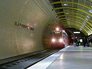 An eastbound Blue Line train entering the station | ||||||||||||||||
| Location |
Washington Park near Oregon Zoo and Southwest Knights Boulevard Portland, Oregon USA | |||||||||||||||
| Coordinates | 45°30′38″N 122°43′01″W / 45.510661°N 122.716869°WCoordinates: 45°30′38″N 122°43′01″W / 45.510661°N 122.716869°W | |||||||||||||||
| Owned by | TriMet | |||||||||||||||
| Platforms | 1 island platform | |||||||||||||||
| Tracks | 2 | |||||||||||||||
| Construction | ||||||||||||||||
| Depth | 260 feet (79 m) | |||||||||||||||
| Parking | none | |||||||||||||||
| Disabled access | Yes | |||||||||||||||
| History | ||||||||||||||||
| Opened | 1998 | |||||||||||||||
| Services | ||||||||||||||||
| ||||||||||||||||
Washington Park is a light rail station on the MAX Blue and Red Lines. It is located in Portland, Oregon and is a part of the Robertson Tunnel under Portland's West Hills. It is the fourth station westbound on the Westside MAX alignment. While it is the only completely underground station in the MAX system, at 260 feet (79 m) below the surface it is the deepest transit station in North America.[1] It is also one of the deepest in the world.[2]
This station serves many popular destinations. Its surface level plaza is located in the middle of a parking lot surrounded by the Oregon Zoo to the east, World Forestry Center to the west, Portland Children's Museum to the southwest, Oregon Vietnam Veterans Memorial to the northwest, and Hoyt Arboretum to the north. TriMet bus service, including a seasonal shuttle, and trails, some part of the 40 Mile Loop, connect this station to other parts of Washington Park, including the International Rose Test Garden and the Portland Japanese Garden. Buses and MAX from here also connect to the Providence Park MAX Station, West Burnside Street, and Providence Park itself.
History
The station was designed by the Zimmer Gunsul Frasca Partnership architecture firm and built by Hoffman Construction Company, with engineering by Parsons Brinckerhoff.[3] It opened in 1998 along with the rest of the westside MAX Line. Building Design & Construction named the station as its top public works project in 1999 in its Building Team Project of the Year competition.[3]
Description
Surface

The surface portion includes a public plaza named in honor of Les AuCoin, a former member of the U.S. House of Representatives who supported the project. The entrance to the zoo is located just across a parking-lot road from the station plaza, having been moved north from its previous location the weekend after the station opened. Two high-speed elevators are located at either end of the underground station; visitors to the Oregon Zoo are directed to the east elevators while people going to the World Forestry Center are pointed to the west.
Underground
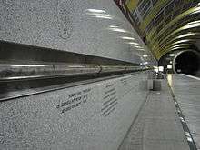
The Robertson Tunnel consists of two single-track tubes, one for each direction of travel. The station platform is between the rails, accessed from the left side of trains. A geological timeline—created from a drilling core sample—runs along the platform walls. The eastbound platform is marked by yellow roof girders, symbolizing the sunrise; the westbound platform has orange roof girders, symbolizing the sunset. The platforms were nicknamed Sunrise and Sunset, respectively, by TriMet.
Trains entering the tunnel more than a mile away can be heard from the platforms. They move at up to 55 mph (89 km/h)[1] and push a stream of constant-temperature air into the station. This, coupled with the surrounding rock, keeps the platform at a natural average temperature of 50 °F (10 °C) year round.
A memorial to the only worker killed during the construction of the Robertson Tunnel is located on the wall next to the tunnel portal at the east end of the "Sunset" (westbound) platform.
Elevators
The elevators stop at only two levels, surface and platform level, with no intermediate stops. As a part of the station's geological theme, the signs inside the elevators refer to these two levels not by conventional floor numbers but by "the present" and "16 million years ago"—for the surface level and platform level, respectively. During ascent and descent, a moving indicator display inside each elevator shows the current position expressed as elevation above sea level in feet. The elevators allow selecting two floors, "S" and "T", for "surface" and "tunnel" (or possibly "street" and "track"). The 26-story (28 for the west elevators) equivalent ride takes about 25 seconds. Due to the hillside surface slope, the west elevators are 20 feet (6.1 m) taller than the east elevators.
Bus line connections
This underground MAX station is served by the following bus lines:
- 63 – Washington Park/Arlington Heights
- Washington Park Free Shuttle (runs May–October only)[6]
References
- 1 2 "Westside MAX Tour Fact Sheet" (PDF). TriMet. November 2009. Retrieved May 3, 2011.
- ↑ "Livable Portland: Land Use and Transportation Initiatives" (PDF). TriMet. November 2010. p. 83. Retrieved May 3, 2011.
- 1 2 Miller, Brian K. (July 4, 1999). "Local team honored for work on light-rail station". Portland Business Journal. Retrieved 21 May 2014.
- ↑ Shrag, John (August 19, 1998). "Humble pi". Willamette Week.
- ↑ "Pieces of pi at Washington Park Station". DocBug. November 20, 2006. Archived from the original on August 2, 2007. Retrieved 20 May 2015.
- ↑ Washington Park Free Shuttle Explore Washington Park/Metro. Retrieved August 31, 2016.
External links
| Wikimedia Commons has media related to Washington Park (MAX station). |
- MAX Light Rail Stations – TriMet page