Washington State Route 163
| ||||
|---|---|---|---|---|
| Pearl Street | ||||
|
SR 163 is highlighted in red. | ||||
| Route information | ||||
| Auxiliary route of SR 16 | ||||
| Defined by RCW 47.17.317 | ||||
| Maintained by WSDOT | ||||
| Length: |
3.37 mi[1] (5.42 km) Mileage does not include ferry route | |||
| Existed: | 1991 (current route)[2] – present | |||
| Major junctions | ||||
| South end: |
| |||
| North end: |
| |||
| Location | ||||
| Counties: | Pierce, King | |||
| Highway system | ||||
| ||||

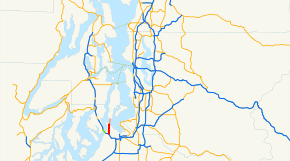
State Route 163 (SR 163) is a 3.37-mile-long (5.42 km) state highway in the U.S. state of Washington. The highway serves the city of Tacoma and the community of Ruston in Pierce County before traveling via a ferry route to the community of Tahlequah on Vashon Island in King County. SR 163 begins at an interchange with SR 16 in Tacoma and travels north as Pearl Street through Ruston to Point Defiance, where the designation continues onto the MV Chetzemoka ferry to Tahlequah.
SR 163 was established during the 1964 highway renumbering, extending from Sumner to Auburn. The highway was previously a part of the Pacific Highway during the early 20th century, but was designated as a branch of State Road 5 and Primary State Highway 5 (PSH 5) until 1964. SR 163 became SR 167 during the late 1960s and was moved to Pearl Street in 1991, with the ferry route being added in 1994.
Route description
SR 163 begins as Pearl Street at a partial cloverleaf interchange with the SR 16 freeway in Tacoma north of Tacoma Community College.[3][4] Pearl Street travels north, serving Woodrow Wilson High School and Truman Middle School,[5][6] before leaving Tacoma and entering Ruston and serving Point Defiance Elementary School.[7][8] The highway re-enters Tacoma at Point Defiance Park and passes the Science and Math Institute before traveling onto the Point Defiance–Tahlequah Ferry.[9][10][11]
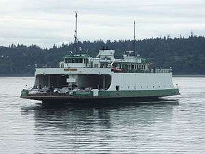
The ferry, operated by Washington State Ferries (WSF), is on a 1.7-mile-long (2.7 km) route and is served by the Kwa-di Tabil class MV Chetzemoka traveling at a speed of 15 knots (17 mph) for a 15-minute crossing.[12] The ferries depart from Port Defiance and head north across the Dalco Passage to the community of Tahlequah on Vashon Island.[13][14][15] WSF operates the ferry every day with 19 crossings,[16][17] as a $5 toll for adult passengers is charged with prepaid Wave2Go cards being accepted.[18]
Every year, the Washington State Department of Transportation (WSDOT) conducts a series of surveys on its highways in the state to measure traffic volume. This is expressed in terms of average annual daily traffic (AADT), which is a measure of traffic volume for any average day of the year. In 2011, WSDOT calculated that between 1,000 and 26,000 vehicles per day used the highway, mostly at the SR 16 interchange in Tacoma.[19] The Point Defiance–Tahlequah ferry carried 650,000 passengers and 383,000 vehicles in 2012, according to WSF statistics.[20]
History
SR 163 was first designated during the 1964 highway renumbering as a road extending from U.S. Route 410 in Sumner to SR 18 in Auburn.[21][22] The corridor was previously a part of the Pacific Highway from 1913 to 1923,[23][24][25] and later became a branch of State Road 5 in 1925.[26][27] State Road 5 became PSH 5 during the creation of the Primary and secondary state highways in 1937, and the branch stayed designated.[28][29][30] SR 163 was removed from the highway system in the late 1960s, and became part of SR 167.[31][32]
SR 163 was re-designated in 1991 along Pearl Street from SR 16 in Tacoma to the Point Defiance ferry terminal.[2][33] The route was extended onto the Point Defiance–Tahlequah Ferry serving Vashon Island in 1994.[2][34] No major revisions have occurred since 1994 to the highway's route.[31]
Regular ferry service on the Dalco Passage between Point Defiance in Tacoma and Tahlequah on Vashon Island started with the MV Skansonia in June 1951 during the creation of the WSF,[35][36] and served the route until the completion of the MV Hiyu in 1967.[37][38] The Hiyu operated for 26 years until it was replaced by the refurbished MV Rhododendron in 1993.[39] The Hiyu briefly returned to the route twice, in June 2008 and in September and October 2008,[40] while the Rhododendron was loaned out to Pierce County for the Steilacoom–Anderson Island ferry.[41][42] The MV Chetzemoka, built in 2010, began serving the route in January 2012.[43]
Major intersections
| County | Location | mi[1] | km | Destinations | Notes |
|---|---|---|---|---|---|
| Pierce | Tacoma | 0.00– 0.08 | 0.00– 0.13 | Southern terminus; interchange | |
| 3.37 | 5.42 | Point Defiance ferry terminal | |||
| Puget Sound | 3.37– 5.40 | 5.42– 8.69 | |||
| King | Tahlequah | 5.40 | 8.69 | Tahlequah ferry terminal | Northern terminus |
| 1.000 mi = 1.609 km; 1.000 km = 0.621 mi | |||||
References
- 1 2 Staff (2012), State Highway Log: Planning Report 2011, SR 2 to SR 971 (PDF), Washington State Department of Transportation, pp. 1117–1119, retrieved January 20, 2013
- 1 2 3 "47.17.317: State route No. 163", Revised Code of Washington, Washington State Legislature, 1994 [1991], retrieved January 20, 2013
- ↑ SR 16 - Junction SR 163 / Pearl St / 6th Avenue (PDF), Washington State Department of Transportation, July 13, 2009, retrieved January 20, 2013
- ↑ "Feature Detail Report for: Tacoma Community College", Geographic Names Information System, United States Geological Survey, May 1, 1992, retrieved January 20, 2013
- ↑ "Feature Detail Report for: Woodrow Wilson High School", Geographic Names Information System, United States Geological Survey, September 10, 1979, retrieved January 20, 2013
- ↑ "Feature Detail Report for: Truman Middle School", Geographic Names Information System, United States Geological Survey, September 10, 1979, retrieved January 20, 2013
- ↑ "Feature Detail Report for: Ruston", Geographic Names Information System, United States Geological Survey, September 10, 1979, retrieved January 20, 2013
- ↑ "Feature Detail Report for: Point Defiance Elementary School", Geographic Names Information System, United States Geological Survey, December 31, 1992, retrieved January 20, 2013
- ↑ "Feature Detail Report for: Point Defiance Park", Geographic Names Information System, United States Geological Survey, September 10, 1979, retrieved January 20, 2013
- ↑ "Feature Detail Report for: Point Defiance Ferry Landing", Geographic Names Information System, United States Geological Survey, June 7, 2010, retrieved January 20, 2013
- ↑ Google (January 20, 2013). "State Route 163" (Map). Google Maps. Google. Retrieved January 20, 2013.
- ↑ "M/V Chetzemoka", Vessel Information, Washington State Ferries, retrieved January 20, 2013
- ↑ Seattle/Vashon/Tacoma Route Map (Map). Washington State Ferries. Retrieved January 20, 2013.
- ↑ "Feature Detail Report for: Dalco Passage", Geographic Names Information System, United States Geological Survey, September 10, 1979, retrieved January 20, 2013
- ↑ "Feature Detail Report for: Tahlequah", Geographic Names Information System, United States Geological Survey, September 10, 1979, retrieved January 20, 2013
- ↑ WSF Sailing Schedule for Pt. Defiance / Tahlequah, Washington State Ferries, December 30, 2012, retrieved January 20, 2013
- ↑ Winter 2013 Sailing Schedule: Pt. Defiance / Tahlequah (PDF), Washington State Ferries, December 30, 2012, retrieved January 19, 2013
- ↑ Passenger and Vehicle Fares (PDF), Washington State Ferries, May 1, 2012, retrieved January 20, 2013
- ↑ Staff (2011), 2011 Annual Traffic Report (PDF), Washington State Department of Transportation, p. 148, retrieved January 20, 2013
- ↑ WSDOT Ferries Division (WSF) - Nation’s Largest Ferry System (PDF), Washington State Department of Transportation, Washington State Ferries, January 2013, retrieved January 20, 2013
- ↑ Prahl, C. G. (December 1, 1965), Identification of State Highways (PDF), Washington State Highway Commission, Department of Highways, retrieved January 20, 2013
- ↑ Seattle, 1965 (JPG) (Map). 1:250,000. United States Geological Survey. 1965. Retrieved January 20, 2013.
- ↑ Washington State Legislature (March 12, 1913), "Chapter 65: Classifying Public Highways", Session Laws of the State of Washington, Session Laws of the State of Washington (1913 ed.), Olympia, Washington: Washington State Legislature, p. 221, retrieved January 20, 2013
- ↑ Washington State Legislature (March 19, 1923), "Chapter 185: Primary and Secondary State Highways", Session Laws of the State of Washington, Session Laws of the State of Washington (1923 ed.), Olympia, Washington: Washington State Legislature, pp. 627–625, retrieved January 20, 2013
- ↑ State of Washington Showing Highways Authorized by Legislative Acts of 1915 (DJVU) (Map). Cartography by Rand McNally. Washington State Bureau of Statistics and Immigration. 1915. Retrieved January 20, 2013.
- ↑ Washington State Legislature (February 18, 1925), "Chapter 26", Session Laws of the State of Washington, Session Laws of the State of Washington (1923 ed.), Olympia, Washington: Washington State Legislature, p. 58, retrieved January 20, 2013
- ↑ Highway Map: State of Washington (DJVU) (Map). Department of Highways. 1933. Retrieved January 20, 2013.
- ↑ Washington State Legislature (March 17, 1937), "Chapter 190: Establishment of Primary State Highways", Session Laws of the State of Washington, Session Laws of the State of Washington (1937 ed.), Olympia, Washington: Washington State Legislature, pp. 936–937, retrieved January 20, 2013
- ↑ Highways of the State of Washington (DJVU) (Map). Washington State Highway Commission. 1939. Retrieved January 20, 2013.
- ↑ Seattle, 1958 (JPG) (Map). 1:250,000. United States Geological Survey. 1958. Retrieved January 20, 2013.
- 1 2 Washington State Highways, 2011–2012 (PDF) (Map). 1:842,000. Washington State Department of Transportation. 2011. Retrieved January 20, 2013.
- ↑ "47.17.330: State route No. 167", Revised Code of Washington, Washington State Legislature, 1970; revised 1979, 1991, retrieved January 20, 2013 Check date values in:
|date=(help) - ↑ Washington State Legislature (May 21, 1991), "Chapter 342: Engrossed Senate Bill 5801", Session Laws of the State of Washington, Session Laws of the State of Washington (1991 ed.), Olympia, Washington: Washington State Legislature
- ↑ Washington State Legislature (March 30, 1994), "Chapter 209: Substitute House Bill 2618", Session Laws of the State of Washington, Session Laws of the State of Washington (1994 ed.), Olympia, Washington: Washington State Legislature, retrieved February 1, 2013
- ↑ Washington State Ferries History, Washington State Department of Transportation, retrieved January 20, 2013
- ↑ Stein, Alan J. (January 20, 2003), "Washington State Ferries begins operations on June 1, 1951.", HistoryLink, retrieved January 20, 2013
- ↑ Stein, Alan J. (February 26, 2003), "Ferry Hiyu is launched on February 24, 1967.", HistoryLink, retrieved January 20, 2013
- ↑ "Ferry Hiyu Will Enter Service Next Sunday", The Seattle Times, Seattle, p. 35, July 12, 1967
- ↑ Demoro, Harre (1971), The Evergreen Fleet – A Pictoral History of Washington State Ferries, San Marino, California: Golden West Books, pp. 34–35, ISBN 087095-037-1
- ↑ Moseley, David (June 6, 2008), WSF Weekly Update (PDF), Washington State Department of Transportation, retrieved January 20, 2013
- ↑ Moseley, David (June 13, 2008), WSF Weekly Update (PDF), Washington State Department of Transportation, retrieved January 20, 2013
- ↑ Moseley, David (September 26, 2008), WSF Weekly Update (PDF), Washington State Department of Transportation, retrieved January 20, 2013
- ↑ Johnson, Natalie (December 13, 2011), "A new ferry, already in need of repairs, is headed to Vashon", Vashon-Maury Island Beachcomber, Vashon, Washington, retrieved January 20, 2013
External links
| Wikimedia Commons has media related to Washington State Route 163. |
Former or proposed: SR 168 | |||