Washington State Route 164
| ||||
|---|---|---|---|---|
| Auburn–Enumclaw Road | ||||
|
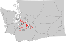
SR 164 is highlighted in red. | ||||
| Route information | ||||
| Auxiliary route of SR 410 | ||||
| Defined by RCW 47.17.320 | ||||
| Maintained by WSDOT | ||||
| Length: | 14.82 mi[1] (23.85 km) | |||
| Existed: | 1964[2] – present | |||
| Major junctions | ||||
| West end: |
| |||
|
| ||||
| East end: |
| |||
| Location | ||||
| Counties: | King | |||
| Highway system | ||||
| ||||


State Route 164 (SR 164) is a 14.82-mile-long (23.85 km) state highway serving southern King County in the U.S. state of Washington. The highway, which connects Auburn and Enumclaw along the White River, begins at an interchange with SR 18 in Auburn and travels southeast to Enucmlaw, where it intersects SR 169 and ends at SR 410. SR 164 serves as an alternate route towards Buckley and Chinook Pass, via SR 410, and also passes the Muckleshoot Indian Reservation.
SR 164 was originally part of various state wagon roads between 1913 and 1923, becoming part of State Road 5, later Primary State Highway 5 (PSH 5), and U.S. Route 410 (US 410) in 1926. US 410 was later realigned south in the 1940s and SR 167 was assigned to the former route during the 1964 highway renumbering. In 1969, SR 164 was established and the western terminus was later shortened to an interchange with SR 18 south of Auburn.
Route description
SR 164 begins as Auburn Way at a partial cloverleaf interchange with the SR 18 freeway south of the Auburn Shopping Center in Downtown Auburn.[3][4] The highway travels southeast and passes Les Grove Park and White River Historical Museum before leaving Auburn,[5][6] following the White River upstream into the Muckleshoot Indian Reservation,[7][8] passing the Muckleshoot Casino. Auburn Way travels east and southeast within the reservation, passing Seattle Air Route Traffic Control Center, the Auburn Adventist Academy and Muckleshoot Tribal School.[9][10] SR 164 leaves the reservation and enters rural King County, continuing to follow the White River as the Auburn–Enumclaw Road and passing the White River Amphitheatre, turning east as it approaches Enumclaw. The highway, now named 436th Street, passes Mahler Park and dips south onto Griffin Avenue into Downtown Enumclaw.[11][12] Griffin Avenue turns southeast and intersects Porter Street, the southern terminus of SR 169, before traveling to an intersection with Roosevelt Avenue, signed as SR 410, where SR 164 ends.[1][13]
Every year, the Washington State Department of Transportation (WSDOT) conducts a series of surveys on its highways in the state to measure traffic volume. This is expressed in terms of average annual daily traffic (AADT), which is a measure of traffic volume for any average day of the year. In 2011, WSDOT calculated that between 9,200 and 34,000 vehicles per day used the highway, mostly in the Auburn area.[14] WSDOT has designated SR 164 as a Highway of Statewide Significance, which includes principal arterials that are needed to connect major communities in the state.[15][16]
History
SR 164 was first defined under law to be built and paved by the state of Washington in 1913 as the McClellan Pass Highway, extending southeast from Tacoma along the Puyallup and White rivers to Chinook Pass and towards Naches along an existing county road from Auburn and Enumclaw built in the 1890s.[17][18][19] The highway was renamed to the Naches Pass Highway in 1921 and became State Road 5 during a 1923 restructuring of the state highway system.[20][21] After the formation of the United States Numbered Highways in 1926, US 410 was created and used the route of State Road 5 between Tacoma and Naches.[22][23] State Road 5 became PSH 5, extended north to Renton and named the National Park Highway, was established during the creation of the Primary and secondary state highways in 1937.[24] US 410 was moved south to a new Sumner–Buckley highway in the 1950s and was replaced by an extension of US 12 in 1967.[25][26] During the 1964 highway renumbering, PSH 5 was split into several highways, including SR 167 between Renton and Enumclaw, ending at SR 410.[27][28] In 1969, SR 167 was moved onto former SR 163 between Sumner and Auburn and SR 164 was established.[2][29] SR 164 originally ended at SR 18 in Downtown Auburn, but was moved south when SR 18 was realigned onto a new freeway in 1987.[30] No major revisions to the route of the highway have occurred since.[31]
Major intersections
The entire highway is in King County.
| Location | mi[1] | km | Destinations | Notes | |
|---|---|---|---|---|---|
| Auburn | 0.00– 0.07 | 0.00– 0.11 | Western terminus; interchange | ||
| Enumclaw | 14.21 | 22.87 | Southern terminus of SR 169 | ||
| 14.82 | 23.85 | Eastern terminus | |||
| 1.000 mi = 1.609 km; 1.000 km = 0.621 mi | |||||
References
- 1 2 3 Staff (2012), State Highway Log: Planning Report 2011, SR 2 to SR 971 (PDF), Washington State Department of Transportation, pp. 1120–1125, retrieved January 28, 2013
- 1 2 "47.17.320: State route No. 164", Revised Code of Washington, Washington State Legislature, 1987 [1970], retrieved January 28, 2013
- ↑ SR 18: Junction SR 164/Auburn Way (PDF), Washington State Department of Transportation, March 2, 2001, retrieved January 28, 2013
- ↑ "Feature Detail Report for: Auburn Shopping Center", Geographic Names Information System, United States Geological Survey, November 1, 1992, retrieved January 28, 2013
- ↑ "Feature Detail Report for: Les Grove Park", Geographic Names Information System, United States Geological Survey, September 10, 1979, retrieved January 28, 2013
- ↑ "Feature Detail Report for: White River Historical Museum", Geographic Names Information System, United States Geological Survey, September 1, 1993, retrieved January 28, 2013
- ↑ "Feature Detail Report for: White River", Geographic Names Information System, United States Geological Survey, September 10, 1979, retrieved January 28, 2013
- ↑ "Feature Detail Report for: Muckleshoot Reservation", Geographic Names Information System, United States Geological Survey, January 1, 1995, retrieved January 28, 2013
- ↑ "Feature Detail Report for: Auburn Adventist Academy", Geographic Names Information System, United States Geological Survey, December 31, 1992, retrieved January 28, 2013
- ↑ "Feature Detail Report for: Muckleshoot Tribal School", Geographic Names Information System, United States Geological Survey, November 3, 2008, retrieved January 28, 2013
- ↑ "Feature Detail Report for: Mahler Park", Geographic Names Information System, United States Geological Survey, January 1, 1995, retrieved January 28, 2013
- ↑ "Feature Detail Report for: Enumclaw", Geographic Names Information System, United States Geological Survey, September 10, 1979, retrieved January 28, 2013
- ↑ Google (November 24, 2010). "State Route 164" (Map). Google Maps. Google. Retrieved November 24, 2010.
- ↑ Staff (2011), 2011 Annual Traffic Report (PDF), Washington State Department of Transportation, p. 148, retrieved January 28, 2013
- ↑ Transportation Commission List of Highways of Statewide Significance (PDF), Washington State Transportation Commission, July 26, 2009, retrieved January 28, 2013
- ↑ Highways Of Statewide Significance (PDF) (Map). Washington State Department of Transportation. 2009. Retrieved January 28, 2013.
- ↑ Washington State Legislature (March 12, 1913), "Chapter 65: Classifying Public Highways", Session Laws of the State of Washington, Session Laws of the State of Washington (1913 ed.), Olympia, Washington: Washington State Legislature, p. 222, retrieved January 28, 2013,
f. A highway starting at a connection with the Pacific Highway at Auburn, Washington; thence along the most feasible route through Enumclaw, following the route of former State Road No. 1, to North Yakima, Washington. At a point in Pierce county where said State Road No. 1 leaves the main channel of White River a branch shall take off which shall follow up the White River Valley to a connection at the most practicable point with the Rainier National Park. Another branch shall take off where Road No. 1 leaves the American River and shall follow said American River by the most feasible route to a connection with the Rainier National Park, this highway and its branches to be known as the McClellan Pass Highway.
- ↑ State of Washington Showing State Highways Authorized by Legislative Acts of 1915 (DJVU) (Map). Bureau of Statistics and Immigration of the State of Washington. 1915. Retrieved January 28, 2013.
- ↑ Washington: Tacoma Quadrangle (JPG) (Map). 1:125,000. United States Geological Survey. March 1900. Retrieved January 28, 2013.
- ↑ Washington State Legislature (March 2, 1921), "Chapter 34: McClellan Pass", Session Laws of the State of Washington, Session Laws of the State of Washington (1921 ed.), Olympia, Washington: Washington State Legislature, p. 118, retrieved January 28, 2013,
SECTION 1. The name of that certain primary state highway established by section 6 of chapter 164 of the Laws of 1915 as the McClellan Pass highway, is hereby changed to, and said highway shall be known as, the Naches Pass highway.
- ↑ Washington State Legislature (March 19, 1923), "Chapter 185: Primary and Secondary State Highways", Session Laws of the State of Washington, Session Laws of the State of Washington (1923 ed.), Olympia, Washington: Washington State Legislature, pp. 628–629, retrieved January 28, 2013,
SEC. 4. A primary state highway, to be known as State Road No. 5 or the National Park Highway System, is established as follows: Beginning at the City of Tacoma; thence by the most feasible route in a southeasterly direction through Elbe and Ashford to the Rainier National Park gate; also from a junction in the City of Elbe; thence in a southerly direction through Morton, Kosmos; thence in a westerly direction through Nesika, Riffe and Ethel to a junction with State Road No. 1 or the Pacific Highway at or in the vicinity of Jackson Prairie; also, from a junction at or near Kosmos in Lewis County in a northeasterly direction through Lewis in Lewis County through Sheepskull Gap; thence in a northwesterly direction through Enumclaw, Auburn, Kent to a connection with State Road No. 2 in the vicinity of Renton; also from a junction at Sheepskull Gap in a southeasterly direction to Yakima.
- ↑ Bureau of Public Roads & American Association of State Highway Officials (November 11, 1926). United States System of Highways Adopted for Uniform Marking by the American Association of State Highway Officials (Map). 1:7,000,000. Washington, DC: U.S. Geological Survey. OCLC 32889555. Retrieved November 7, 2013 – via University of North Texas Libraries.
- ↑ Highway Map: State of Washington (DJVU) (Map). Washington State Highway Commission. January 1931. Retrieved January 28, 2013.
- ↑ Washington State Legislature (March 17, 1937), "Chapter 190: Establishment of Primary State Highways", Session Laws of the State of Washington, Session Laws of the State of Washington (1937 ed.), Olympia, Washington: Washington State Legislature, pp. 935–937, retrieved January 28, 2013,
SEC. 5. A primary state highway to be known as Primary State Highway No. 5, or the National Park Highway, is hereby established according to description as follows: Beginning at Seattle, thence in a southerly direction by way of Bryn Mawr and the vicinity of Renton on Primary State Highway No. 2, thence in a southerly direction by the most feasible route to Auburn, thence in a southeasterly direction by the most feasible route by way of Enumclaw and Chinook Pass to Yakima on Primary State Highway No. 3; also beginning at a junction with Primary State Highway No. 1 in the vicinity south of Chehalis, thence in an easterly direction by the most feasible route by way of Kosmos and White Pass to a junction with Primary State Highway No. 5, as herein described, northwest of Yakima; also beginning at Tacoma on Primary State Highway No. 1, thence in a southerly direction by the most feasible route by way of Elbe, thence in an easterly direction by the most feasible route to a southwest entrance to Mount Rainier National Park; also beginning at Elbe on Primary State Highway No. 5, as herein described, thence in a southerly direction by the most feasible route to a junction with Primary State Highway No. 5, as herein described, in the vicinity of Kosmos; also beginning at Enumclaw on Primary State Highway No. 5, as herein described, thence in a southerly direction by the most feasible route to a northwest entrance to Mount Rainier National Park; also beginning at Auburn on Primary State Highway No. 5, as herein described, thence in a southerly direction by the most feasible route by way of Sumner, thence in a westerly direction by the most feasible route to Tacoma on Primary State Highway No. 1; also beginning at Auburn on Primary State Highway No. 5, as herein described, thence in a westerly direction by the most feasible route to a junction with Primary State Highway No. 1; also beginning at a junction with Primary State Highway No. 5, as herein described, in the vicinity west of Chinook Pass, thence in a southerly direction by the most feasible route to a junction with Primary State Highway No. 5, as herein described, in the vicinity west of White Pass; also beginning at Sumner on Primary State Highway No. 5, as herein described, thence in an easterly direction by the most feasible route to a junction with Primary State Highway No. 5, as herein described, in the vicinity of Buckley; also beginning at Enumclaw on Primary State Highway No. 5, as herein described, thence in a northwesterly direction by the most feasible route by way of Summit to a junction with Primary State Highway No. 2, as herein described, in the vicinity of Renton.
- ↑ Weingroff, Richard (April 7, 2011), U.S. 12: Michigan to Washington, Federal Highway Administration, retrieved January 28, 2013
- ↑ Northwest, 1946 (Map). Rand McNally. 1946. Retrieved January 28, 2013.
- ↑ Prahl, C. G. (December 1, 1965), Identification of State Highways (PDF), Washington State Highway Commission, Department of Highways, retrieved January 28, 2013
- ↑ Seattle, 1965 (JPG) (Map). 1:250,000. United States Geological Survey. 1965. Retrieved January 28, 2013.
- ↑ Washington State Legislature (1969), "Extended Session 281", Session Laws of the State of Washington, Session Laws of the State of Washington (1969 ed.), Olympia, Washington: Washington State Legislature
- ↑ Washington State Legislature (January 29, 1987), "Senate Bill 5413", Session Laws of the State of Washington, Session Laws of the State of Washington (1987 ed.), Olympia, Washington: Washington State Legislature,
A state highway to be known as state route number 164 is established as follows: Beginning at ((
an interchange of)) a junction with state route number 18 ((and the Auburn-Black Diamond road)) in the vicinity of Auburn, ((thence southerly to an intersection with southeast 356th street in the vicinity of Auburn Academy,)) thence southeasterly to a junction with state route number 410 at Enumclaw. ((At such time that the section of state route number 164, between its intersection with the Auburn-Black Diamond road and its intersection with southeast 356th street, is constructed and open to traffic, that section of state route number 164, between southeast 356th street in Auburn and the intersection of state route number 18 and "C" street northeast in Auburn will be certified back to the local agencies.)) - ↑ Washington State Highways, 2011–2012 (PDF) (Map). 1:842,000. Washington State Department of Transportation. 2011. Retrieved January 28, 2013.
External links
Former or proposed: SR 168 | |||