Washington State Route 527
| ||||
|---|---|---|---|---|
| Bothell – Everett Highway | ||||
|
SR 527 highlighted in red. | ||||
| Route information | ||||
| Auxiliary route of I‑5 | ||||
| Defined by RCW 47.17.745 | ||||
| Maintained by WSDOT | ||||
| Length: | 9.23 mi[1] (14.85 km) | |||
| Existed: | 1964[2] – present | |||
| Major junctions | ||||
| South end: |
| |||
|
| ||||
| North end: |
| |||
| Highway system | ||||
| ||||

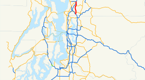
State Route 527 (SR 527, also known as the Bothell – Everett Highway[3]) is a state highway in Snohomish County, of the U.S. state of Washington. It extends 9.23 miles (14.85 km) north from I-405 in the city of Bothell, Washington, to an interchange with Interstate 5 (I-5), SR 99, and SR 526 in Everett, Washington. SR 527 intersects SR 524 and SR 96 before ending in Everett. The route serves as a connector between Bothell, Everett, and Mill Creek.
The highway itself did not fully open until October 17, 1969, and, since its opening, has become increasingly congested, with about 57,000 motorists using the highway at its interchange with I-405 in 2004. A large construction project to widen the highway and put up sound walls ran from 1991-2006. A 2.69-mile-long (4.33 km) section of the route was turned over to local authorities in 2011.
Route description
SR 527 links the cities of Bothell, Everett, and Mill Creek, and intersects two highways: SR 524, and SR 96[4] WSDOT has found that about 46,000 motorists utilize the road daily at I-405 based on average annual daily traffic (AADT) data.[5]
SR 527 starts at a partial cloverleaf interchange with I-405. From the interchange, the road heads northeast to Thrashers Corner, where SR 527 intersects SR 524 before moving on to pass Kennard Corner, Silver Creek Park, North Creek County Park, and Mays Pond Park. The highway then intersects 164th Street SE, a major arterial road, in Mill Creek. Beyond 164th Street SE, the road turns to the north, routing traffic past Mill Creek's town center, Mill Creek Library and Library Park before intersecting a connector to SR 96 westbound. Following the connector, SR 527 intersects SR 96 and runs along the eastern shore of Silver Lake. The route then intersects 112th Street SE, which goes west to the South Everett Freeway Station.[6][7] From 112th Street, the route continues north to the Eastmount Park and Ride, where it turns northwest toward an interchange with I-5 and then to an intersection with SR 99, SR 526, and Broadway, where it terminates. The road continues west from the intersection as SR 526 (also known as the Boeing Freeway), leading to the Boeing Everett Factory, Paine Field, and Mukilteo, Washington. SR 99 runs south from the intersection to the Everett Mall, Seattle, and Fife. An extension of SR 99, Broadway, continues north from the intersection into downtown Everett.[8]
History
In 1923, before the Primary and Secondary system, SR 527 was part of State Road 1, which later became U.S. Route 99 (US 99).[9] In 1937, the route became part of Secondary State Highway 2A (SSH 2A),[10] but was later removed in 1943,[11] and readded as SSH 2J in 1957.[2][12] It went from PSH 2 BO (Bothell branch) in Bothell to SSH 1I and US 99 in Everett.[12] SSH 2J became state highway during the 1964 highway renumbering, in which the Washington State Department of Transportation replaced the previous system of Primary and Secondary Highways with the system of State Routes in use today.[2]
SR 527 officially opened on October 17, 1969,[13] but eventually became overcrowded, with about 57,000 motorists using the road at the I-405 interchange as of 2004.[5] To alleviate congestion, an expansion project began in 1991 that was completed in 2006.[14] The first stage of the project involved widening the road between 228th Street SE and SR-524 to five–seven lanes, as well as minor improvements at its interchange with I-405. The second stage widened the roadway to five lanes between SR 524 and 164th Street, while the third widened the road between 164th Street SE and SR 96.[15] The fourth and most complex stage widened the road between SR 96 and 112th Street SE.[16] This stage involved expanding the SR 527/SR 96 intersection dramatically and raising the roadway near Silver Lake, along with numerous pedestrian and aesthetic improvements.[16][17]
On May 4, 2011, Gov. Christine Gregoire signed into law HB 1520[18] which turned over the responsibility of a 2.69-mile-long (4.33 km) section between I-405 and SR 522 from the state to the City of Bothell. The transferred section will be developed into a suburban multi-way boulevard with pedestrian walkways and bikeways.[19]
Major intersections
The entire highway is in Snohomish County.
| Location | mi[1] | km | Destinations | Notes | |
|---|---|---|---|---|---|
| Bothell | 0.00 | 0.00 | Southern terminus | ||
| 1.05 | 1.69 | ||||
| Mill Creek | 3.93 | 6.32 | |||
| 5.96 | 9.59 | ||||
| Everett | 6.16 | 9.91 | No access to westbound SR 96 | ||
| 7.70 | 12.39 | Access to South Everett Freeway Station | |||
| 9.23 | 14.85 | Northern terminus | |||
| 1.000 mi = 1.609 km; 1.000 km = 0.621 mi | |||||
References
- 1 2 Washington State Department of Transportation. "State Highway Log, 2006" (pdf). Retrieved September 24, 2008.
- 1 2 3 Washington State Legislature. "RCW 47.17.745: State Route 527". Retrieved September 25, 2008.
- ↑ "WSDOT Detours Bothell – Everett Highway Near Silver Lake This Weekend". Washington State Department of Transportation. April 27, 2005. Archived from the original on October 1, 2006. Retrieved October 7, 2008.
- ↑ Everett, Edmonds, Lynnwood (Map) (2007 ed.). City Street Maps. G.M. Johnson. 2007. Retrieved September 26, 2008.
- 1 2 Washington State Department of Transportation (2007). "Washington Annual Average Daily Traffic Data" (PDF). Retrieved September 26, 2008.
- ↑ Washington State Department of Transportation. "I-5 - South Everett Freeway Station / 112th Street SE Project". Retrieved September 27, 2008.
- ↑ Sound Transit. "South Everett Freeway Station Project". Retrieved September 27, 2008.
- ↑ Google (July 21, 2015). "State Route 527" (Map). Google Maps. Google. Retrieved July 21, 2015.
- ↑ Washington State Legislature (1923). "185". Session Laws of the State of Washington. Session Laws of the State of Washington (1923 ed.). Olympia, Washington: Washington State Legislature. Retrieved September 27, 2008.
- ↑ Washington State Legislature (1937). "190". Session Laws of the State of Washington. Session Laws of the State of Washington (1937 ed.). Olympia, Washington: Washington State Legislature. Retrieved September 27, 2008.
- ↑ Washington State Legislature (1943). "207". Session Laws of the State of Washington. Session Laws of the State of Washington (1943 ed.). Olympia, Washington: Washington State Legislature. Retrieved August 10, 2008.
- 1 2 Washington State Legislature (1957). "172". Session Laws of the State of Washington. Session Laws of the State of Washington (1957 ed.). Olympia, Washington: Washington State Legislature. Retrieved August 10, 2008.
- ↑ David A. Cameron; Lynne Grimes; Jane Wyatt (2005). "Chapter 11: 1965-2004". Snohomish County: An Illustrated History. Index, Washington: Kelcema Books. p. 338. ISBN 0-9766700-0-3.
- ↑ "SR 527 - Corridor Improvements". Washington State Department of Transportation. Archived from the original on December 30, 2006. Retrieved September 26, 2008.
- ↑ "SR 527 - Corridor Widening - 164th Street SE to 132nd Street SE (SR 96)". Washington State Department of Transportation. Archived from the original on December 31, 2006. Retrieved September 26, 2008.
- 1 2 "SR 527 - Corridor Widening - 132nd Street SE (SR 96) to 112th Street SE". Washington State Department of Transportation. Archived from the original on October 4, 2006. Retrieved September 26, 2008.
- ↑ Federal Highway Administration. "Environmental Review Toolkit - Streamlining and Stewardship - Search Results (see #5)". Retrieved September 27, 2008.
- ↑ "HB 1520 - 2011-12". Retrieved May 5, 2011.
- ↑ "Moscoso Bills Signed by Governor". Retrieved May 5, 2011.
External links
- Highways of Washington State
- Washington State Department of Transportation: SR 527 - Corridor Improvements
- Traffic camera for SR 527 – 164th Street Intersection (WSDOT)
- Traffic camera for SR 527 – I-405 Interchange (WSDOT)