Washington State Route 504
| ||||
|---|---|---|---|---|
| Spirit Lake Memorial Highway | ||||
|
SR 504 highlighted in red. | ||||
| Route information | ||||
| Auxiliary route of I‑5 | ||||
| Defined by RCW 47.17.655 | ||||
| Maintained by WSDOT | ||||
| Length: | 51.76 mi[1] (83.30 km) | |||
| Existed: | 1964[2] – present | |||
| Major junctions | ||||
| West end: |
| |||
|
| ||||
| Eastern end: | Johnston Ridge Observatory in Mount St. Helens NVM | |||
| Highway system | ||||
| ||||

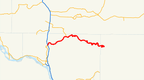
State Route 504 (SR 504, also known as the Spirit Lake Memorial Highway[2]) is a state highway in Cowlitz and Skamania counties, in the U.S. state of Washington. It extends 51.76 miles (83.30 km) from an interchange with Interstate 5 (I-5), SR 411 and Interstate 5 Business (I-5 Bus) in the city of Castle Rock, east to end at the Johnston Ridge Observatory. The route serves as a connector from Castle Rock to Mount St. Helens NVM.
The highway was Secondary State Highway 1R (SSH 1R) from 1937 until 1964. SSH 1R ran from Castle Rock to the border of the Columbia National Forest (now known as the Gifford Pinchot National Forest) from 1937 until 1961. In 1961, the Washington State Legislature extended SSH 1R east to Spirit Lake. In 1964, SSH 1R became SR 504. When Mount St. Helens erupted on May 18, 1980, SR 504 was closed and was heavily damaged from SR 505 to Spirit Lake. The highway was rebuilt and partially opened in 1991 on a higher and safer route to Coldwater Ridge. The new highway was completed when the road to the Johnston Ridge Observatory was opened in 1994.
SR 504 also has a spur route, named SR 504 Spur, that runs along the former route of SR 504 in the Gifford Pinchot National Forest. The route extends 0.87 miles (1.40 km) along the former route of SR 504, before the Mount St. Helens eruption. Parts of the highway closes every winter due to snow and the risk of avalanches.[3]
Route description
SR 504 runs 51.76 miles (83.30 km) from an interchange with Interstate 5 (I-5), SR 411 and Interstate 5 Business (I-5 Bus) in the city of Castle Rock, east to end at the Johnston Ridge Observatory.[4][5] The route serves as a connector from Castle Rock to Mount St. Helens NVM.[4] WSDOT has found that more than 14,000 motorists utilize the road daily after the interchange with I-5 based on average annual daily traffic (AADT) data.[6]
Castle Rock to Kid Valley

SR 504 starts at an interchange with I-5, SR 411 and I-5 Business north of Downtown Castle Rock.[7] 0.15 miles (0.24 km) after the interchange, the highway intersects the Old Pacific Highway,[1] which used to be U.S. Route 99.[8] The road turns north after the intersection and leaves Castle Rock 0.51 miles (0.82 km) north of the interchange.[1] After turning back east, the road goes south again to turn east towards Seaquest State Park, a 475 acres (1.92 km2) state park,[9] located 5.25 miles (8.45 km) east of Castle Rock.[1] After passing the state park, SR 504 starts to parallel the shoreline of Silver Lake and passes the community of Silverlake.[4]
The highway stops paralleling the shoreline of Silver Lake after passing the Silver Lake Cemetery on the north side of the road. SR 504 continues northeast to Toutle, where the highway crosses the Toutle River.[1] After crossing the river and leaving Toutle, the highway intersects SR 505's eastern terminus. The road then crosses the North Fork of the Toutle River and enters Kid Valley, Washington.[4]
Kid Valley to Johnston Ridge

After leaving Kid Valley, SR 504 intersects SR 504 Spur, which follows the older route of SR 504 before the eruption 0.87 miles (1.40 km) to a viewpoint.[1]
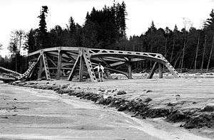
After crossing the North Fork of the Toutle River once more, the highway crosses Hoffstadt Creek on the Hoffstadt Creek Bridge, a 2,340 feet (713.23 m) long and 370 feet (112.78 m) high bridge built after the eruption,[10] one of 14 new bridges.[10] About 3.37 miles (5.42 km) after the bridge, the road passes the Forest Learning Center and follows the northern boundary of the Mount St. Helens NVM before actually entering it.[4]
After entering the National Monument, SR 504 splits and has a partial cloverleaf interchange with itself. The westbound lanes are known as State Route 504 Loop.[1] After the interchange, the highway curves twice down a cliff and starts to run along the shoreline of Coldwater Lake. After looping back northeast, the road leaves Cowlitz County and enters Skamania County. SR 504 then goes east to its easternmost point and curves back west to the Johnston Ridge Observatory.[4][11]
Former route
About 21.03 miles (33.84 km) east of Castle Rock, the new alignment of SR 504 starts.[1][12] The old route is now known for the first 0.87 miles (1.40 km) of the route as SR 504 Spur.[1] SR 504 Spur goes from SR 504 to a viewpoint.[1][13] Then, the old route goes east along the North Fork of the Toutle River passing the abandoned community of St. Helens before crossing the river.[12] The highway then went east along the shoreline of Spirit Lake to the community of Spirit Lake and then south to Mount St. Helens.[12]
History
1937 – 1980

When the Primary and Secondary Highways were created in 1937, the former route of SR 504 became Secondary State Highway 1R (SSH 1R).[14] SSH 1R ran from Primary State Highway 1 (PSH 1) and SSH 12H in Castle Rock east past SSH 1Q to the border of the Columbia National Forest,[15] now known as Gifford Pinchot National Forest,[15] in 1937.[14]
In 1961, the Washington State Legislature extended SSH 1R east to Spirit Lake.[16] SSH 1R became SR 504 in 1964 during the 1964 highway renumbering, in which the Washington State Department of Transportation (WSDOT) replaced the previous system of Primary and Secondary Highways with a new system called State Routes, which is still in use today.[17][18] From 1964 until 1980, SR 504 ran along the shores of the North Fork of the Toutle River,[12] but was rerouted to partially follow Bear Creek.[12]
1980 – 2001
On May 18, 1980, Mount St. Helens erupted after two months of small earthquakes and pre-avalanche eruptions.[19] SR 504 was heavily damaged after the eruption from floodwaters and was closed for reconstruction.[19] In 1982, the Washington State Legislature named SR 504 the Spirit Lake Memorial Highway in honor of Spirit Lake and the 57 people killed by the eruption.[2][20]
After the highway was reconstructed on a route farther from the river, it partially opened from SR 505 to Coldwater Ridge in 1991. Later, in 1994, it officially opened from Coldwater Ridge to the Johnston Ridge Observatory; Coldwater Ridge was later named Johnston Ridge to honor volcanologist David A. Johnston,[21] who perished there observing the eruption.[22][23] Also in 1994, five new tourist centers were being planned because of a boost in tourism.[24] The United States Forest Service planned three, Cowlitz County and Weyerhaeuser each planned one.[24]
2001 – present
In 2001, a proposal for a highway connecting SR 504 to National Forest Route 99 on the eastern part of the mountain was started.[25] The highway was proposed to be 7 miles (11 km) long going through an area known as Pumice Plain and would cost $20 million USD.[25] WSDOT repaved SR 504 from Castle Rock to the Toutle River Bridge in 2003.[26]
From 2004 until 2006, Mount St. Helens started having magma seep onto the surface and small ash plumes rise.[27][28] In March 2007, WSDOT completely closed SR 504 from Kid Valley to Johnston Ridge because of an unstable slope about 19.9 miles (32.0 km) east of Castle Rock.[29][30] The highway later opened to traffic on April 2, 2007.[31] WSDOT closes parts of SR 504 during the winter every year and reopens by spring.[3]
Sometimes certain portions of the road are closed and reopened, such as Cow Creek,[32] Bear Creek,[33] and the Coldwater Visitor Center.[34] During 2008, with snow going into April, SR 504 did not open until May 16.[35][36]
Major intersections
| County | Location | mi[1] | km | Destinations | Notes |
|---|---|---|---|---|---|
| Cowlitz | Castle Rock | 0.00 | 0.00 | Western terminus | |
| 0.15 | 0.24 | Old Pacific Highway | Formerly US 99 | ||
| | 14.69 | 23.64 | Eastern terminus of SR 505 | ||
| Gifford Pinchot NF | 21.03 | 33.84 | Former SR 504 (1964 – 1980) | ||
| Mount St. Helens NVM | 44.32 | 71.33 | Entering Mount St. Helens National Volcanic Monument | ||
| Skamania | 51.76 | 83.30 | Johnston Ridge Observatory | Eastern terminus | |
| 1.000 mi = 1.609 km; 1.000 km = 0.621 mi | |||||
Spur route
| |
|---|---|
| Location: | Gifford Pinchot NF |
| Existed: | 1991–present |
State Route 504 Spur (SR 504 Spur) is the spur route of SR 504 located within Gifford Pinchot National Forest.[13] The route extends 0.87 miles (1.40 km) along the former route of SR 504, before the Mount St. Helens eruption.[1] WSDOT has found that more than 90 motorists utilize the road daily based on average annual daily traffic (AADT) data.[6] The road connects to a viewpoint and the spur's full name from WSDOT is State Route 504 Spur Old504.[1] The spur is known as Stuart Dam Road for its entire length.[1]
Major intersections
The entire highway is in Cowlitz County.
| Location | mi[1] | km | Destinations | Notes | |
|---|---|---|---|---|---|
| Gifford Pinchot NF | 0.00 | 0.00 | Western terminus | ||
| 0.87 | 1.40 | Viewpoint | Eastern terminus | ||
| 1.000 mi = 1.609 km; 1.000 km = 0.621 mi | |||||
References
- 1 2 3 4 5 6 7 8 9 10 11 12 13 14 15 Washington State Department of Transportation. "State Highway Log, 2006" (PDF). Retrieved November 17, 2008.
- 1 2 3 Washington State Legislature. "RCW 47.17.655: State Route 504". Retrieved November 17, 2008.
- 1 2 Arola, Sam; Sarah Druffel (November 29, 2007). "SR 504 Near Coldwater Lake Closed for Winter Season, Starting November 29". Washington State Department of Transportation. Archived from the original on January 16, 2009. Retrieved November 17, 2008.
- 1 2 3 4 5 6 Google (October 18, 2015). "State Route 504" (Map). Google Maps. Google. Retrieved October 18, 2015.
- ↑ Kelso, Longview, Centralia, Chehalis (Map) (2008 ed.). City Street Maps. G.M. Johnson. 2008. Retrieved November 17, 2008.
- 1 2 Washington State Department of Transportation (2007). "Washington Annual Average Daily Traffic Data" (PDF). Retrieved November 17, 2008.
- ↑ Washington State Department of Transportation (November 4, 1998). "SR 5 / SR 411 / SR 504 / SR 5 Bus (I-5 Exit 49) Interchange Diagram" (PDF). Archived from the original (PDF) on October 8, 2006. Retrieved November 17, 2008.
- ↑ Junior Auto Road Map (Map). 1,500,000. Rand McNally. 1927. pp. 82–83 (Washington). Retrieved November 17, 2008.
- ↑ Washington State Parks. "Seaquest State Park". Retrieved November 17, 2008.
- 1 2 photo2c (October 22, 2008). "State Route 504 – Hoffstadt Creek Bridge". Washington State Department of Transportation; Flickr. Retrieved November 17, 2008.
- ↑ Official State Highway Map (PDF) (Map) (2008-2009 ed.). 1:842,000. Official State Highway Maps. Cartography by U.S. Geological Survey. Olympia, Washington: Washington State Department of Transportation. 2008. § G3. Retrieved November 17, 2008.
- 1 2 3 4 5 John Means Whatever (October 7, 2007). "State Route 504 – Spirit Lake Memorial Highway". Washington State Department of Transportation; Flickr. Retrieved November 17, 2008.
- 1 2 Google (October 18, 2015). "State Route 504 Spur" (Map). Google Maps. Google. Retrieved October 18, 2015.
- 1 2 Washington State Legislature (1937). "207". Session Laws of the State of Washington. Session Laws of the State of Washington (1937 ed.). Olympia, Washington: Washington State Legislature. p. 997. Retrieved November 9, 2008.
- 1 2 Davis, Richard C. (September 29, 2005). "National Forests of the United States" (PDF). The Forest History Society. Archived from the original (PDF) on February 12, 2013. Retrieved November 17, 2008.
- ↑ Washington State Legislature (1961). "21". Session Laws of the State of Washington. Session Laws of the State of Washington (1961 ed.). Olympia, Washington: Washington State Legislature. p. 2620. Retrieved November 9, 2008.
- ↑ C. G. Prahl, Washington State Highway Commission (December 1, 1965). "Identification of State Highways, Part 1" (PDF).
- ↑ C. G. Prahl, Washington State Highway Commission (December 1, 1965). "Identification of State Highways, Part 2" (PDF).
- 1 2 Washington State Department of Transportation. "WSDOT – Centennial Timeline – Shifting Gears: 1978 – 1990". Archived from the original on August 30, 2008. Retrieved November 17, 2008.
- ↑ Washington State Legislature (1982). "82". Session Laws of the State of Washington. Session Laws of the State of Washington (1982 ed.). Olympia, Washington: Washington State Legislature.
- ↑ Find A Grave (January 4, 2005). "David Alexander Johnston". Retrieved November 17, 2008.
- ↑ U.S. Geological Survey (1982). "David A. Johnston: December 1949 - May 18, 1980". Retrieved November 17, 2008.
- ↑ LaFee, Scott (December 3, 2003). "Perish the thought: A life in science sometimes becomes a death, too". The San Diego Union-Tribune. Retrieved November 17, 2008.
- 1 2 "Five Tourist Centers Planned For Mount St. Helens By 1996". The Seattle Times. May 19, 1994. Retrieved November 17, 2008.
- 1 2 Larson, Douglas W. (May 10, 2001). "Don't build a highway at Mount St. Helens". The Seattle Times. Retrieved November 17, 2008.
- ↑ Washington State Department of Transportation. "SR 504 – Castle Rock to Toutle River Bridge Repaving". Archived from the original on August 29, 2008. Retrieved November 17, 2008.
- ↑ U.S. Geological Survey. "USGS before and after images". Retrieved November 17, 2008.
- ↑ "Mount St. Helens, Washington, "Plume in the Evening"". U.S. Geological Survey. March 8, 2005. Retrieved November 17, 2008.
- ↑ Arola, Sam; Sarah Druffel (March 26, 2007). "Complete Closure, State Route 504 East of Kid Valley Due to an Unstable Slope". Washington State Department of Transportation. Archived from the original on September 7, 2008. Retrieved November 17, 2008.
- ↑ Arola, Sam; Sarah Druffel (March 29, 2007). "Work to Remove Debris from State Route 504, East of Kid Valley, Begins March 29". Washington State Department of Transportation. Archived from the original on October 6, 2008. Retrieved November 17, 2008.
- ↑ Arola, Sam; Sarah Druffel (April 2, 2007). "Major Debris Clean-Up Complete, SR 504 East of Kid Valley Opens to Traffic". Washington State Department of Transportation. Archived from the original on May 20, 2007. Retrieved November 17, 2008.
- ↑ Kufstad, Bob; Sylvia Ross (December 26, 2007). "SR 504 at Cow Creek Closes Temporarily Due to Snow". Washington State Department of Transportation. Archived from the original on July 5, 2008. Retrieved November 17, 2008.
- ↑ Arola, Sam; Sarah Druffel (January 29, 2008). "SR 504 at Bear Creek Closes Temporarily Due to Snow". Washington State Department of Transportation. Archived from the original on July 6, 2008. Retrieved November 17, 2008.
- ↑ Arola, Sam; Annie Linstrom (March 20, 2008). "SR 504 to Coldwater Visitor Center Reopens on Thursday, March 20". Washington State Department of Transportation. Archived from the original on June 28, 2008. Retrieved November 17, 2008.
- ↑ "Observatory to open for 1980 Mount St. Helens eruption". The Seattle Times. May 15, 2008. Retrieved November 17, 2008.
- ↑ Fiman, Alice; Nisha Marvel; Susan Harris-Huether; Tonia Buell (May 19, 2008). "WSDOT Driver Tip: US 2, Snoqualmie Pass, I-5 busy on Memorial Day Weekend". Washington State Department of Transportation. Archived from the original on November 12, 2008. Retrieved November 17, 2008.
External links
 Media related to Washington State Route 504 at Wikimedia Commons
- Highways of Washington State
- West Coast Roads
- Washington State Department of Transportation: SR 504 – Castle Rock to Toutle River Bridge