Weather lore
Weather lore is the body of informal folklore related to the prediction of the weather.
It has been a human desire for millennia to make accurate weather predictions. Oral and written history is full of rhymes, anecdotes, and adages meant to guide the uncertain in determining whether the next day will bring fair or foul weather. For the farmer wanting to plant crops, for the merchant about to send ships on trade, foreknowledge of tomorrow's circumstances might mean the difference between success and failure. Prior to the invention of the mercury barometer, it was very difficult to gather numerical data of any predictive value. Even though there were devices such as the weather stick which gave some indication of moisture changes, the only instrument of any reliability was human experience.[1][2]
Where weather happens
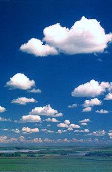
It is in Earth's middle latitudes, between roughly 30° to 60° North and South, that a significant portion of "weather" can be said to happen, that is, where meteorological phenomena do not persist over the long term, and where it may be warm, sunny, and calm one day, and cold, overcast and stormy the next.
A great percentage of the world's population lives in the equatorial regions,[3] but for the most part, these regions do not experience weather as it is understood by this definition. The Sahara Desert in northern Africa, for instance, is almost uniformly hot, sunny and dry all year long especially due to the non-stop presence of high atmospheric pressure aloft, whereas weather trends on the Indian subcontinent and in the western Pacific, for instance, the monsoonal belt, occur gradually over the very long term, and the diurnal weather patterns remain constant.
Weather folklore, therefore, refers to this mid-latitude region of daily variability. While most of it applies equally to the Southern Hemisphere, the Southern Hemisphere resident may need to take into account the fact that weather systems rotate opposite to those in the North. For instance, the "crossed winds"[4] rule (see below) must be reversed for the Australian reader.
Sayings which may be locally accurate
Folkloric content usually has some locally based observational validity which allows these sayings to stand the test of time. Some of these observations may even have scientific explanations.
When Clouds Look Like Black Smoke
- When Clouds Look Like Black Smoke
- A Wise Man Will Put On His Cloak
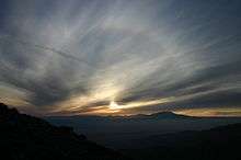
Red sky at night
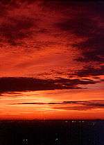
(See also Red sky at morning)
- Red sky at night, sailor's delight.
- Red sky in the morning, sailor's warning.
(In some variations, 'sailor' is replaced by 'shepherd')
A red sky - in the morning or evening, is a result of high pressure air in the atmosphere trapping particles of dust or soot. Air molecules scatter the shorter blue wavelengths of sunlight, but particles of dust, soot and other aerosols scatter the longer red wavelength of sunlight in a process called Rayleigh scattering. At sunrise and sunset, the sun is lower in the sky causing the sunlight to travel through more of the atmosphere so scattering more light.[5] This effect is further enhanced when there are at least some high level clouds to reflect this light back to the ground.[6]
When weather systems predominantly move from west to east. A red sky at night indicates that the high pressure air (and better weather) is westwards. In the morning the light is eastwards, and so a red sky then indicates the high pressure (and better weather) has already passed, and an area of low pressure is following behind.[7]
Low pressure regions
- When the wind is blowing in the North
- No fisherman should set forth,
- When the wind is blowing in the East,
- 'Tis not fit for man nor beast,
- When the wind is blowing in the South
- It brings the food over the fish's mouth,
- When the wind is blowing in the West,
- That is when the fishing's best!
In western European seas, this description of wind direction is an excellent illustration of how the weather events of an active low pressure area[8] present themselves. With the approach of a low, easterly winds typically pick up. These gusty winds can be unpleasant for a number of reasons; they are often uncomfortably warm, dry, and dusty in the summer and bitterly cold in the winter. Northerly winds, which follow around a low, are cold and blustery. Sailing in conditions of northerly winds requires expertise and a boat capable of handling heavy waves. Southerly winds usually bring warm temperatures, and though they may not necessarily feed the fish, they do provide pleasant fishing weather. The best circumstance, however, is to have a westerly wind blowing; the wind condition is likely to persist for some time, the weather should remain fair and clear, and the wind should be relatively constant.
Wind and weather observations will be different for a low passing to the north of the observer than for one passing to the south. When a low passes to the north, the winds typically pick up from the east, swing to southerly (possibly accompanied by light precipitation, usually not) with the passage of the low's warm front, and then switch to northwesterly or westerly as the cold front passes. Typically, if there is any heavy precipitation, it will accompany the passage of the cold front. When a low passes to the south, on the other hand, winds will initially pick up from the east, but will gradually shift to northerly. Overcast skies and steady precipitation often occur as the center of the low passes due south, but skies will clear and winds will gradually become westerly as the low moves off to the east. No observer will experience all the weather elements of a low in a single passage.[9]
Calm conditions
- No weather is ill, if the wind be still.
Calm conditions, especially with clear skies, indicate the dominance of a high pressure area. Because highs are broad regions of descending air, they discourage the formation of phenomena typically associated with weather, such as clouds, wind, and precipitation. Calm conditions, though, may also result from a circumstance known as "the calm before the storm," in which a large thunderstorm cell to the west may be updrafting the westerly surface wind before it can arrive locally. This situation is readily identifiable by looking to the west — such an approaching storm will be close enough to be unmistakable. In winter, though, calm air and clear skies may signal the presence of an Arctic high,[10] typically accompanied by very cold air, and it is difficult to imagine describing a temperature of -35 °C as pleasant.
Bird Behavior
Sometimes the lore is concurrent with existing conditions, more than prediction, as in:
Seagulls tend to sleep on the water. However, seagulls, like people, find gusty, turbulent wind difficult to contend with, and under such circumstances, the water is also choppy and unpleasant. Seagulls huddled on the ground may be a sign that the weather is already bad.
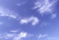
A ring around the moon
- When halo rings the moon or sun, rain's approaching on the run
 Solar halo is precursor to rain |
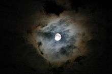
A halo around the sun or moon is caused by the refraction of that body's light by ice crystals at high altitude. Such high-level moisture is a precursor to moisture moving in at increasingly lower levels, and is a good indicator that an active weather system is on its way. Halos typically evolve into what is known as "milk sky", when the sky appears clear, but the typical blue is either washed-out or barely noticeable. This high, thick cirrostratus cloud is a clear indicator of an approaching low. In the coldest days of winter, a halo around the sun is evidence of very cold and typically clear air at and above the surface. But sun dogs are indicators that weather conditions are likely to change in the next 18 to 36 hours.[11]
Humidity indicators
Moisture in the air causes wood to swell, making doors and windows sticky, and salt is a very effective absorber of moisture. With a high level of moisture in the air, the likelihood of precipitation is increased. The magnesium carbonate and later calcium silicate in iodized salt acts as an anti-clumping agent in humid conditions, leading to Morton Salt's umbrella girl logo and slogan "When it rains, it pours".
Pasture-watching

- A cow with its tail to the West makes the weather best,
- A cow with its tail to the East makes the weather least
Cows prefer not to have the wind blowing in their faces, and so typically stand with their backs to the wind. Since westerly winds typically mean arriving or continuing fair weather and easterly winds usually indicate arriving or continuing unsettled weather, a cowvane is as good a way as any of knowing what the weather will be up to for the next few hours.
Fog
Fog is formed when the air cools enough that the vapor pressure encourages condensation over evaporation. In order for the air to be cool on a summer night, the sky must be clear, so excess heat can be radiated into space. Cloudy skies act like a blanket, absorbing and reradiating the heat, keeping it in. So if it is cool enough (and clear enough) for fog to form, it will probably be clear the next day. Winter fog is the result of two entirely different circumstances. Above the ocean or a large lake, air is typically more humid than above land. When the humid air moves over cold land, it will form fog and precipitation. (To the east of the North American Great Lakes, this is a common phenomenon, and is known as the "lake effect.")[12] In northerly climates, ice fog may form when the temperature drops substantially below freezing. It is almost exclusively an urban phenomenon, when the air is so cold that any vapor pressure results in condensation, and additional vapor emitted by automobiles, household furnaces, and industrial plants simply accumulates as fog.
Sound transmission
- When sounds travel far and wide,
- A stormy day will betide.
This piece of lore is true in summer but conditionally false in winter. Moisture-laden air is a better conductor of sound than dry air, so moist air carries sounds farther. In winter, temperature also becomes an important factor. If the air is warm and moist, the rule holds. If the air is very cold, it is also very dense and a better sound conductor than warm air, and also likely to be much drier. When sounds carry over a long distance, the cold, clear weather is likely to linger.
Cloud movement
- If clouds move against the wind, rain will follow.
This rule may be true under a few special circumstances, otherwise it is false. By standing with one's back to the ground-level wind and observing the movement of the clouds, it is possible to determine whether the weather will improve or deteriorate.[9] For the Northern Hemisphere, it works like this: If the upper-level clouds are moving from the right, a low-pressure area has passed and the weather will improve; if from the left, a low pressure area is arriving and the weather will deteriorate. (Reverse for the Southern Hemisphere.) This is known as the "crossed-winds" rule.[4] Clouds traveling parallel to but against the wind may indicate a thunderstorm approaching. Outflow winds typically blow opposite to the updraft zone, and clouds carried in the upper level wind will appear to be moving against the surface wind. However, if such a storm is in the offing, it is not necessary to observe the cloud motions to know rain is a good possibility. The nature of airflows directly at a frontal boundary can also create conditions in which lower winds contradict the motions of upper clouds, and the passage of a frontal boundary is often marked by precipitation. Most often, however, this situation occurs in the lee of a low pressure area, to the north of the frontal zones and convergence region, and does not indicate a change in weather, but rather, that the weather, fair or showery, will remain so for a period of hours at least.[9]
Aches and pains
- A coming storm your shooting corns presage,
- And aches will throb, your hollow tooth will rage.
There have been medical studies done which indicate some people experience this effect. The most likely reason is that with a fall in atmospheric pressure, blood vessels dilate slightly in reaction. This has the effect of aggravating already-irritated nerves near corns, cavities, or arthritic joints.[13] Studies are inconclusive, however, with some researchers attributing this effect to selective memory.
False lore, and why
One of the problems in testing the veracity of traditions about the weather is the wide variety to be found in the details of sayings and traditions. Some variations are regional, while others exhibit less of a pattern.
Groundhogs
- If on February 2 (Groundhog Day in the United States and Canada) the groundhog sees its shadow, thirty days of winter remain. If not, spring will follow immediately.
Annual records show that the groundhog prediction is not correct beyond chance.[14] In other words, there is no correlation between cloud cover on that day, and the imminence of springlike weather.
Lion and Lamb
An English proverb describes typical March weather: (A Common Pennsylvania Saying)
In Wales this proverb is applied to the month of April more often than March, especially in the borders.
In the 19th century it was used as a prediction contingent on a year's early March weather:
but it was recognized to not work well.
The reverse is true as well. If the weather is nice early, it comes in like a lamb and will go out like a lion.
Early-morning rain
- Rain before seven, clear by eleven.
Late-night rains and early morning rains may simply be the last precipitation of a passing weather front. However, since fronts pass at night as often as they do in the day, morning rain is no predictor of a dry afternoon. However, this lore can describe non-frontal weather. Given sufficient surface heating, a late-day rainstorm may continue to develop into the night, produce early precipitation, then dissipate by late morning. This, though, is the exception rather than the rule. Only 40% of rain is produced by convective events—60% is the result of a frontal passage.[17]
March thunderstorms
"Blows its horn" refers to thunderstorms. While March thunderstorms indicate that the weather is unusually warm for that time of year (thunderstorms can occur only with a sufficiently large temperature difference between ground and sky and sufficient amounts of moisture to produce charge differential within a cloud),[18] it is no indicator of the long-term weather trend. It is still unwise to plant your annuals before the long May weekend.
Pets eating grass
- Cats and dogs eat grass before a rain.
While it is true that cats and dogs eat grass, it has nothing to do with the weather and is because cats and dogs are not exclusively carnivorous. Some researchers believe that dogs eat grass as an emetic when feeling ill.[19]
Onion skins
- Onion skins very thin
- Mild winter coming in;
- Onion skins thick and tough
- Coming winter cold and rough.[20]
This verse, and so many others like it, attempts to predict long-range conditions. These predictions have stood the test of time only because they rely on selective memory: people remember when they have predicted correctly and forget when predictions don't hold. One possible factor which could provide these predictions with a thin edge of credibility is that there is some degree of consistency in weather from year to year. Drought cycles or El Niño winters are a perfect example of such circumstances. A pattern of cool summers and warm winters, for instance, can produce patterns in other natural events sensitive enough to be affected by changes in temperature or precipitation.
Special weather-forecasting days
In the British Isles, Saint Swithun's day (July 15) is said to forecast the weather for the rest of the summer. If St Swithun's day is dry, then the legend says that the next forty days will also be dry: "St.Swithin’s Day if thou be fair, 'Twill rain for forty days no mair; St. Swithin’s Day if thou dost rain, For forty days it will remain.". If however it rains, the rain will continue for forty days. In France, Saint Medard (June 8), Urban of Langres (April 2), and Saint Gervase and Saint Protais (June 19) are credited with an influence on the weather almost identical with that attributed to St Swithun in England, while in Flanders there is St Godelieve (July 6) and in Germany the Seven Sleepers Day (June 27).
There is a scientific basis to the legend of St Swithun's day. Around the middle of July, the jet stream settles into a pattern which, in the majority of years, holds reasonably steady until the end of August. When the jet stream lies north of the British Isles then continental high pressure is able to move in; when it lies across or south of the British Isles, Arctic air and Atlantic weather systems predominate.[21]
In Russia, the weather on the feast of the Protecting Veil is popularly believed to indicate the severity of the forthcoming winter.[22]
There was an old proverb from Romagna that ran: "Par San Paternian e' trema la coda a e' can." ("On St. Paternian's day, the dog's tail wags"). This Cervian proverb refers to the fact that the cold began to be felt around the saint's feast day. A farmers' saying associated with Quirinus' feast day of March 30 was "Wie der Quirin, so der Sommer" ("As St. Quirinus' Day goes, so will the summer").[23]
The Ice Saints is the name given in German, Austrian, and Swiss folklore to a period noted to bring a brief spell of colder weather in the Northern Hemisphere under the Julian Calendar in May, because the Roman Catholic feast days of St. Mamertus, St. Pancras, and St. Servatus fall on the days of May 11, May 12, and May 13 respectively.
References
- 1 2 WXSYS (retrieved 2007 February 15)
- ↑ aqua.nasa.gov (retrieved 2007 February 15)
- ↑ United States Department of Agriculture (retrieved 2006 November 27)
- 1 2 Sailnet.com (Retrieved 2006 April 24)
- ↑ http://www.esrl.noaa.gov/gmd/grad/about/redsky/
- ↑ http://www.spc.noaa.gov/publications/corfidi/sunset/
- ↑ http://www.metoffice.gov.uk/learning/learn-about-the-weather/how-weather-works/red-sky-at-night
- ↑ Morehead Planetarium and Science Centre (Retrieved 2006 April 24)
- 1 2 3 Instant Weather Forecasting in Canada - Alan Watts (Library of Congress #68-9173)
- ↑ nsidc.colorado.edu (retrieved 2007 February 26)
- ↑ The Weather Network (retrieved 2007 February 15)
- ↑ The Weather Doctor (Retrieved 2006 April 24)
- ↑ Massachusetts Technology Transfer Center (retrieved 2006 November 27)
- ↑ NOAA (Retrieved 2006 April 24)
- ↑ Thomas Fuller (1732). Gnomologia. B. Barker.
- ↑ Punch v. 48. Tom Taylor. 1865.
- ↑ Alberta Agriculture (retrieved 2007 February 26)
- ↑ uwsp.edu (retrieved 2007 February 26)
- ↑ Petstyle.com (retrieved 2007 February 15)
- ↑ About Onions: Quotes (retrieved 2006 November 27)
- ↑ Tom Coghlan Last updated at 12:01AM, April 16, 2012. "The Times, Follow St Swithin: book a British break". Timesonline.co.uk. Retrieved 2012-04-16.
- ↑ wscsd.org (retrieved 2006 November 27)
- ↑ Quirinus von Rom (von Neuss) - Ökumenisches Heiligenlexikon
Further reading
- Bill Giles. The Story of Weather. ISBN 0-11-400355-6).
External links
- Weather lore and proverbs
- Skywatch - Signs of the Weather
- (Spanish) ParemioRom - Weather proverbs in the Romance languages