Weedon Bec
| Weedon Bec | |
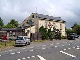
 The Crossroads public house |
|
 Weedon Bec |
|
| Population | 2,706 (2011 Census) |
|---|---|
| OS grid reference | SP629596 |
| – London | 68 miles (109 km) |
| Civil parish | Weedon Bec |
| District | Daventry district |
| Shire county | Northamptonshire |
| Region | East Midlands |
| Country | England |
| Sovereign state | United Kingdom |
| Post town | NORTHAMPTON |
| Postcode district | NN7 |
| Dialling code | 01327 |
| Police | Northamptonshire |
| Fire | Northamptonshire |
| Ambulance | East Midlands |
| EU Parliament | East Midlands |
| UK Parliament | Daventry |
|
|
Coordinates: 52°13′52″N 1°04′50″W / 52.23101°N 1.08045°W
Weedon Bec usually just called Weedon, is a large village and parish in the district of Daventry, Northamptonshire, England. It lies close to the source of the River Nene. The population of the civil parish at the 2011 Census was 2,706.[1]
Geography

Weedon is located about 6 miles (9.7 km) south-east of Daventry, 7 miles (11.3 km) west of Northampton and is at the crossroads of the A5 and A45 main roads. The Grand Union Canal (1796) and West Coast Main Line both pass through the village. The village station, just north of the A45 road bridge closed in the 1960s. Between 1888 and 1963 there was a branch line just north of Weedon to Leamington Spa via Daventry. Although a 'Northampton Parkway' or 'Daventry Parkway' railway station on the site of the former station has been mooted from time to time, there have never been any firm plans.
Lower Weedon and Upper Weedon are to the south of the village. The northern boundary of the village follows the A45 to the west, then south to just outside Everdon, then skirts Everdon Wood and Everdon Stubbs, and borders Stowe Nine Churches to the south-east, and lies to a short distance east of the A5 up to the A45, next to Flore parish. To the south of the parish is the 162m Weedon Hill. The village is close to the boundary of South Northamptonshire and Daventry district.
Weedon Lois or Lois Weedon is in a different part of the county.
The name came from the Old English "Wēo-dūn" meaning "Temple Hill". Before the Christian era there may have been a heathen temple here.
Demographics
The 2001 census[2] it had a population of 2,485, 1,248 male and 1,237 female, 1,237 households and average age 38.34 years. The population at the 2011 Census was 2,706.
History
The village[3] is usually called just "Weedon" when including "Lower Weedon" and "Upper Weedon" which were once distinct villages now merged into one. The settlement patterns of all three villages have been distorted by the presence of the major road, the canal, the military establishments and the railway station and present an unusual example of urban sprawl in an otherwise rural part of England. The area on the A5, the Roman road of Watling Street from London to Holyhead was known as "Road Weedon" and earlier "Weedon on the Street". The "Bec" part of the name is derived from the Abbey of Bec-Hellouin, in Normandy, France, which owned most of the village until the dissolution of the monasteries, when King Henry VIII gave it to Eton College.
Experiments with radar in 1935
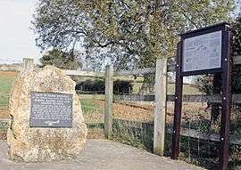
Arnold Frederic Wilkins demonstrated radar, from radio waves from the Borough Hill transmitter on 26 February 1935. It is often stated as taking place near Weedon Bec, but actually took place in a field just off the A5, towards Litchborough, in the parish of Stowe Nine Churches (Upper Stowe).
A memorial to the event is located off the A5 just south of Weedon on the Litchborough Road (NGR SP650557).
On 26 February 2010 the event was re-enacted 75 years after the event. This was done by radio amateurs from the Coventry Amateur Radio Society and the Northampton Radio Club. A working RADAR set was constructed using the two-metre amateur radio band. As with the original experiment the source signal was transmitted from Borough Hill in Daventry. The four target aircraft were flown by pilots with amateur radio licences.
Weedon rail crashes
Weedon has been the site of two serious rail crashes in 1915 and 1951 in which a total of 25 people were killed.
Churches
The parish church of SS Peter and Paul is at the south of the village hemmed in and overlooked from both the Grand Union Canal embankment and the West Coast Main Line viaduct. According to Pevsner, it has a Norman west tower, with the main body 1825 (chancel rebuilt 1863 by Edmund Francis Law). There is also a United Reformed Church (former Congregational Chapel) of 1792.
Other buildings
The Priory in Oak Street is all that remains of a larger house. The Firs on Queen Street is a house dated 1692.
At the crossroads as might be expected for a major road prior to the railway, there are a large number of pubs, cafés and shops. It is now growing as a centre for the antique trade and more specialist shops.
Ordnance depot
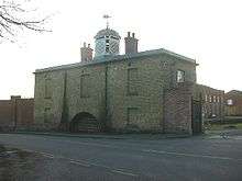
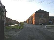
Next to the canal is the former Napoleonic War era Military Ordnance Depot (established by Act of Parliament in 1803).[4] The depot, which was the central small arms depot for the British Army, was originally served by the canal, by its own branch which entered through a portcullis. (When the railway was built, it also had a branch into the depot.) Designed by Colonel Pilkington of the Royal Engineers, the depot was largely built between 1805 & 1806.
The depot consisted of eight large storehouses, built either side of the central canal and surrounded by a high stone wall. The upper floors were used for storage of small arms and the like, the ground floors for larger items (field artillery, etc.) There were canal gatehouses at each end of the precinct; beyond, at a safe distance, the canal entered a further walled area, likewise gated at either end, which contained a row of four gunpowder magazines (each separated from the next by a 'blast house' filled with earth as a precaution against explosions). Later, another magazine was added, as well as a large 'clothing store', between the two precincts, in 1902. All the aforementioned buildings survive (among others) to this day, and they (together with the enclosure walls) are listed Grade II*.[5]
There was also a barracks in the village, holding a standing battalion, plus a troop of cavalry and a troop of horse artillery. The barracks were demolished in the 1950s. Three large pavilions were built between the depot and barracks to house the senior civilian officers of the depot. These were demolished in the 1960s. Next door to the barracks was the Army School of Equitation, also demolished in the 1960s. The depot became redundant in 1965 and was sold by the Ministry of Defence in 1984. It is now used for storage and light industry.
Fire Services National Museum
The Fire Services National Museum has been working for many years to secure planning approval for the museum to be an integral part of the former ordnance depot but progress has been hampered by planning and ownership issues, and progress is on hold.[6]
Notable residents
- Leo G. Carroll (1886–1972), actor (The Paradine Case, North by Northwest and others), was born in Weedon Bec.
- Patrick Leigh Fermor (1915–2011), writer, spent his first four years in Road Weedon.[7]
- Tom MacRae (1980–present), writer, "Rise of the Cybermen", "The Age of Steel" and several other Doctor Who episodes. McRae also wrote the series Threesome. Born and raised in Weedon Bec.
See also
- Northamptonshire Villages, (2002) Countryside Books, ISBN 1-85306-764-4
References
- ↑ "Civil Parish population 2011". Neighbourhood Statistics. Office for National Statistics. Retrieved 11 July 2016.
- ↑ "UK census 2001 - data". Retrieved 28 December 2008.
- ↑ "Blisworth website 1920's map shows the various parts of Weedon around the crossroads". Retrieved 2008-12-28.
- ↑ Old photographs of the barracks including 1920s map showing railway and canal connections as well as location of Weedon station
- ↑ English Heritage Survey, pp 70-75
- ↑ Fire Services National Museum Trust
- ↑ Obituary in The Independent
External links
| Wikimedia Commons has media related to Weedon Bec. |
- Parish council
- Weedon Surgery
- History of the village
- The birth of radar in February 1935
- English Heritage - Thematic Survey of the Ordnance Yards and Magazine Depots