West Blatchington
Coordinates: 50°50′46″N 0°10′48″W / 50.846°N 0.180°W
| West Blatchington | |
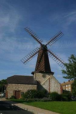 The windmill |
|
| Unitary authority | Brighton and Hove |
|---|---|
| Ceremonial county | East Sussex |
| Region | South East |
| Country | England |
| Sovereign state | United Kingdom |
| Post town | BRIGHTON |
| Postcode district | BN3 |
| Dialling code | 01273 |
| Police | Sussex |
| Fire | East Sussex |
| Ambulance | South East Coast |
| EU Parliament | South East England |
| UK Parliament | Hove |
|
|
West Blatchington is an area in Hove, East Sussex, England.
The area grew rapidly in the inter-war period, but unlike nearby Hangleton it had more infrastructure, with St Peter's Church, a working farm, a windmill and an industrial area grouped around the Goldstone Pumping Station and its workers' cottages.[1]
Blatchington Mill School, formed in 1979 from the Hove County Grammar School, Knoll Boys School and Nevill Secondary School, lies in the centre of West Blatchington.
The area is crossed by the Monarch's Way long-distance footpath, heading towards its terminus at Shoreham-by-Sea.
References
| Wikimedia Commons has media related to West Blatchington. |
- ↑ "Welcome to West Blatchington". My Brighton and Hove website. My Brighton and Hove (c/o QueensPark Books). 22 March 2006. Retrieved 27 September 2008.
This article is issued from Wikipedia - version of the 8/18/2016. The text is available under the Creative Commons Attribution/Share Alike but additional terms may apply for the media files.