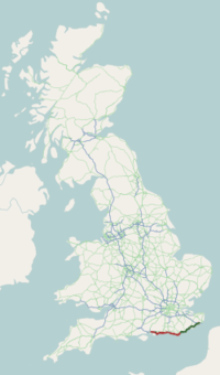
A259 road
| |
|---|---|
 | |
| Route information | |
| Length: | 118.5 mi[1] (190.7 km) |
| Major junctions | |
| East end: | Folkestone |
|
[[Image:Motorway Left.svg|[ |x30px|link=]] | |
| West end: | Emsworth |
| Location | |
| Primary destinations: |
Bexhill-on-Sea Brighton Bognor Regis Chichester Eastbourne Folkestone Hastings Littlehampton Worthing Rye Shoreham-by-Sea |
| Road network | |

The A259 is a road on the south coast of England passing through Hampshire, West Sussex, East Sussex and part of Kent. Part of the road was named "the most dangerous road in South East England" in 2008,[2] and the BBC named the road as the 'most crash prone A road' in the UK with 7,721 crashes and 120 deaths over 12 years from 1999–2010, an average of 65 crashes per mile.[1]
Description

The A259 is a busy two-lane road running along the south coast of England; part is almost parallel to the A27 road. The A259 runs east from Emsworth in Hampshire, into West Sussex via Chichester, Bognor Regis, Littlehampton, Ferring, Worthing, Lancing, Shoreham-by-Sea, into the Unitary Authority of Brighton and Hove which incorporates Portslade, Hove and Brighton, and on into the East Sussex towns of Peacehaven, Newhaven, Seaford, Eastbourne, Pevensey, Bexhill-on-Sea, Hastings and Rye. Over the border in Kent, it continues through New Romney and Hythe to terminate at Folkestone.
The road passes through the town of Winchelsea, England's first new town. The road has Trunk Road status between Pevensey and Brenzett (A2070) and formed part of the formerly designated South Coast Trunk Road.[3] This section of A259 is almost entirely single-carriageway, with only a short stretch of urban dual carriageway in Bexhill.
Road safety
In June 2008, a 12 miles (19 km) stretch of the A259 between Hastings and Eastbourne was named as the most dangerous road in the South East of England.
Landmarks
- Butlins South Coast World in Bognor Regis
- Shoreham Power Station
- West Pier in Brighton
- Telscombe Cliffs near Peacehaven and Saltdean
- Cuckmere Haven between Seaford and Eastbourne
- Romney, Hythe and Dymchurch Railway, which shares the route for 8 miles (13 km) from New Romney to Hythe
History
In 1989 the government of the day proposed to dual the road from Pevensey to Bexhill and make other corridor improvements as detailed in their Roads for Prosperity white paper and would have included the following elements: 'Guestling and Icklesham bypass', the 'Winchelsea bypass', 'Rye bypass', 'Ham Street bypass', 'A259 New Romney bypass' and the 'A259 St. Mary's Bay and Dymchurch bypass'.[4] This scheme along with many others proposed at the time were shelved in 1996-7 after a number of major road protests in the UK.
Plans for a 'Hastings Bexhill bypass' which would have provided a dual-carriageway from the Pevensey roundabout passing to the north of Bexhill and Hastings to join the current A259 near Icklesham at a cost of £120-£130 million were rejected in 2001. The scheme, which was supported by the South East England Regional Assembly and by the Deputy Prime Minister, John Prescott was opposed by English Nature who highlighted the damage to a number of Sites of Special Scientific Interest (SSSIs), including the High Weald Area of Outstanding Natural Beauty. They were also concerned about the negative effect the scheme would have on several ancient woodlands and the habitats of the dormouse and great crested newt.[5][6]
The section between Brenzett and Folkestone was de-trunked in 2003 (i.e. removed trunk road status) and control reverted to Kent County Council.[7]
Other development proposals for the road were considered in 2004.[8]
It was named as one of the most dangerous road in South East England in 2008.[9]
Proposed developments
Bexhill to Hastings link road
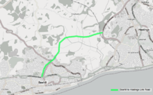
East Sussex County Council proposed building a new link road between Bexhill and Hastings, to form a 3.5 miles (5.6 km) long road from its junction with the A259 in Bexhill to a junction with the B2092 Queensway in Hastings.[10]
The South East Regional Assembly included the scheme within its Regional Funding Advice package.[11] This was provisionally signed off in July 2009 by the Department for Transport, with the caveat that individual schemes would still need to be assessed for value for money and compatibility with greenhouse gas emission targets.[12] Although originally estimated at £45 million, the scheme was now expected to cost over £100 million. £33 million was expected to come from developer contributions, but the County Council was unable to obtain them. "Although opportunities will be explored to seek developer contributions in the future, at the present it has been considered prudent to plan to fund all future local contributions from the County Council’s capital programme".[13]
The County Council said that "The driving force of the scheme is to enable essential economic regeneration for Bexhill and Hastings, which is currently compromised by the poor accessibility within and between the two towns... the Bexhill Hastings Link Road would make a major contribution to meeting the need to improve access between the towns and linking Trunk Roads which serve the area". They also identified that the scheme would provide "faster and more reliable access to the Conquest Hospital", "easier access to jobs", "create access to much-needed additional housing"; and that it would "re-route traffic from less suitable roads" and "reduce the number of accidents on local roads".[14]
A number of organisations objected to the scheme. The Hastings Alliance,[15] which is supported by 11 national bodies including the Campaign for the Protection of Rural England, the Council for National Parks and WWF-UK and also 16 local groups[16] pointed to the Hastings Five Point Plan, commissioned by the South East Regional Assembly, which found that the key requirement for regeneration is to "improve the strategic accessibility of Hastings – that is Hastings’ access to London, other major towns, and other parts of the South East" and says that improving rail links are fundamental to regenerating that area.[17] In addition they objected to the impact on the Combe Haven valley, a Site of Special Scientific Interest, which would be cut in two by the scheme. The Campaign for Better Transport say that, contrary to Government guidance, the County Council had "never really considered whether building a link road is the best way to improve transport on the Sussex coast".[18] The Woodland Trust also objected as the road would seriously impact on the Marline Valley Woods Site of Special Scientific Interest, an ancient ghyll woodland. This sort of woodland is only found on steep sided valleys and are hugely important for wildlife but are highly sensitive to pollution. The road would also pass within metres of Church wood (ancient woodland) and other nationally and locally protected wildlife sites.[19] Friends of the Earth were concerned that building roads generates more traffic in the surrounding area and in particular would result in more vehicles using the roads to the north creating pressure in for communities on the approach roads[20] (such as the A21 and the A28). They also believed is would create pressure to build a 'Hastings Eastern Bypass' which would pass through the High Weald Area of Outstanding Natural Beauty which they claim is one of Britain’s finest landscapes. The Sussex Wildlife Trust "strongly" objected to the road stating that "the environmental damage that will result from this scheme is unacceptable and will alter the ecology of the Combe Haven valley for ever."[21]
A public inquiry into the scheme started on 10 November 2009.[22]
When the Bexhill to Hastings Link Road was eventually approved then changes also needed to be made to the A21 Baldslow / Queensway (which leads to the link road).
The work was completed late in 2015 at a cost of between £90 and £100 million.[23]
'£5m improvements near Shoreham'
Brighton and Hove City Council, Adur District Council and West Sussex County Council and the Shoreham Port Authority are proposing to spend a £5million grant from the DfT to 'improve the A259 in relation to a new project to build 10,000 homes scheme.[24]
References
- 1 2 "Every death on every road". BBC News. 2 December 2011.
- ↑ "Great Britain Results 2008". EuroRAP. Archived from the original on 10 February 2012.
- ↑ "Highways Agency Network Map". Highways Agency. November 2011. Retrieved 18 December 2012.
- ↑ "House of Commons Hansard Debates". 13 July 1989.
- ↑ "Hastings/Bexhill bypass 'flawed'". BBC news. London. 15 February 2001. Retrieved 2010-03-24.
- ↑ "Ruling Splits Opinion". BBC news. London. 12 July 2001. Retrieved 2010-03-24.
- ↑ "The A259 Trunk Road, (Brenzett to M20 Junction 13, Folkestone) (Detrunking) Order 2003". UK Government. Retrieved 6 June 2012.
- ↑ "Highways Agency A259-A2070 Route Management Strategy" (PDF). East Sussex Council.
- ↑ "Britain's most dangerous roads revealed". Autotrader.
- ↑ "Bexhill to Hastings link road". East Sussex County Council. Retrieved 2008-01-21.
- ↑ "South East England Regional Funding Advice" (PDF). South East Regional Assembly. Retrieved 2009-11-10.
- ↑ "Response letter to South East England Regional Funding Advice" (PDF). Department for Transport. Retrieved 2009-11-10.
- ↑ "Hastings Bexhill Major Scheme Business Case" (PDF). East Sussex County Council. Retrieved 2009-11-10.
- ↑ "Design and Access statement (section 2.1.1 - 174mb)" (PDF). East Sussex County Council. Retrieved 2009-11-10.
- ↑ "Hastings Alliance". Hastings Alliance.
- ↑ "Supporters". Hastings Alliance.
- ↑ "Prosperity for Hastings" (PDF). South East Regional Assembly.
- ↑ "Reject Bexhill-Hastings link road". Campaign for Better Transport.
- ↑ "Bexhill to Hastings Link Road". Woodland Trust.
- ↑ "Like a bad penny. why Friends of the Earth opposes the Bexhill" (PDF). Friends of the Earth. Retrieved 2009-11-09.
- ↑ "Bexhill Hastings Link Road". Sussex Wildlife Trust. Retrieved 2013-08-19.
- ↑ "Bexhill-Hastings link road cash sign-off slated by campaigners". planningresource.co.uk.
- ↑ "A21 Baldslow Junction Improvements" (PDF). South East England Regional Assembly.
- ↑ "Councils vow to revive Shoreham Harbour plans".
External links
- A259 Folkestone-Havant — From SABRE's "Roads By 10".
- Hastings Alliance Opposition to the Bexhill to Hastings Link Road
- Road Safety Foundation
A roads in Zone 2 of the Great Britain road numbering scheme | ||
|---|---|---|