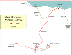
West Somerset Mineral Railway
 | |
|
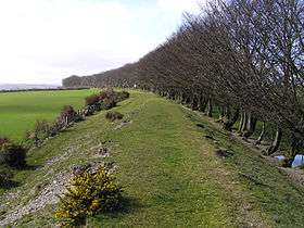
A view along the embankment from SS986354 looking westwards towards Gupworthy from the Withiel road underbridge | |
| Locale | Somerset |
|---|---|
| Dates of operation | 1856–1917 |
| Track gauge | 4 ft 8 1⁄2 in (1,435 mm) standard gauge |
| Website | West Somerset Mineral Railway |
The West Somerset Mineral Railway was a standard gauge line in Somerset, England. The line carried iron ore from mines in the Brendon Hills to the port of Watchet on the Bristol Channel. From there the ore was shipped northwards to Newport where it was unloaded onto railway wagons and hauled to ironworks at Ebbw Vale.
The line included a massive rope-worked inclined plane 3,272 feet (997 m) long to bring the ore down a 770 feet (230 m) vertical interval on a 1 in 4 gradient.
The line opened fully in 1861, and for a period passengers were carried, but mineral extraction declined and the railway, declining with it, closed in 1898. A new mineral venture was attempted in 1907, and the line was partly re-opened, but this also failed and the line closed again in 1910, being lifted during the First World War
Origins
West Somerset Mineral Railway (WSMR) | |||||||||||||||||||||||||||||||||||||||||||||||||||||||||||||||||||||||||||||||||||||||||||||||||||||||||||||||||||||||||||||||||||||||||||||||||||||||||||||||||||||||||||||||||||||||||||||||||||||||||||||||||||||||||||||||||||||||||
|---|---|---|---|---|---|---|---|---|---|---|---|---|---|---|---|---|---|---|---|---|---|---|---|---|---|---|---|---|---|---|---|---|---|---|---|---|---|---|---|---|---|---|---|---|---|---|---|---|---|---|---|---|---|---|---|---|---|---|---|---|---|---|---|---|---|---|---|---|---|---|---|---|---|---|---|---|---|---|---|---|---|---|---|---|---|---|---|---|---|---|---|---|---|---|---|---|---|---|---|---|---|---|---|---|---|---|---|---|---|---|---|---|---|---|---|---|---|---|---|---|---|---|---|---|---|---|---|---|---|---|---|---|---|---|---|---|---|---|---|---|---|---|---|---|---|---|---|---|---|---|---|---|---|---|---|---|---|---|---|---|---|---|---|---|---|---|---|---|---|---|---|---|---|---|---|---|---|---|---|---|---|---|---|---|---|---|---|---|---|---|---|---|---|---|---|---|---|---|---|---|---|---|---|---|---|---|---|---|---|---|---|---|---|---|---|---|---|---|---|---|---|---|---|---|---|---|---|---|---|---|---|---|---|
Legend | |||||||||||||||||||||||||||||||||||||||||||||||||||||||||||||||||||||||||||||||||||||||||||||||||||||||||||||||||||||||||||||||||||||||||||||||||||||||||||||||||||||||||||||||||||||||||||||||||||||||||||||||||||||||||||||||||||||||||
| |||||||||||||||||||||||||||||||||||||||||||||||||||||||||||||||||||||||||||||||||||||||||||||||||||||||||||||||||||||||||||||||||||||||||||||||||||||||||||||||||||||||||||||||||||||||||||||||||||||||||||||||||||||||||||||||||||||||||
In the mid-nineteenth century, the proprietors of the Ebbw Vale Iron Works acquired an interest in iron ore deposits in the Brendon Hills on the north side of Exmoor. Iron ore had been known there for centuries but not exploited industrially until the Brendon Hills Iron Ore Company was formed, in 1853.[1] At an altitude of over 1,000 feet (300 m) and remote from usable roads, the deposits needed a form of transport to get the ore to South Wales. Thomas Brown (1803-1884), managing partner of the Ebbw Vale company realised that a railway to the quay at Watchet was the solution. The line was designed by Rice Hopkins.[2]
The Ebbw Vale proprietors formed the West Somerset Mineral Railway for the purpose, and obtained Parliamentary authority on 16 July 1855 for a standard gauge 1,435 mm (4 ft 8 1⁄2 in) line from Watchet Quay to Heath Poult (or "Exton").[3] The authorised capital was £50,000.[note 1][4] Work started on construction in May 1856, and a locomotive was obtained in November 1856; however it was put out of action in January 1857 by serious damage to the boiler.[3]
The line was ready for traffic from Watchet to Roadwater by April 1857,[5] and for the time being that acted as the railhead for the minerals; the line was extended to Comberow (7.5 miles (12.1 km) from the harbour) by 1857.[6] In the interim, however, another accident occurred when two locomotives collided, killing three men.[3] An Act was obtained on 27 July 1857 to extend the line to Minehead, with a branch to Cleeve; an additional £35,000 capital was authorised, but this work was never carried out.[4]
The incline, and early operations
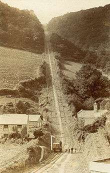
The formidable rise in altitude to reach the mines was accomplished by a gravity worked incline, 0.75 miles (1.21 km) long, on a gradient of 1 in 4. To achieve the constant gradient, formidable earthworks were necessary, and construction took four years with a Mr Gunn as the contractor.[2][7] While this was going on mining had been proceeding apace and large stocks of ore were waiting at the incline head to be conveyed to the harbour. Ore was brought down the incline while it was being completed, from 31 May 1858, and it was not fully finished until March 1861,[8] when two 18 feet (5.5 m) diameter winding drums were installed on a single axle, located below the track, at Brendon Hill.[2] Public goods traffic was accepted from 28 September 1859.[9]
A single wagon containing five tons of ore could be lowered down the plane in twelve minutes. Railway-type signals were used to indicate that an ascending wagon had been attached to the rope; the brakesman at the upper level then levered the descending, loaded wagon to the brow of the hill, and the descent and ascent began. The descent was controlled by braking.[2] The WSMR line was leased to the Brendon Hills Iron Ore Company for seven years from 1859, and the latter was to work the line. The lease was extended and transferred to the Ebbw Vale Iron Company on 24 June 1864.[10][4] In the same year an advertisement was placed in the Somerset County Gazette announcing that "coal, culm, lime corn, flour, manure, building materials and other goods" would be carried on the railway at reduced rates.[11]
Watchet Harbour

Although the outward terminal of the line was to be the quay at Watchet, the pier had been practically unusable for some considerable time, and boats were beached and loaded direct from carts brought on to the foreshore.[12] After considerable public pressure, the Watchet Harbour Act was passed in 1857, placing it under the control of Commissioners; they built a new east pier and rebuilt the west pier; the work was finished in 1862, and 500 ton vessels could enter the harbour.[9] The WSMR used the west pier, and the newly arrived, broad gauge West Somerset Railway, a branch from the Bristol and Exeter Railway, used the east pier.[13][14]
The West Somerset Railway opened as far as Watchet on 3 March 1862. Although a connection with the WSMR was suggested, involving laying of mixed gauge on the Mineral line, this never happened.[10]
Extension beyond the head of the incline
Construction as far as Raleigh's Cross,[note 2] at the head of the incline, had cost £82,000 compared with the estimate of £65,000 for construction of the entire line. Further construction was delayed, therefore, but it resumed in 1863 and reached Gupworthy in September 1864. The goal of reaching Hoult Point, the originally intended western terminal of the line, was abandoned. By now the Ebbw Vale Company Ltd had taken over the Iron Works company, and also the mines, and a new lease of the line was made to to them lasting until September 1919.[10]
Passenger operation
At the top of the incline the line ran along the Brendon ridge in both directions, eastward to Raleigh's Cross and the Colton mines and westward to a heathland terminus named after the nearby village of Gupworthy. Considerable numbers of miners lived in these remote areas. For some time the Company had permitted them and their families to travel on the line free of charge and at their own risk.
It was decided to operate a formal passenger service between Comberow and Watchet, and this started on 4 September 1865.[9] In the full year 1866 13,000 passengers were carried; by 1872 this had risen to 19,000. Four passenger trains ran each way daily at first, but this was later reduced to two, and then to one. Proper stations were provided at Watchet, Washford, Roadwater and Comberow.[15] Brendon Hill, at the top of the incline, sometimes referred to as Raleigh's Cross, was also considered to be a station,[16] but seems not to have formal station facilities.
Passengers were conveyed on trucks up the incline free and at their own risk: Sellick shows a photograph of a flat wagon on the incline, with six passengers seated on makeshift boxes[17] and a further photo at Gupworthy with three passengers on a wagon.[18] Mitchell and Smith point out that the Ordnance Survey map shows "Station" at Gupworthy: the Company's building there evidently seemed to be a station to the surveyors.[5][19] There was also a station at Luxborough Road
The line operated successfully and settlements of people attracted to the area by the prospect of employment in the mines grew around the Brendon ridge. However changes in the availability of imported ore made the mines a less attractive proposition and by 1880 the mines were closed and mineral traffic on the railway ceased. In 1879 the railway announced that the wages of all staff would be reduced.[20] The passenger service continued until 7 November 1898; a brief resumption took place from 1907 (but not west of Brendon Hill) until final closure to passengers in 1910.[15][10] The 1895 Bradshaw shows two return trips every day, at 09:15 and 15:10 from Watchet, calling at Washford, Roadwater and Comberow, taking 30 minutes; return trains were at 10:45 and 16:15, also taking 30 minutes.[21]
Decline and closure
.jpg)
The profitability of the mineral extraction operation was never as large as was hoped, and there was a decline in the industry from 1883.[5] The railway continued in operation, although it had lost its primary traffic. A second-hand Robey steam engine was installed at the head of the incline to power the drums, hauling wagons up in the absence of a regular downhill flow.[15] For many years the line also was operating at a loss, and on 7 November 1898 traffic was suspended by agreement with the Ebbw Vale Company, who paid £5,000 per annum in compensation.[4][5]
In 1907 another venture, the Somerset Mineral Syndicate, leased the railway and resumed mining, re-opening the railway on 4 July 1907 with a one-off special train and the town band.[22][23] The lower section of the line and the incline were brought back into use, but the Gupworthy extension from Brendon Hill remained closed. The incline reverted to gravity operation.[2] £1,500 was expended on a new jetty at Watchet, a kiln costing £2,000 was built at Washford.[24] and a new 2 feet (0.61 m) gauge tramway was built from Brendon Hill to the Colton Iron Mine. Colton was at a much lower altitude than Brendon Hill, so the tramway had to ascend from the mine on a new double track incline worked by a stationary steam engine using a two-cylinder winch drive with twin drums.[25] The tramway then ran nearly 2 miles (3.2 km) to Brendon Hill, where the ore was tipped into standard gauge wagons, lowered down the incline and hauled to Watchet.[26]
The venture was unsuccessful—the ore tended to cake in the furnace—and the mines closed in March 1910. The jetty was sold for £70 and the kiln for £5.[2][27][9]
In 1911 an Australian inventor A.R. Angus used the lower section of the line to test and demonstrate an automatic signal warning device, but that was the last time the line was used.[28] The demonstration of the system took place at Kentsford on 5 July 1912, and turned into something of a gala for local people, watching two hired GWR tender locos, the only tender locos to work this line, being brought safely to a halt rather than the anticipated head-on collision.[29][30] Testing of this system continued intermittently until the outbreak of war.
The War Department requisitioned the rails during the First World War and they were lifted for scrap in 1917.[27] A majority of the railway company board proposed seeking an abandonment order at once, but a rival Board was established; they continued to receive the Ebbw Vale Company’s contracted lease payments until the lease expired in 1919.[31][9] In 1923 an Act of Parliament was passed authorising abandonment of the railway activity.[4][32]
Locomotives
Main line
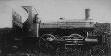
Two different types of locomotives were used during the first period of operation of the line. The smaller locomotives were 0-4-0ST tanks built by Neilson and Company. The earliest ones were so-called "box tanks"—they had a water tank over the boiler with a rectangular profile—and two were delivered ready for the line's opening. However one was later replaced following the fatal collision at Kentsford in August 1857.[33][3][34] One was returned to Ebbw Vale in 1883 but the fleet was increased to two again in December 1896. They usually operated above the incline: below that point larger Sharp, Stewart 0-6-0STs were used.[35] The first arrived in 1857 and a second in 1866. The two locomotives spent short spells at Watchet in the 1890s.[34]
When the line reopened in 1907 just one locomotive was used. This was a Beyer Peacock 4-4-0T built in 1879 for the Metropolitan Railway in London, it was number 37 of their A Class condensing locomotives. It arrived on the railway on 30 June 1907 by way of a temporary connection from the Great Western Railway (GWR) at Kentsford.[36]
Two tender locomotives were used to demonstrate the Angus automatic train control equipment; they had originally been West Midland Railway 2-4-0s numbers 103 and 104. They were on the WSMR from 17 December 1911 and used for a demonstration on 5 July 1912. On 4 November 1917 they were moved to Taunton, where they were stored until 1919. After being sold to the Bute Works Supply Company in 1920 they were sold on to the Cambrian Railways in 1921[34][37] as their numbers 10 and 1. They were absorbed into the Great Western Railway as 1328 and 1329.
| Name/number | Builder | Works no. | Built | Wheels | In use[34] |
|---|---|---|---|---|---|
| – | Neilson and Co. | 370 | 1856 | 0-4-0ST | 1856–c.1897 |
| – | Neilson and Co. | ? | ? | 0-4-0ST | 1857 |
| Rowcliffe | Sharp, Stewart | 995 | 1857 | 0-6-0ST | 1857–c.1883 |
| – | Neilson and Co. | ? | c.1861 | 0-4-0ST | c.1865–1883 |
| Pontypool | Sharp, Stewart | 1677 | 1866 | 0-6-0ST | 1866–1899 |
| Esperanza | Sharp, Stewart | 2262 | 1872 | 0-6-0ST | c.1894 |
| Whitfield | Sharp, Stewart | 1011 | c.1857 | 0-6-0ST | 1895 |
| Newport[38] | Neilson and Co. | ? | 1855 | 0-4-0ST | 1896–c.1900 |
| 37 | Beyer Peacock | 1881 | 1879 | 4-4-0T | 1907–1910 |
| 212 | Beyer Peacock | 248 | 1861 | 2-4-0 | 1911–1917 |
| 213 | Beyer Peacock | 249 | 1861 | 2-4-0 | 1911–1917 |
As the railway was effectively split into two halves by the incline, two engine sheds were needed, one for the lower level line from Watchet to Comberow and another for the upper level south of the incline top.
The stone built lower level shed was known as "Watchet". It had one "road" (track)[39] and stood east of the line a short distance south of Watchet (WSMR) station.[40] It was open for two periods: April 1857 to 7 November 1898 and 4 July 1907 to 1910. In 2015 it was in use as a dwelling.
The upper level had two sheds which covered different periods, they were both known as "Brendon Hill". The first had one "road" (track) and was located within the Raleigh's Cross Mine site.[41] It opened with the public goods service on 28 September 1858 and closed before 1880. It was subsequently used as a carpenter's workshop until the mine closed in the 1890s. The second shed also had a single "road", it was located south of the line south of the site of Carnarvon Pit.[42] It was open for two periods: from an unknown date to 7 November 1898 and from 4 July 1907 to 1910.[43] Both Brendon Hill sheds have long been demolished.
Colton Tramway
The 2 ft (610 mm) Colton Tramway was worked by two small locomotives, both of which faced Brendon Hill.
| Name/number | Builder | Works no. | Built | Wheels | In use[34] |
|---|---|---|---|---|---|
| – | W.G. Bagnall | 300 | 1880 ? | 0-4-0T | c.1907–1910 |
| – | Kerr Stuart | 702 | 1900 ? | 0-4-0IST | c.1907–1910 |
Remains of the line

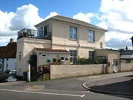
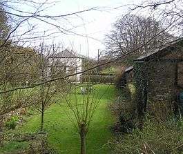
Today the line can still be seen in places, although much of it is private property. The former station at Watchet is in use today (2002) as flats, "Old Station House", and the nearby goods shed survives also.[15]
The line runs parallel to the West Somerset Railway from Watchet to Washford[44] where it forms a foot and cycle path. Washford station has been demolished and a bungalow is on the site.[15] The line then curves south west, partly in the form of a road, past Cleeve Abbey and Roadwater, where the station buildings survive (2002) with an extension to form a bungalow.[15] The line continues to Comberow. The siding group that was at the foot of the incline is clearly identifiable here at Comberow, to the west of the bridge that carried the incline, as does the station master's house and traces of the platform (2002).[15] Part of the line northwards from there seems to be a footpath.
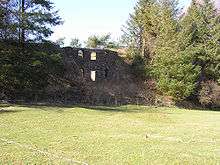
The incline from there is not visible because of tree growth and it is difficult to get access to it without unreasonable encroachment on private property, although the OS map shows a public footpath crossing the incline about two-thirds of the way up. The remains of the Brendon Hill station are a Grade II listed building.[45] The remains of the summit winding house can be approached but are dangerous to enter: they are located just west of the junction of the B3224 and B3190 roads. A chapel built to attend to the spiritual needs of the miners and their families still stands at the junction.
The line is located in the Exmoor National Park, and funds have been made available for conservation through the Heritage Lottery Fund and other sources.[46] Work has been undertaken on the incline winding house and trees cleared from the incline and repair and preserve the remaining industrial structures.[47][48]
The line continued west to Gupworthy with modest earthworks, and bridge abutments can be seen where minor roads cross the alignment. There is a private house at the former Gupworthy station (at SS963356); this was the railway house and the alignment is visible there. The Grade II listed incline site is owned by Exmoor National Park.[2]
The Carnarvon New Pit iron mine and a section of the mineral railway track-bed adjacent to it has been designated as an ancient monument.[49][50] It has been added to the Heritage at Risk register because of vulnerability from scrub and tree growth.[51]
Notes
- ↑ Thomas says £65,000; he may be taking the £50,000 share capital with authorised debenture borrowings.
- ↑ This was on Brendon Hill. At this time there was no more specific location than Raleigh's Cross, which was a mile or so to the east; the location on the railway was later referred to as "Brendon Hill"
References
- ↑ "Brendon Hills Iron Mining and the Exmoor National Park". Everything Exmoor. Retrieved 19 July 2014.
- 1 2 3 4 5 6 7 Bodman 2012.
- 1 2 3 4 Sellick 1981, p. 5.
- 1 2 3 4 5 Carter 1959.
- 1 2 3 4 Mitchell & Smith 1990.
- ↑ "Combe Row Station". Pastscape. English Heritage. Retrieved 19 July 2014.
- ↑ "West Somerset Mineral Railway Extension". North Devon Journal. British Newspaper Archive. 29 September 1864. Retrieved 19 July 2014. (subscription required (help)).
- ↑ R.W. Dunning (editor), A.P. Baggs, R.J.E. Bush, M.C. Siraut (1985). "Parishes: Old Cleeve". A History of the County of Somerset: Volume 5. Institute of Historical Research. Retrieved 22 July 2014.
- 1 2 3 4 5 Thomas 1966.
- 1 2 3 4 Sellick 1981, p. 6.
- ↑ "West Somerset Mineral Railway". Somerset County Gazette. British Newspaper Archive. 5 March 1864. Retrieved 19 July 2014. (subscription required (help)).
- ↑ Farr 1954, pp. 125-137.
- ↑ "Watchet harbour". Ports.org.uk. Retrieved 19 July 2014.
- ↑ Sellick 1981, p. 15.
- 1 2 3 4 5 6 7 Oakley 2002.
- ↑ Butt 1995.
- ↑ Sellick 1981, p. 24.
- ↑ Sellick 1981, p. 26.
- ↑ "Ordnance Survey 1:10560 County Series 1st edition (c.1884-87) Sheet 58 Subsheet 01". Somerset County Council. Retrieved 19 July 2014.
- ↑ "Reduction in Wages". Western Daily Press. British Newspaper Archive. 5 February 1879. Retrieved 19 July 2014. (subscription required (help)).
- ↑ Bradshaw 2011.
- ↑ Sellick 1981, p. 40.
- ↑ Dale 2001, Front cover.
- ↑ "Teacher's Pack Overview". West Somerset Mineral Railway. Retrieved 8 October 2014.
- ↑ Sellick 1981, pp. 48-9.
- ↑ "MSO7702 - Colton Pits". Exmoor National Park. Retrieved 8 October 2014.
- 1 2 Sellick 1981, p. 7.
- ↑ Leleux, Sydney A. "West Somerset Mineral Railway". The Industrial Railway Record. Industrial Railway Society. Retrieved 19 July 2014.
- ↑ Madge (1975), pp. 63–64.
- ↑ Dale 2001, p. 36.
- ↑ "West Somerset Mineral Railway Action". Western Daily Press. British Newspaper Archive. 23 May 1919. Retrieved 19 July 2014. (subscription required (help)).
- ↑ "West Somerset Mineral Railway". Western Daily Press. British Newspaper Archive. 19 April 1923. Retrieved 19 July 2014. (subscription required (help)).
- ↑ "Dreadful Collision on the West Somerset Mineral Railway". Taunton Courier, and Western Advertiser. British Newspaper Archive. 26 August 1857. Retrieved 19 July 2014. (subscription required (help)).
- 1 2 3 4 5 Hately 1977, p. 73.
- ↑ Sellick 1981, pp. 26-7.
- ↑ Sellick 1981, pp. 38-40.
- ↑ Sellick 1981, p. 50.
- ↑ "Newport, temporary replacement locomotive in Somerset in 1896". West Somerset Mineral Railway Project. Retrieved 18 April 2011.
- ↑ Sellick 1981, p. 29.
- ↑ Watchet WSMR locoshed at: 51°10′51″N 3°20′04″W / 51.1808°N 3.3345°W
- ↑ Brendon Hill's first locoshed at: 51°05′56″N 3°23′33″W / 51.0990°N 3.3926°W
- ↑ Brendon Hill's second locoshed at: 51°05′55″N 3°23′59″W / 51.0987°N 3.3996°W
- ↑ Griffiths & Smith 1999, pp. 22-24.
- ↑ "The Old Mineral Line". OS Explorer. Retrieved 19 November 2007.
- ↑ Historic England. "Former Brendon Hill Mineral Railway Station (1057540)". National Heritage List for England. Retrieved 5 April 2015.
- ↑ "The West Somerset Mineral Railway Project". Exmoor National Park. Retrieved 19 July 2014.
- ↑ "West Somerset mineral line railway". funicular railways of the UK. Retrieved 19 November 2007.
- ↑ "West Somerset Mineral Railway". The Historical Association. Retrieved 19 July 2014.
- ↑ "West Somerset Mineral Railway". Exmoor National Park. Retrieved 19 July 2014.
- ↑ "Carnarvon New Pit iron mine and section of mineral railway trackbed, 300 m south west of Heather House". National Heritage list for England. English Heritage. Retrieved 20 October 2013.
- ↑ "Carnarvon New Pit iron mine and section of mineral railway trackbed, 300 metres south west of Heather House, Brompton Regis, West Somerset — Exmoor (NP)". Heritage at Risk. English Heritage. Retrieved 20 October 2013.
Bibliography
- Bodman, Martin (2012). Inclined Planes in the South West. Twelveheads Press. ISBN 978-0906294758.
- Bradshaw (2011) [1st. Pub. December 1895]. Bradshaw's Rail Times 1895: A Reprint of the Classic Timetable. Middleton Press. ISBN 978-1908174116.
- Butt, R. V. J. (1995). The Directory of Railway Stations: details every public and private passenger station, halt, platform and stopping place, past and present (1st ed.). Sparkford: Patrick Stephens Ltd. ISBN 1-8526-0508-1. OCLC 60251199.
- Carter, E. (1959). An Historical Geography of the Railways of the British Isles. Cassell.
- Dale, Peter (2001). Somerset's Lost Railways. Stenlake Publishing. ISBN 978-1-84033-171-4.
- Griffiths, Roger; Smith, Paul (1999). The Directory of British Engine Sheds and Principal Locomotive Servicing Points: 1 Southern England, the Midlands, East Anglia and Wales. OPC Railprint. ISBN 0-86093-542-6. OCLC 59458015.
- Farr, Grahame (1954). Somerset Harbours. Christopher Johnson.
- Hately, Roger (1977). Industrial locomotives of South Western England. Industrial Railway Society Publications. ISBN 978-0901096234.
- Jones, M.H. (2011). The Brendon Hiills Iron Mines and the West Somerset Mineral Railway. Lightmoor Press. ISBN 9781899889-5-3-2.
- Madge, Robin (1975) [1971]. "7: Watchet–Brendon Hill". Railways Round Exmoor. Exmoor Press. pp. 60–65. ISBN 0-900131-18-7.
- Mitchell, Vic; Smith, Keith (1990). Branch Line to Minehead: Preservation Perfection. Middleton Press. ISBN 978-0906520802.
- Oakley, Mike (2002). Somerset Railway Stations. Dovecote Press. ISBN 978-1904349099.
- Sellick, R.J. (1981) [1976]. The Old Mineral Line. Wellington: Halsgrove. ISBN 978-1-84114-692-8.
- Thomas, David St John (1966). Regional History of the Railways of Great Britain: The West Country v. 1. David & Charles. ISBN 0946537178.
Further reading
- Gathercole, Clare (2003) Watchet Archaeological Assessment (Somerset County council)
- Lelux, S.A. (1969) West Somerset Mineral Railway, Industrial Railway Record
- Scott-Morgan, John (1980). British Independent Light Railways. Newton Abbot: David and Charles. ISBN 0 7153 7933 X.
- Ordnance Survey Map: Explorer OL9 Exmoor (The top of the incline is at Grid Reference ST023344)
External links
| Wikimedia Commons has media related to West Somerset Mineral Railway. |
- A walk on the West Somerset Mineral Railway (Friends of the West Somerset Railway)
- An Outline History of the West Somerset Mineral Railway (West Country Railway Archives)
- Ordnance Survey 6 inch map of Watchet, 1902 (hosted by 'National Library of Scotland)
- Ordnance Survey 6 inch map of Watchet, 1887 (hosted by 'National Library of Scotland)
- Watchet station (Disused Stations)
- West Somersel Mineral line inclines (Dr. Mark Hows)'
- West Somerset Mineral Railway (Exmoor National Park)
- West Somerset Mineral Railway (Transport Trust)
- West Somerset Mineral Railway (John Speller)
- West Somerset Mineral Railway Association (official)
- West Somerset Mineral Railway Project (Exmoor National Park)
- West Somerset Mineral Railway Project (official)