Westerheim, Baden-Württemberg
| Westerheim | ||
|---|---|---|
| ||
 Westerheim | ||
Location of Westerheim within Alb-Donau-Kreis district 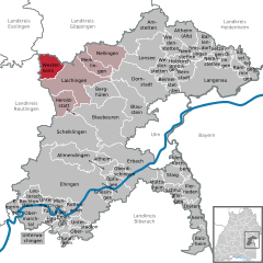
 | ||
| Coordinates: 48°30′54″N 9°37′25″E / 48.51500°N 9.62361°ECoordinates: 48°30′54″N 9°37′25″E / 48.51500°N 9.62361°E | ||
| Country | Germany | |
| State | Baden-Württemberg | |
| Admin. region | Tübingen | |
| District | Alb-Donau-Kreis | |
| Government | ||
| • Mayor | Hartmut Walz | |
| Area | ||
| • Total | 22.93 km2 (8.85 sq mi) | |
| Population (2015-12-31)[1] | ||
| • Total | 2,936 | |
| • Density | 130/km2 (330/sq mi) | |
| Time zone | CET/CEST (UTC+1/+2) | |
| Postal codes | 72589 | |
| Dialling codes | 07333 | |
| Vehicle registration | UL | |
| Website | www.westerheim.de | |

Location
Westerheim is a town in the district of Alb-Donau in Baden-Württemberg in Germany.
It is located at a height of 800 meters on the Swabian Alb, about 30 Kilometers north-west of Ulm.
History
Its origins stretch back to the Middle Ages. The Dukes of Helfenstein introduced the Reformation between 1555 and 1567, but Westerheim reverted to Catholicism. Today its inhabitants are mainly Roman Catholic, though the surrounding villages are Evangelical.
It was badly damaged in April 1945, when German Army units made a stand there. Before leaving they detonated their explosives which were stored in local barns (Stuttgart State Archives).
Economy
Westerheim is a Luftkurort (“fresh-air health resort”). It is a ski resort in the Winter. There is a large camping area nearby.
Sight-seeing
- The church of St. Stephen, constructed in 1777/1778, has a barock high altar.
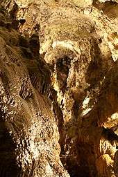
- The "Schertelshöhle" cave is a 212-meter long cave with stalactites. It is illuminated and can be visited daily from May to October.
- The "Steinerne Haus" (house of stone) is a 55-meter long cave with an 8-meter high entrance, located close to the Schertelshöhle. In winter hundreds of large icicles are formed here, which melt in the spring. Part of the cave is closed off in winter, to house hibernating animals.