Westmoreland Road goods yard
| Westmoreland Road goods yard | |
|---|---|
|
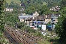
Former goods shed, now part of The Square, an office development on the site of the goods yard | |
| Location | |
| Place | Bath |
| Area | Bath and North East Somerset |
| Operations | |
| Original company | Great Western Railway |
| History | |
| 1877 | Depot opened |
| 1967 | Goods shed closed, sidings remain open for full loads |
| 1980 | Up-side sidings close |
| 1980s | Down-side sidings become refuse transfer terminal (Westmoreland Railhead) |
| 2011 | Refuse transfer terminal closes |
| Disused railway stations in the United Kingdom | |
|
Closed railway stations in Britain A B C D–F G H–J K–L M–O P–R S T–V W–Z | |
|
| |

Westmoreland Road goods yard was the main Great Western Railway goods station for the city of Bath in England, situated on the main line between the passenger stations of Oldfield Park and Bath (now Bath Spa).[1][2][3]
It took its name from Westmoreland Road, by which it stood. The official name of the station is uncertain. Railway historian Colin G. Maggs variously used Westmoreland Goods Yard, Westmoreland Road goods yard and Westmoreland Yard goods depot in his book covering this part of the Great Western Railway line.[4]
Railway Stations in Bath |
|---|
The goods depot was opened in 1877, freeing space at the constrained Bath Spa station site. A small engine shed was also moved from Bath Spa to Westmoreland in 1880. The goods depot was located on the up side of the line, fronting onto the Lower Bristol Road, opposite the Newark Works of crane makers Stothert & Pitt.[5] Further west on the down side towards Oldfield Park railway station, on the other side of Westmoreland Road, was located a goods loop and four sidings, called Bath West.[4]
One notable event was the unloading in 1903 of the special train for Buffalo Bill & His Wild West Show. A more frequent event putting heavy demands on the depot was whenever the Bath and West Show was held in Bath, and horse arrivals for the Bath Racecourse. In April 1942 German bombing caused major damage to the goods depot.[4]
Until 1911 the yard was controlled by two signal boxes, Westmoreland East and Westmoreland West. In 1911 these were replaced by a single signal box called Bath Goods.[4]
The Bath engine shed at Westmoreland closed in February 1961.[6] The goods depot closed in May 1967, but the sidings remained open for full loads until 31 December 1980. In the 1980s the goods depot was redeveloped into an office development called The Square, with the former goods shed converted into one of the office buildings.[7]
The down side sidings (Bath West) were developed as a refuse transfer terminal, called Westmoreland Railhead, by Avon County Council in the mid-1980s, taking waste to a landfill site in Calvert, Buckinghamshire.[4][8] The refuse transfer terminal remained in operation until 2011 when a new mechanical biological waste treatment plant opened in Avonmouth.[9]
References
- ↑ "The Newark Works and environs, Bath, 1946". Britain from Above. 2 October 1946. EAW002941. Retrieved 1 February 2015.
- ↑ "The Newark Works and the River Avon, Bath, from the west, 1946". Britain from Above. 2 October 1946. EAW002943. Retrieved 1 February 2015.
- ↑ "Bath Goods". Signalling Record Society. 8 February 2010. Retrieved 1 February 2015.
- 1 2 3 4 5 Colin G. Maggs (2013). The GWR Bristol To Bath. Amberley Publishing. ISBN 9781445625829. Retrieved 1 February 2015.
- ↑ Placemaking Areas: Bath Quays South - Newark Works and Riverside Court (PDF) (Report). Bath & North East Somerset Council. Retrieved 2 February 2015.
- ↑ "A Selection of Great Western Stations". The Great Western Archive. Retrieved 27 July 2011.
- ↑ "Report on Kingsmead House" (PDF). King Sturge. Bath and North East Somerset Council. 9 November 2010. Retrieved 21 August 2015.
- ↑ "Increase of staff at Bath Transfer Station and Pixash Lane HW&RC". Waste Management Sub Committee. Bath & North East Somerset Council. 19 March 2002. Retrieved 1 February 2015.
- ↑ "Official opening for £25m Avonmouth waste plant". BBC. 8 September 2011. Retrieved 2 February 2015.
External links
| Wikimedia Commons has media related to Westmoreland Road goods yard. |
- (photo) Two Hall class locos pass Bath goods depot sometime in the 1960s
- Freight Lease - Bath Westmoreland (site map), Network Rail, 9 April 2014
Coordinates: 51°22′41″N 2°22′02″W / 51.3781°N 2.3672°W