Westside (Gary)
In Gary, "West Side" may also refer collectively to the neighborhoods west of Broadway, including Westside, Downtown West, Brunswick, Ambridge Mann and Tolleston.
| Westside | |
|---|---|
| Neighborhood | |
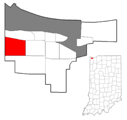 Location within the city of Gary | |
| Coordinates: 41°35′42″N 87°24′28″W / 41.594991°N 87.407868°WCoordinates: 41°35′42″N 87°24′28″W / 41.594991°N 87.407868°W | |
| Country |
|
| State |
|
| County | Lake County |
| City | Gary |
| Population (2000)[1] | |
| • Total | 6,153 |
| Time zone | CST (UTC-6) |
| • Summer (DST) | CDT (UTC-5) |
| ZIP code | 46406 |
| Area code(s) | 219 |
Westside (also spelled West Side) is a neighborhood in west-central Gary, Indiana, bounded by the Cline Avenue expressway on the west, the Norfolk Southern railroad on the north, Clark Road on the east and 25th Avenue on the south.[1] It lies directly east of the Hessville neighborhood of Hammond. Within Gary, it adjoins the neighborhoods of Brunswick, Tolleston, and Black Oak. As of 2000, Westside had a population of 6,153, which was 63.3% African-American and 31.9% white, with 10.1% Hispanic ethnicity.[1]
Much of the neighborhood's acreage is devoted to industrial and institutional uses, including a landfill.[1] Westside's housing stock is concentrated in the northeast and southern areas. As of 2000, its 2,340 housing units were 92% occupied and 60% owner-occupied.[1] Most development in the area occurred after 1960, giving it a younger housing stock than most other Gary neighborhoods.[2] As of 2007, the neighborhood had the third highest housing values in Gary, behind Miller and Ambridge Mann.[3]
The 1964 comprehensive plan for Gary had designated the entire Westside area for industrial use, but "the area was invaded by speculators, who built isolated housing tracts."[2] Construction continued into the 1970s, including some affordabe housing projects. Westside and Miller were the only neighborhoods in Gary to gain population between 1970 and 1980, when Westside's population reached 6,368.[4] However, crime soon became problematic; in 1984, when Westside was still largely middle-class, the Jewel supermarket serving the area closed down due to repeated thefts and robberies.[5] Today, retail business in Westside is quite limited, except for a retail cluster near the Burr Street exit of the Borman Expressway, on the boundary between Westside and Black Oak.[6]
Westside is home to an elementary school and West Side High School. There is an 8-acre city park, Seberger Park, near the neighborhood's southwestern corner.[7]
References
- Catlin, Robert A. (1993). Racial politics and urban planning: Gary, Indiana, 1980-1989.
- City of Gary (2008). City of Gary, Indiana Comprehensive Plan (PDF).
- Schoon, Kenneth J. (2003). Calumet Beginnings. ISBN 978-0-253-34218-8.
- 1 2 3 4 5 City of Gary 2008, p. 156.
- 1 2 Catlin 1993, p. 97.
- ↑ City of Gary 2008, p. 114.
- ↑ Catlin 1993, p. 90.
- ↑ Catlin 1993, p. 76.
- ↑ City of Gary 2008, p. 153.
- ↑ City of Gary. "Seberger". Retrieved 2011-06-10.