Wether Down
| Wether Down | |
|---|---|
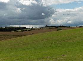 View from Wether Down towards Betterton Down | |
| Highest point | |
| Elevation | 234 m (768 ft) [1] |
| Prominence | 37 m (121 ft) [1] |
| Parent peak | Butser Hill [1] |
| Coordinates | 50°58′24″N 1°02′23″W / 50.9733°N 1.0396°WCoordinates: 50°58′24″N 1°02′23″W / 50.9733°N 1.0396°W |
| Geography | |
| Location | Hampshire, England |
| Parent range | South Downs |
| OS grid | SU675197 |
| Topo map | OS Landranger |
Wether Down is one of the highest hills in the county of Hampshire, England, and in the South Downs, rising to 234 metres (768 ft) above sea level.
Wether Hill is largely treeless and there is a trig point and transmission mast at the summit. Cross dykes and a long barrow in the vicinity provide evidence of prehistoric settlement in the area.[2]
References
- 1 2 3 Summit Listings by Relative Height by Mark Jackson, compiled by Jonathan de Ferranti. Accessed on 1 Apr 2013.
- ↑ Ordnance Survey 1:50,000 Landranger series.
This article is issued from Wikipedia - version of the 4/7/2013. The text is available under the Creative Commons Attribution/Share Alike but additional terms may apply for the media files.