Weymouth Street

Weymouth Street lies in the Marylebone district of the City of Westminster and connects Marylebone High Street with Great Portland Street. The area was developed in the late 18th century by Henrietta Cavendish Holles and her husband Edward Harley, 2nd Earl of Oxford. This part of Marylebone originally belonged to the Manor of Tyburn which existed at the time of the Domesday Book (1086).
History

The area of Marylebone in which Weymouth Street is located originally belonged to the Manor of Tyburn which existed at the time of the Domesday Book (1086).[1] Weymouth Street was first laid out and built up in the late 1770s and early 1780s in line with the development of Harley Street, Portland Place and Great Portland Street.[2] Approximately a century later, the street was partially rebuilt and modernised mainly with neoclassical architecture. At the beginning of the 1900s, following lease expiries, large mansion blocks were developed near the main intersections of the street.[3] During the London Blitz of 1940-41, the street was struck twice by high explosive bombs.[4] Some of the original 18th century buildings survive to this day, for example at 45-49 Weymouth Street.
Location

Weymouth Street lies in the Parish of St. Marylebone.[5] In administrative terms, the street lies within the City of Westminster's Marylebone High Street Ward as well as the Harley Street Conservation Area.[6] It is one of the four principal streets that cross eastern Marylebone and its renowned medical district in and around Harley Street.
Weymouth Street is part of a rectilinear grid and is crossed by Harley Street, Portland Place, and Hallam Street. The streets that join Weymouth Street on its north side are (east to west) Beaumont Mews, Beaumont Street, Upper Wimpole Street, and Devonshire Mews South. On its south side it is joined by Marylebone Street, Wesley Street, Westmoreland Street, Wimpole Street, Wimpole Mews, and Weymouth Mews.
Land ownership
Almost all of Weymouth Street is now part of the Howard de Walden Estate. Its eastern edge by Great Portland Street is controlled by the Langham Estate (on land once also part of the Howard de Walden Estate).[7]
Character

The street is known for its medical establishments, most notably The Harley Street Clinic built in 1935. Over time, larger institutional and residential buildings replaced earlier Georgian terraces at its intersections with Marylebone High Street, Portland Place and Great Portland Street. In contrast, central sections of the street still "retain much of their former domestic scale and character."[8] The street was lined with trees in 2010 as part of a neighbourhood community and stakeholder-based greening initiative.[9]
Notable Residents

Notable residents who have lived on Weymouth Street include Edward Foley (1747–1803), MP, the second son of Lord Foley, of Foley House [10] Ernest Vaughan, 4th Earl of Lisburne (no 40), James Butler, 1st Marquess of Ormonde (no 14), the portraitist Mary Grace, the actress Mary Wells (actress) (no 12), Michael Faraday (no 18), the writer Jane Marcet (no 49), while psychoanalyst Dr Estelle Maud Cole, journalist and broadcaster Gilbert Harding, the entertainer Hughie Green and the pathologist Professor Keith Simpson (the latter four all lived at no 1).[11]
Listed buildings
There are a large number of listed buildings in Weymouth Street, all of which are grade II. 69 Portland Place and 115 Harley Street, both of which are on the corner with Weymouth Street, are both grade II*. 22 Weymouth Street (1934) is notable for its combination of traditional and modernist architectural elements.[12] All of Weymouth Street lies within the Harley Street Conservation Area.[13]
Gallery
 Weymouth Street in 1905 looking east towards Great Portland Street.
 Barbara Windsor, actress, with local residents plants the last of 53 trees to be added to Weymouth Street in 2010.
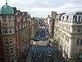 Photograph looking west down Weymouth Street in 2010.
References
- ↑ Howard de Walden Estate (undated) The history of Marylebone: from rural manor to urban village, via pleasure gardens and Georgian developers, available on http://www.hdwe.co.uk/about-marylebone-history.aspx, accessed 05 October 2016
- ↑ The western end of Weymouth Street was initially called Bowling Green Lane. It was built on the site of the bowling green of the old Marylebone Gardens which was a popular attraction until the late 18th century.
- ↑ Bartlett School of Architecture (2016 Draft) Chapter 15: Devonshire, Weymouth and New Cavendish Streets, Survey of London on South-East Marylebone, Vol. 51-2, pp.1-41.
- ↑ Air Raid Warden's Post D2 in the Borough of St Marylebone was located in the basement of the Royal Institute of British Architects' Building in Weymouth Street, just off Portland Place. Its records of these explosions have been noted on Bombsight (2013) Map of the London WW2 bomb census between 7/10/1940 and 06/06/1941, via http://bombsight.org/#17/51.52034/-0.14604, accessed 01/10/2016.
- ↑ Weymouth Street runs into Great Portland Street and Marylebone's boundary with Fitzrovia.
- ↑ "WCC Conservation Area Audit June 2008". Westminster City Council. Retrieved 2010-05-21.
- ↑ http://www.langhamestate.com/about-us/ Accessed 05/10/2016
- ↑ The Bartlett School of Architecture (2016 Draft) Chapter 15: Devonshire, Weymouth and New Cavendish Streets, Survey of London on South-East Marylebone, Vol. 51-2, pp.1-41.
- ↑ Barbara Windsor completes the planting of new trees on Weymouth Street https://w1wtrees.wordpress.com/2010/11/04/barbara-windsor-completes-the-planting-of-new-trees-on-weymouth-street/ The W1W Tree Planting Initiative for Marylebone, November 4, 2010, accessed 1 October 2016
- ↑ Lord Foley was cousin to Edward Harley, 2nd Earl of Oxford detail on link available on http://www.miketodd.net/other/bhhistory/bh_1755.htm accessed 08/10/2016
- ↑ Bartlett School of Architecture (2016) Survey of London on South-East Marylebone, Vol. 51-2, pp.2-4.
- ↑ Historic England. "22, Weymouth Street (1393317)". National Heritage List for England. Retrieved 6 October 2016.
- ↑ "Harley Street Conservation Area Map September 2007" (PDF). Westminster City Council. Retrieved 2010-05-21.
External links
| Wikimedia Commons has media related to Weymouth Street, London. |
- The Marylebone Association
- The Howard de Walden Estate
- The Langham Estate
- Westminster City Council Harley Street Conservation Area Audit 2008
- London Blitz report from Air Raid Warden Post D2 on Weymouth Street in St Marylebone
