Baker Street tube station
| Baker Street | |
|---|---|
|
Station entrance | |
 Baker Street Location of Baker Street in Central London | |
| Location | Marylebone |
| Local authority | City of Westminster |
| Managed by | London Underground |
| Station code | ZBS |
| Number of platforms | 10 |
| Fare zone | 1 |
| OSI |
Marylebone |
| London Underground annual entry and exit | |
| 2012 |
|
| 2013 |
|
| 2014 |
|
| 2015 |
|
| Key dates | |
| 1863 | Opened (MR) |
| 1868 | Opened (MR platforms to north) |
| 1906 | Opened (BS&WR, as terminus) |
| 1907 | Extended (BSWR – Marylebone) |
| 1939 | Started (Bakerloo to Stanmore) |
| 1961 | Ended (Met to Aylesbury) |
| 1979 | Ended (Bakerloo to Stanmore) |
| 1979 | Started (Jubilee line) |
| 1990 | Ended (Met to H'smith/Barking) |
| 1990 | Started (Hammersmith & City) |
| Listed status | |
| Listing grade | II* (since 28 June 2010) |
| Entry number | 1239815[3] |
| Added to list | 26 March 1987 |
| Other information | |
| Lists of stations | |
| External links | |
| WGS84 | 51°31′19″N 0°09′25″W / 51.522°N 0.157°WCoordinates: 51°31′19″N 0°09′25″W / 51.522°N 0.157°W |
|
| |

Baker Street is a station on the London Underground at the junction of Baker Street and the Marylebone Road. The station is in Travelcard Zone 1 and is served by five different lines.[4] It is one of the original stations of the Metropolitan Railway (MR), the world's first underground railway, opened in 1863.[5]
On the Circle and Hammersmith & City lines it is between Great Portland Street and Edgware Road. On the Metropolitan line it is between Great Portland Street and Finchley Road. On the Bakerloo line it is between Regent's Park and Marylebone, and on the Jubilee line it is between Bond Street and St. John's Wood.[4]
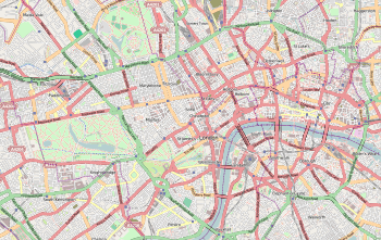
Location
The station has entrances on Baker Street, Chiltern Street (ticket holders only) and Marylebone Road. Nearby attractions include Regent's Park, Lord's Cricket Ground, the Sherlock Holmes Museum and Madame Tussauds.
The station today
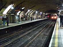
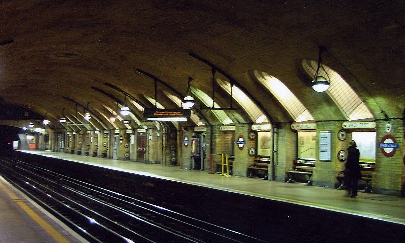
Of the MR's original stations, the sub-surface Circle and Hammersmith & City line platforms are the best preserved. Plaques along the platform show old plans and photographs of the station.[6]
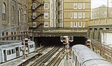
The station layout is rather complex. The sub-surface station is connected to the open-air Metropolitan line station. This is a terminus for some Metropolitan line trains, but there is also a connecting curve that joins to the Circle line just beyond the platforms, allowing Metropolitan line trains to run to Aldgate in the City of London. Below this is a deep-level tube station for the Bakerloo and Jubilee lines. These are arranged in a cross-platform interchange layout[7] and there are connections between the two lines just to the north of the station. Access to the Bakerloo and Jubilee lines is only via escalators.[8]
With ten platforms overall, Baker Street has the most London Underground platforms of any station on the network.[9] Since Swiss Cottage and St. John's Wood have replaced the former three stations between Finchley Road and Baker Street on the Metropolitan line, it takes an average of five and a half minutes to travel between them.[10]
Restoration work in the 1980s on the oldest portion of the Baker Street station brought it back to something similar to its 1863 appearance.[11]
Station improvements
Step-free access project
In 2008 TfL proposed a project to provide step-free access to the sub-surface platforms. The project was a TfL-funded Games-enabling project in its investment programme (and not a project specifically funded as a result of the success of the London 2012 Games bid).[12] The project was included in the strategy on accessible transport published by the London 2012 Olympic Delivery Authority and the London Organising Committee of the Olympic and Paralympic Games.[13]
Access to the Metropolitan line platforms 1–4 (serving trains to and from Finchley Road) would be provided by a bridge from the Bakerloo and Jubilee line ticket hall, with a lift from the bridge to each island platform. Through a passage from platforms 1–2, this would also give step-free access to platform 5 (Circle and Hammersmith & City line eastbound trains). Access to platform 6 (Circle and Hammersmith & City line westbound trains) would be provided by demolishing the triangular building outside the station, on the north side of Marylebone Road, and taking over the public pedestrian subway under Marylebone Road to provide a link between a lift up from platform 5 to the subway and a lift at the other end of the subway down to platform 6. The replacement for the triangular building would also act as an emergency exit for the station.[14]
TfL applied for planning permission and listed building consent for providing access to platforms 5 and 6 on 1 October 2008, but the application was subsequently withdrawn. (The part of the proposed scheme to provide step-free access to platforms 1–4 is within TfL's permitted development rights, and so does not require planning permission.)[15] TfL announced on 31 March 2009 that because of budgetary constraints the step-free scheme would be deferred.[16]
Platform lengthening
In order to accommodate the new, longer S stock trains, which started operating Metropolitan line services in August 2010, platforms 1 and 4 have been extended.[17] However, the Circle and Hammersmith & City line platforms 5 and 6 have not been extended to accommodate their new S7 Stock trains, due to the enclosed nature of the platforms. Instead selective door operation is employed.
Services
Bakerloo line
On this line, it is between Regent's Park and Marylebone.[4] Trains can terminate at Queen's Park, Stonebridge Park, or Harrow and Wealdstone to the north, and Piccadilly Circus, Lambeth North or Elephant & Castle to the south.[18]
The typical service pattern in trains per hour (tph) is:[19]
- 6tph to Harrow & Wealdstone via Queen's Park and Stonebridge Park (Northbound)
- 3tph to Stonebridge Park via Queen's Park (Northbound)
- 5tph to Queen's Park (Northbound)
- 14tph to Elephant & Castle (Southbound)
Circle line
The station is between Great Portland Street and Edgware Road on this line as well on the Hammersmith & City and Metropolitan lines.[4] The typical off-peak service in trains per hour (tph) is:
Hammersmith & City line
Between 1 October 1877 and 31 December 1906 some services on the H&CR were extended to Richmond over the London and South Western Railway (L&SWR) via its station at Hammersmith (Grove Road).[23][note 1]
The station is between Great Portland Street and Edgware Road on this line, as with the Circle and Metropolitan lines.[4] The typical off-peak service in trains per hour (tph) is:
Connections
The station is served by London Bus routes 2, 13, 18, 27, 30, 74, 82, 113, 139, 189, 205, 274 and 453,[26] and also by night routes N13, N18, N74, N113 and N205.[27] In addition, bus routes 27, 139, 189 and 453 have a 24-hour service.[26][27]
History
Metropolitan line

In the first half of the 19th century, the population and physical extent of London grew greatly.[note 2] The congested streets and the distance to the City from the stations to the north and west prompted many attempts to get parliamentary approval to build new railway lines into the City.[note 3] In 1852, Charles Pearson planned a railway from Farringdon to King's Cross. Although the plan was supported by the City, the railway companies were not interested and the company struggled to proceed.[33] The Bayswater, Paddington, and Holborn Bridge Railway Company was established to connect the Great Western Railway's (GWR) Paddington station to Pearson's route at King's Cross.[33] A bill was published in November 1852[34] and in January 1853 the directors held their first meeting and appointed John Fowler as its engineer.[35] Several bills were submitted for a route between Paddington and Farringdon.[36] The company's name was also to be changed again, to Metropolitan Railway[33][37][note 4] and the route was approved on 7 August 1854.[36][38]
Construction began in March 1860[39] with works mostly using the "cut-and-cover" method from Paddington to King's Cross; east of there it continued in a short tunnel then followed the culverted River Fleet in an open cutting to near the new Smithfield meat market.[40][41] Delayed by several accidents during construction,[42] work was complete by the end of 1862 at a cost of £1.3 million.[43] The railway opened to the public on Saturday 10 January 1863.[44][note 5] The Met was granted permission for two additional tracks (the City Widened Lines) from King's Cross to Farringdon Street in 1861, and a four-track eastward extension to Moorgate in 1864.[46][47][48][note 6] The extension to Aldersgate Street and Moorgate Street (now Barbican and Moorgate) opened on 23 December 1865.[50][note 7] On 13 April 1868, the MR opened the first section of Metropolitan and St John's Wood Railway as a branch from its existing route.[52] This line, serving the open-air platforms, was steadily extended to Willesden Green and northwards, finally reaching Aylesbury Town and Verney Junction (some 50 miles/80 km from Baker Street) in 1892.[52] The MR station mainly competed for traffic with Euston, where the LNWR provided local services to Middlesex and Watford, and later with Marylebone, where the GCR provided expresses to Aylesbury and beyond on the same line.
Over the next few decades this section of the station was extensively rebuilt to provide four platforms. The current Metropolitan line layout largely dates from 1925, and the bulk of the surface buildings, designed by architect Charles Walter Clark, also date from this period.
As part of the Transported by Design programme of activities, in 15 October 2015, after two months of public voting, Baker Street underground station's platforms were elected by Londoners as one of the 10 favourite transport design icons.[53][54]
Hammersmith & City line
In November 1860, a bill was presented to Parliament for a railway from the GWR's main line west of Paddington to Shepherd's Bush and Hammersmith.[55][56][note 8] Authorised on 22 July 1861 as the Hammersmith and City Railway (H&CR),[57] the line constructed[note 9] opened on 13 June 1864.[59][note 10] In 1871, two additional tracks parallel to the GWR between Westbourne Park and Paddington were brought into use for the H&CR.[58]
Circle line
Proposals from the Met to extend south from Paddington to South Kensington and east from Moorgate to Tower Hill were granted on 29 July 1864.[60][note 11] Starting as a branch from Praed Street junction, a short distance east of the Met's Paddington station, the western extension[note 12] opened to Brompton (Gloucester Road) (now Gloucester Road) on 1 October 1868.[63][24] Three months later, on 24 December 1868, the Met extended eastwards to South Kensington.[note 13]
.svg.png)
The two companies started operating a joint Inner Circle service between Mansion House and Moorgate Street via South Kensington and Edgware Road every ten minutes,[note 14] supplemented by a District service every ten minutes between Mansion House and West Brompton and H&CR and GWR suburban services between Edgware Road and Moorgate Street.[64] At the other end of the line, the District part of South Kensington station opened on 10 July 1871 [65][note 15] and Earl's Court station opened on the West Brompton extension on 30 October 1871.[24]
Bakerloo line and Jubilee line

In November 1891, a private bill was presented to Parliament for the construction of the Baker Street and Waterloo Railway (BS&WR).[67] The railway was planned to run entirely underground from Marylebone[68] to Elephant & Castle[69] via Baker Street and Waterloo[67] and was approved in 1900.[70][71] Construction commenced in August 1898[72] under the direction of Sir Benjamin Baker, W.R. Galbraith and R.F. Church[73] with building work by Perry & Company of Tredegar Works, Bow.[73][note 16] Test trains began running in 1905.[77] The official opening of the BS&WR by Sir Edwin Cornwall took place on 10 March 1906.[78] The first section of the BS&WR was between Baker Street and Lambeth North.[79] Baker Street was the temporary northern terminus of the line until it was extended to Marylebone on 27 March 1907, a year after the rest of the line.[5][79] The original station building stood on Baker Street and served the tube platforms with lifts, but these were supplemented with escalators in 1914, linking the Metropolitan line and the Bakerloo line platforms by a new concourse excavated under the Metropolitan line.[80]
On 20 November 1939, following the construction of an additional southbound platform and connecting tube tunnels between Baker Street and Finchley Road stations, the Bakerloo line took over the Metropolitan line's stopping services between Finchley Road and Wembley Park and its Stanmore branch.[52] The current Bakerloo ticket hall and escalators to the lower concourse were provided in conjunction with the new service.[81] The Jubilee line added an extra northbound platform and replaced the Bakerloo line service to Stanmore from its opening on 1 May 1979.[5][82]
Incidents
On 18 June 1925, electric locomotive No.4 collided with a passenger train when a signal was changed from green to red just as the locomotive was passing it. Six people were injured.[83]
On 23 August 1973, a bomb was found in a carrier bag in the ticket hall.[84] The bomb was defused by the bomb squad. A week later, on 30 August, a member of staff found another bomb left on the overbridge. Again, it was defused without any injury.[85]
Points of interest
In popular culture
The excavation of Baker Street for the Underground can be seen in a scene of the 2011 film Sherlock Holmes: A Game of Shadows, set in 1891.
See also
Notes and references
Notes
- ↑ The L&SWR tracks to Richmond now form part of the London Underground's District line. Stations between Hammersmith and Richmond served by the Met were Ravenscourt Park, Turnham Green, Gunnersbury, and Kew Gardens.[24]
- ↑ In 1801, approximately one million people lived in the area that is now Greater London. By 1851 this had doubled.[28] The increasing resident population and the development of a commuting population arriving by train each day led to a high level of traffic congestion with huge numbers of carts, cabs, and omnibuses filling the roads and up to 200,000 people entering the City of London, the commercial heart, each day on foot.[29]
- ↑ None were successful, and the 1846 Royal Commission investigation into Metropolitan Railway Termini banned construction of new lines or stations in the built-up central area.[30][31] The concept of an underground railway linking the City with the mainline termini was first proposed in the 1830s.[32]
- ↑ The original established name was the "North Metropolitan Railway".[36]
- ↑ The railway included a ceremonial run from Paddington and a large banquet for 600 shareholders and guests at Farringdon a day earlier.[45] These platforms are now served by the Circle and Hammersmith & City lines.[5]
- ↑ The Met used two tracks: the other two tracks, the City Widened Lines, used mainly by other railway companies.[49]
- ↑ All four tracks opened on 1 March 1866.[51]
- ↑ A connection to the West London Railway at Latimer Road was also proposed at the same time.[55][56]
- ↑ The line was constructed on a 20-foot (6.1 m) high viaduct largely across open fields.[58]
- ↑ The link to the West London Railway opened on 1 July that year, served by a carriage that was attached or detached at Notting Hill (now Ladbroke Grove) for Kensington (Addison Road).[59] The original Shepherd's Bush station was replaced by the current Shepherd's Bush Market station in 1914.[24]
- ↑ To complete the circuit, the committee encouraged the amalgamation of two schemes via different routes between Kensington and the City, and a combined proposal under the name Metropolitan District Railway (commonly known as the District railway) was agreed on the same day.[60][61]
- ↑ In Leinster Gardens, Bayswater, a façade of two five-storey houses was built at Nos. 23 and 24 to conceal the gap in a terrace created by the railway passing through. To ensure adequate ventilation, most of the line was in cutting except for a 421-yard (385 m) tunnel under Campden Hill.[62]
- ↑ The District also opened its line from there to Westminster, with other stations at Sloane Square, Victoria, St. James's Park, and Westminster Bridge (now Westminster).[24]
- ↑ Sources differ about the running of the first 'inner circle' services. Jackson 1986, p. 56 says the operation was shared equally, whereas Lee 1956, pp. 28–29 states the Met ran all the services.
- ↑ The station was completed on 19 July 1871, the Metropolitan and the District running a joint connecting bus service from the station to the 1871 International Exhibition.[66]
- ↑ By November 1899, the northbound tunnel reached Trafalgar Square and work on some of the station sites was started, but the collapse of the L&GFC in 1900 led to works gradually coming to a halt. When the UERL was formed in April 1902, 50 per cent of the tunnelling and 25 per cent of the station work was completed.[74] With funds in place, work restarted and proceeded at a rate of 73 feet (22.25 m) per week,.[75] By February 1904, most of the tunnels and underground parts of the stations between Elephant & Castle and Marylebone were complete and works on the station buildings were in progress.[76] The additional stations were incorporated as work continued elsewhere.[77]
References
- ↑ "Out-of-Station Interchanges" (Microsoft Excel). Transport for London. 2 January 2016. Retrieved 28 August 2016.
- 1 2 3 4 "Multi-year station entry-and-exit figures" (XLS). London Underground station passenger usage data. Transport for London. April 2016. Retrieved 3 May 2016.
- ↑ "Baker Street Station: Main Entrance Building and Metropolitan, Circle and Hammersmith & City line platforms (no. 1-6) including retaining wall to Approach Road". National Heritage List for England. English Heritage. Archived from the original on 10 April 2015.
- 1 2 3 4 5 Transport for London (January 2016). Standard Tube Map (PDF) (Map). Not to scale. Transport for London. Archived (PDF) from the original on 3 January 2015.
- 1 2 3 4 Rose, Douglas (1999). The London Underground, A Diagrammatic History. London: Douglas Rose/Capital Transport. ISBN 978-1-85414-219-1.
- ↑ Ian, Jones (6 January 2013). "76. The original platforms at Baker Street". 150 Great Things About the Underground. Archived from the original on 10 April 2015. Retrieved 10 April 2015.
- ↑ "Step free Tube Guide" (PDF). Transport for London. Archived (PDF) from the original on 3 June 2015.
- ↑ "Tube Stations that only have escalators". Tube Facts and Figures. Geofftech. Archived from the original on 3 April 2015. Retrieved 10 April 2015.
- ↑ "London Underground: 150 fascinating Tube facts". Telegraph. 9 January 2013. Archived from the original on 10 April 2015. Retrieved 10 April 2015.
- ↑ "Stations that it takes the longest to travel between". Tube Facts and Figures. Geofftech. Archived from the original on 3 April 2015. Retrieved 10 April 2015.
- ↑ Reid, T.R. (22 September 1999). "Sherlock Holmes honored with statue near fictional London home". The Washington Post. Retrieved 6 January 2013.
- ↑ "TfL's Transport Portfolio Executive Report for the London 2012 Olympic Games and Paralympic Games – Quarter 2 2007/08" (PDF). TfL. 2008. Archived (PDF) from the original on 25 April 2012.
- ↑ "Accessible Transport Strategy for the London 2012 Olympic and Paralympic Games" (PDF). London 2012. May 2008. p. 31. Archived (PDF) from the original on 21 November 2008.
- ↑ "Step-free access Baker Street station" (PDF). TfL. September 2008. Archived (PDF) from the original on 14 August 2013.
- ↑ "Planning – Application Summary 08/08647/FULL". Westminster City Council. 1 October 2008. Archived from the original on 14 August 2013.
- ↑ "TfL sets out £9.2bn 2009/2010 budget to deliver major improvements this year" (Press release). TfL. 31 March 2009. Archived from the original on 19 January 2012.
- ↑ "'S' stock making its mark". Modern Railways. London. December 2010. p. 46.
- ↑ http://www.davros.org/rail/culg/bakerloo.html#services
- ↑ http://content.tfl.gov.uk/wtt-40-bakerloo.pdf
- 1 2 Feather, Clive (13 December 2014). "Circle line". Clive's Underground Line Guides. Archived from the original on 13 February 2016. Retrieved 13 February 2016.
- ↑ "Circle line timetable: From Baker Street Underground Station to Great Portland Street Underground Station". Transport for London. Archived from the original on 13 February 2016. Retrieved 13 February 2016.
- ↑ "Circle line timetable: From Baker Street Underground Station to Edgware Road (Circle Line) Underground Station (anti-clockwise)". Transport for London. Archived from the original on 13 February 2016. Retrieved 13 February 2016.
- ↑ Simpson 2003, p. 43.
- 1 2 3 4 5 Rose 2007.
- 1 2 3 Feather, Clive (26 October 2015). "Hammersmith & City line". Clive's Undeground Line Guides. Retrieved 2 May 2016.
- 1 2 "Day buses from Baker Street and Marylebone" (PDF). 31 August 2013. Retrieved 14 March 2015.
- 1 2 "Night buses from Baker Street and Marylebone" (PDF). 31 August 2013. Retrieved 14 March 2015.
- ↑ "Total Population". A Vision of Britain Through Time. University of Portsmouth/Jisc. 2009. Retrieved 13 December 2015.
- ↑ Wolmar 2004, p. 22.
- ↑ Simpson 2003, p. 7.
- ↑ "Metropolitan Railway Termini". The Times (19277). 1 July 1846. p. 6. Retrieved 13 December 2015. (subscription required (help)).
- ↑ "Grand Central Railway Terminus". The Times (19234). 12 May 1846. p. 8. Retrieved 13 December 2015. (subscription required (help)).
- 1 2 3 Day & Reed 2008, p. 9.
- ↑ The London Gazette: no. 21386. p. 3480. 30 November 1852. Retrieved 21 April 2012.
- ↑ Green 1987, pp. 3–4.
- 1 2 3 "Fowler's Ghost" 1962, p. 299.
- ↑ The London Gazette: no. 21497. pp. 3403–3405. 25 November 1853. Retrieved 21 April 2012.
- ↑ The London Gazette: no. 21581. pp. 2465–2466. 11 August 1854. Retrieved 21 April 2012.
- ↑ Day & Reed 2008, p. 10.
- ↑ Jackson 1986, p. 24.
- ↑ Walford 1878.
- ↑ Wolmar 2004, p. 36.
- ↑ Wolmar 2004, pp. 30 & 37.
- ↑ Day & Reed 2008, p. 14.
- ↑ Wolmar 2004, p. 39.
- ↑ "Fowler's Ghost" 1962, p. 303.
- ↑ The London Gazette: no. 22529. pp. 2871–2872. 12 July 1861. Retrieved 5 May 2012.
- ↑ The London Gazette: no. 22537. pp. 3314–3315. 9 August 1861. Retrieved 5 May 2012.
- ↑ Jackson 1986, p. 130.
- ↑ Green 1987, p. 6.
- ↑ Jackson 1986, p. 47.
- 1 2 3 Feather, Clive. "Metropolitan line". Clive's Underground Line Guides. Archived from the original on 6 April 2015. Retrieved 10 April 2015.
- ↑ https://www.ltmuseum.co.uk/press-and-media/news/595-london-s-transport-design-icons-announced
- ↑ http://www.timeout.com/london/blog/transported-by-design-vote-for-your-favourite-part-of-london-transport-080415
- 1 2 Wolmar 2004, pp. 66–67.
- 1 2 Jackson 1986, p. 38.
- ↑ The London Gazette: no. 22532. pp. 2997–2998. 23 July 1861. Retrieved 6 Feb 2016.
- 1 2 Jackson 1986, pp. 39–40.
- 1 2 Jackson 1986, pp. 38–39.
- 1 2 Day & Reed 2008, p. 18.
- ↑ Horne 2006, pp. 5–6.
- ↑ Jackson 1986, pp. 52–53.
- ↑ Day & Reed 2008, p. 20.
- ↑ Jackson 1986, p. 56.
- ↑ Day & Reed 2008, p. 25.
- ↑ Jackson 1986, p. 57.
- 1 2 The London Gazette: no. 26225. pp. 6145–6147. 20 November 1891. Retrieved 2 December 2015.
- ↑ The London Gazette: no. 26767. pp. 4572–4573. 11 August 1896. Retrieved 15 July 2015.
- ↑ Badsey-Ellis 2005, pp. 84–85.
- ↑ Badsey-Ellis 2005, p. 56.
- ↑ The London Gazette: no. 27218. pp. 4857–4858. 7 August 1900. Retrieved 2 December 2015.
- ↑ Wolmar 2004, p. 168.
- 1 2 Lee, Charles E. (March 1956). "Jubilee of the Bakerloo Railway – 1". The Railway Magazine: 149–156.
- ↑ "The Underground Electric Railways Company Of London (Limited)". The Times (36738): 12. 10 April 1902. Retrieved 2 December 2015. (subscription required (help)).
- ↑ Day & Reed 2008, p. 69.
- ↑ "Railway And Other Companies – Baker Street and Waterloo Railway". The Times (37319): 14. 17 February 1904. Retrieved 2 December 2015. (subscription required (help)).
- 1 2 Wolmar 2004, p. 173.
- ↑ Horne 2001, p. 17.
- 1 2 Feather, Clive (30 December 2014). "Bakerloo line". Clive's Underground Line Guides. Archived from the original on 8 December 2015. Retrieved 2 December 2015.
- ↑ Horne, Mike (2001). The Bakerloo Line: An Illustrated History. London: Capital Transport. p. 38. ISBN 1-85414-248-8.
- ↑ Horne 2001, p. 48.
- ↑ Feather, Clive. "Bakerloo line". Clive's Underground Line Guides. Archived from the original on 2 April 2015. Retrieved 10 April 2015.
- ↑ Earnshaw, Alan (1989). Trains in Trouble: Vol. 5. Penryn: Atlantic Books. p. 20. ISBN 0-906899-35-4.
- ↑ "History of Baker Street Tube Station". Jessica Higgins. Archived from the original on 4 March 2012.
- ↑ Nick, Cooper (5 June 2006). "Attacks on the London Underground". The Underground at War. Archived from the original on 23 April 2010.
Bibliography
- Badsey-Ellis, Antony (2005). London's Lost Tube Schemes. Capital Transport. ISBN 185414-293-3.
- Day, John R.; Reed, John (2008) [1963]. The Story of London's Underground (10th ed.). Capital Transport. ISBN 978-1-85414-316-7.
- "Fowler's Ghost" (May 1962). Cooke, B.W.C, ed. "Railway connections at King's Cross (part one)". The Railway Magazine. Tothill Press. 108 (733).
- Green, Oliver (1987). The London Underground: An illustrated history. Ian Allan. ISBN 0-7110-1720-4.
- Horne, Mike (2006). The District Line. Capital Transport. ISBN 1-85414-292-5.
- Jackson, Alan (1986). London's Metropolitan Railway. David & Charles. ISBN 0-7153-8839-8.
- Lee, Charles E. (1956). The Metropolitan District Railway. The Oakwood Press. ASIN B0000CJGHS.
- Rose, Douglas (December 2007) [1980]. The London Underground: A Diagrammatic History (8th ed.). Capital Transport. ISBN 978-1-85414-315-0.
- Simpson, Bill (2003). A History of the Metropolitan Railway. Volume 1: The Circle and Extended Lines to Rickmansworth. Lamplight Publications. ISBN 1-899246-07-X.
- Walford, Edward (1878). New and Old London: Volume 5. British History Online. Retrieved 3 July 2012.
- Wolmar, Christian (2004). The Subterranean Railway: how the London Underground was built and how it changed the city forever. Atlantic. ISBN 1-84354-023-1.
External links
| Wikimedia Commons has media related to Baker Street tube station. |
- Oldest Portion of Baker Street Station
- "As shown in 1863". Science and Society.
- "As shown in 2004". Rail Fan Europe. (restoration) "Baker Street". Rail Fan Europe.
- "Photograph of the Jubilee line platform at Baker Street". Tube Photos.
- "Baker Street and Waterloo Railway entrance, demolished in 1964". London Transport Museum.
| Preceding station | Following station | |||
|---|---|---|---|---|
towards Harrow & Wealdstone | Bakerloo line | towards Elephant & Castle |
||
towards Hammersmith | Circle line | |||
| Hammersmith & City line | towards Barking |
|||
towards Stanmore | Jubilee line | towards Stratford |
||
| Metropolitan line | towards Aldgate |
|||
| Terminus | ||||
| Former services | ||||
| Preceding station | Following station | |||
towards Stanmore | Bakerloo line Stanmore branch (1939–1979) | towards Elephant & Castle |
||
| Metropolitan line | towards Aldgate |
|||
| Terminus | ||||
| Companies and organisations |
| ||||||||||||||||||
|---|---|---|---|---|---|---|---|---|---|---|---|---|---|---|---|---|---|---|---|
| Airports |
| ||||||||||||||||||
| Major stations |
| ||||||||||||||||||
| Roads |
| ||||||||||||||||||
| Ticketing | |||||||||||||||||||
| Other | |||||||||||||||||||
| Former BR sectors | |||||||||||||||||||
| |||||||||||||||||||