Wheal Rose

Coordinates: 50°15′N 5°13′W / 50.25°N 05.21°W
Wheal Rose is a village in Cornwall, England, United Kingdom, in the Redruth[1] and St Agnes Parishes.[2]
History and antiquities
Northwest of Wheal Rose was an Iron Age building, a terraced field system, and an excavation pit.[3][4] It was also used during the Roman period from 43 to 410 AD.[3]
Religion
Wheal Rose had a Bible Christian chapel.[5]
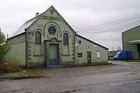 An old Methodist chapel, Wheal Rose
References
- ↑ Wheal Rose. Explore Britain. Retrieved 25 September 2012.
- ↑ Porthtowan and Wheal Rose. Neighbourhood profiles map. Cornwall Council. Retrieved 22 September 2012.
- 1 2 Monument No. 1137598 - Wheal Rose Area Iron Age building and terraced field. English Heritage National Monuments. Retrieved 21 September 2012.
- ↑ Monument No. 1137598 - Wheal Rose Area Iron Age building and terraced field - map. English Heritage National Monuments. Retrieved 21 September 2012.
- ↑ Church History. Mount Hawke. GENUKI. Retrieved 23 September 2012. Also see:Mount Hawke Parish Church.
External links
![]() Media related to Wheal Rose at Wikimedia Commons
Media related to Wheal Rose at Wikimedia Commons
This article is issued from Wikipedia - version of the 1/23/2016. The text is available under the Creative Commons Attribution/Share Alike but additional terms may apply for the media files.