Whiskey Dick Mountain
| Whiskey Dick Mountain | |
|---|---|
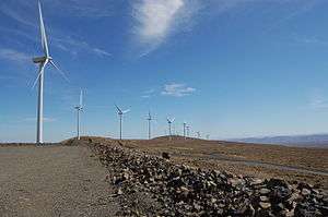 Wind turbines on Whiskey Dick Mountain | |
| Highest point | |
| Elevation | 3,873 ft (1,180 m) NGVD 29[1] |
| Prominence | 423 ft (129 m) [1] |
| Coordinates | 47°01′30″N 120°13′55″W / 47.0251284°N 120.2320051°WCoordinates: 47°01′30″N 120°13′55″W / 47.0251284°N 120.2320051°W [2] |
| Geography | |
 Whiskey Dick Mountain | |
| Parent range | Wenatchee Mountains |
| Topo map | USGS Whiskey Dick Mountain |
| Climbing | |
| Easiest route | Hike |
Whiskey Dick Mountain is located 15 miles (24 km) east of Ellensburg, in Washington state. Within the 28,549-acre (115.53 km2) Whiskey Dick Unit of the L.T. Murray Wildlife Area, it is the highest point on Windy Ridge.[3] The site of the Wild Horse Wind and Solar Facility is on its southwest flank. The farm, with 149 wind turbines, is owned by Puget Sound Energy.[4]
Access to land owned or leased by the power company is open to the public for recreational use by permit only.[5] The area, characterized by sagebrush steppe and rocky outcroppings, provides opportunities for hiking and hunting.[6]
See also
References
- 1 2 "Whiskey Dick Mountain, Washington". Peakbagger.com.
- ↑ "Whiskey Dick Mountain". Geographic Names Information System. United States Geological Survey.
- ↑ "Whiskey Dick Unit". Washington Department of Fish and Wildlife.
- ↑ "Wild Horse Wind and Solar Facility". Puget Sound Energy.
- ↑ "Wild Horse Access by written permission program". Puget Sound Energy.
- ↑ Sykes, Karen (April 21, 2005). "Hike Of The Week: Whiskey Dick's desert ramble can be a blast". Seattle Post-Intelligencer.
This article is issued from Wikipedia - version of the 2/2/2016. The text is available under the Creative Commons Attribution/Share Alike but additional terms may apply for the media files.