Whitechapel Road
Whitechapel Road is a major arterial road in Whitechapel, Tower Hamlets, in the East End of London. It is named after a small chapel of ease dedicated to St Mary and connects Aldgate to the west (as Whitechapel High Street) with Mile End Road to the east. The road is part of the historic Roman Road from London to Colchester, now the A11.
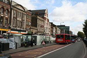
The road had become built up by the 19th century and is now a main shopping district in the Whitechapel area. There is an established street market along the road next to Whitechapel tube station. The Whitechapel Bell Foundry and the Royal London Hospital have been based on Whitechapel Road since the 18th century. It remains an important road and is marked with bus lanes, with limited parking.
Several ethnic minority communities have centred on Whitechapel Road. The road was a focal point of the Jewish Community from the 1850s to the 1930s, with many Jewish shops and market stalls. Towards the latter part of the 20th century, the street became an established settlement of the British Bangladeshi community, who now sell a range of authentic Asian food and clothes in the market and on shop fronts. Altab Ali Park sits on the site of the original church at the western end of Whitechapel Road, and is a memorial to an Asian worker who suffered a fatal racial attack in 1978.
Geography
The road's name, along with the area, is derived from the original 14th-century White Chapel.[1] It follows the section of the Roman road between Londinium (London) and Camulodunum (Colchester), which connected to the Pye Road to Venta Icenorum (Caistor St Edmund near Norwich).[2] The section of the Roman Road that is now Whitechapel Road is a Primary A-road, the A11, and has bus lanes running along its length.[3] Owing to the popularity of the market, parking is heavily restricted, limited to occasional parking metered spaces along the road.[4]
Cycle Superhighway CS2 runs along Whitechapel Road.[3] The nearest London Underground stations are Whitechapel station and Aldgate East station and the nearest National Rail station is Bethnal Green railway station. A number of local London Buses routes run along Whitechapel Road, including 25, 205 and 254.[5]
History

The road has been an important thoroughfare and coaching route for centuries. Whitechapel High Street and Whitechapel Road are named as such on John Rocque's Map of London, 1746, both marked as "White Chapel".[6] On John Cary's "Environs of London" of 1795 (published in his New Itinerary of 1798) there are properties on both sides of the road.[7] By the ninth edition in 1821, the road is shown as extensively built up.[8] In the mid-19th century, drovers steered livestock from local farms along the road towards Smithfield Market, causing considerable traffic congestion.[4][9] By the 1870s, the road had become extensively developed with properties along the entire stretch of the road.[10]
The Freedom Press Bookshop is on Angel Alley, No. 84b Whitechapel High Street, and was established in the 1880s by Peter Kropotkin and Charlotte Wilson as the first publishing house to deal with anarchism and radical publications. The press has been controversial, and was fire-bombed in 2013, but quickly reopened.[4][11] The Whitechapel Art Gallery on Whitechapel High Street opened in 1899. It was designed by Charles Harrison Townsend in 1895 and was the first major art gallery in East London. It has shown works of Jackson Pollock, Robert Rauschenberg and David Hockney. It continues to be the centre of the arts scene in the area.[12]

The Whitechapel Bell Foundry, a principal supplier of church bells in Britain, is based at No. 32–34 Whitechapel Road.[4] The buildings date from 1670 and are Grade II listed. Originally a coaching inn known as The Artichoke, it has been occupied by the foundry since 1738, replacing smaller premises on the north side of the road.[1][13] Davenant Foundation School moved to No. 173 Whitechapel Road in 1818. The school expanded with a new hall and classrooms in 1896, with further improvements in 1909. However, a decreasing child population meant that in 1965, the school moved to Loughton, Essex. The building remains on the north side and is Grade II listed.[14][15]
Continuing eastwards, Whitechapel tube station is on the north side of the road, alongside the street market. Behind the tube station is the former site of Blackwall Buildings a set of philanthropic houses built in 1890.[16] Just to the east of the market are almshouses at Trinity House, that were originally built in 1695 for retired seamen.[4]
Nearby is the former site of St. Mary's (Whitechapel Road) tube station. The station opened in March 1884 but its close proximity to both Whitechapel and Aldgate East tube stations made it superfluous, leading to its closure in April 1938.[17] It was used as an air raid shelter in World War II, but was destroyed by bombing in 1940.[18] Opposite to the south is the former Royal London Hospital building, built in 1740. The hospital suffered significant structural damage during World War II, but much of the 18th- and 19th-century architecture still remains. A new building now sits adjacent to the original.[19]

The Pavilion Theatre opened on Nos.191–193 Whitechapel Road, the site of a former clothes factory, in 1828. It was the first major theatre to open in the East End of London.[20] The original building was destroyed in a fire in 1856, and was replaced by a larger theatre that could accommodate over 1,000 people, becoming the centre of Yiddish theatre in Britain.[21] It closed in 1934.[22]
During the 1940s, the Metropolitan Police attempted to crack down on illegal gambling held in social clubs along Whitechapel Road. The Brancroft Social Club was based at No. 69,[23] and in March 1944, a police raid uncovered unlicensed horse and dog race betting which led to the arrest of the club's owner and 21 patrons.[24]
The Albion Brewery was first established at the eastern end of Whitechapel Road in 1808 by Richard Ivory, landlord of the Blind Beggar. In 1860, the brewery was rebuilt, producing an average of 133,000 barrels of beer a year. It closed in 1979.[25]
The Eastern District Post Office is based at the eastern end of Whitechapel Road, on the south side. This was the eastern terminus for the former London Post Office Railway (colloquially known as the "Mail Rail"), built to allow fast mail transfers across London. It closed in 2003.[26][27] Beyond this is Mile End Gate – where the road becomes Mile End Road; and was the site of the former toll gate.[7]
Community
The road has the been the centre of several ethnic minority groups in London. In the 1840s, many Irish emigrated to avoid the potato famine and began street selling at Whitechapel Market and along Whitechapel Road.[28]
The Jewish community settled on and around Whitechapel Road from the 1850s onwards.[29] In the 1880s, the community expanded rapidly as Ashkenazi Jews fled to Britain and took over many of the shops and market stalls on the street.[30] For the remainder of the century and much of the 20th, the road was the focal point of the community. The nearby Jewish Free School was, at one point, the largest educational establishment in the world, with over 4,300 pupils.[30] A fountain opposite the Royal London Hospital in memory of King Edward VII has the inscription "erected from subscriptions raised by Jewish inhabitants of East London".[1] On 4 October 1936, British Union of Fascists leader Oswald Mosley organised an anti-Jewish parade through the East End that included passing through Whitechapel Road, but was stopped by a crowd of protesters.[31] The sentiment against Jews in Whitechapel Road caused the community to dissolve from the 1930s onwards; the Pavilion Theatre closed and the Jewish Free School was destroyed in the Blitz during World War II.[32] The Yiddish newspaper The Jewish Times (Die Zeit) was produced at No. 135 Whitechapel Road from 1913 to 1936.[33]
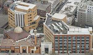
Towards the end of the 20th century, the street, along with nearby Brick Lane became the centre of the British Bangladeshi community. The East London Mosque on Whitechapel Road was opened by Shaykh Abdullah bin Subayl in 1985 and can accommodate over 3,000 worshippers, with dedicated facilities for women. The nearby London Muslim Centre opened in 2003.[1] Whitechapel Market caters well for the community, with stalls stocking Asian fruit and vegetables including okra and mangoes, clothing such as tunics and pashminas, and mobile phone cards for cheap long-distance calls.[34] A racially motivated attack on local worker Altab Ali near Whitechapel Road in May 1978 was a significant event for the local Asian community, and his life is now commemorated in Altab Ali Park at the western end of the road, which was built on the former St Mary's church grounds.[35][36]
Events
The area around Whitechapel Road is notorious for the 19th-century Whitechapel Murders, which are believed to be linked to Jack The Ripper. One of the first victims was Martha Tabram, who was found with multiple stab wounds on George Yard Buildings, Whitechapel Road on 7 August 1888.[28]
Joseph Merrick, the Elephant Man, moved to Whitechapel Road in 1884. Visitors paid to see him in the back room of a shop owned by showman Tom Norman. The shop was directly opposite the Royal London Hospital, and Merrick was frequently visited by doctors.[37] Merrick later moved to the hospital permanently, where he spent the last years of his life.[38]
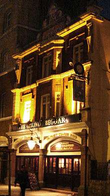
The Blind Beggar is at No. 337 and was the founding point of the Salvation Army following a meeting outside the pub by William Booth in 1865. On 9 March 1966, the venue became notorious after Ronnie Kray fatally shot George Cornell at the pub. The premises remains open for business, though it has been refurbished several times.[39] The Kray Twins also used the Blackwall Buildings, by then dilapidated, as a form of punishment by locking a victim in a flat alone with Ronnie's German Shepherd dog.[40]
Cultural references
Whitechapel Road is the equal cheapest property location on the British version of the Monopoly game board. Both it and the Old Kent Road are priced at £60. In reality, increasing property prices across London meant that the average house price on Whitechapel Road in 2013 was £295,082.[41]
See also
- Boar's Head Theatre, historic 17th-century theatre on Whitechapel High Street
- One Commercial Street
- Salomon v A Salomon & Co Ltd [1897] AC 22, the most famous UK company law case, about a business on Whitechapel High Street.
References
Citations
- 1 2 3 4 Hibbert & Weinreb 2010, p. 1018.
- ↑ Chaffey, Gareth (2011). "Learning Legacy: Lessons Learned from the London 2012 Games construction project" (PDF). Olympic Delivery Authority. Retrieved 19 February 2015.
- 1 2 "Section 2 – White Church Lane to Cambridge Heath Road". Barclays Superhighway 2. Transport for London. Retrieved 6 July 2015.
- 1 2 3 4 5 Harriss 2006, p. 121.
- ↑ "North to East London Bus Map" (PDF). Transport for London. Retrieved 6 July 2015.
- ↑ John Roque's Map of London (Map). 1746 – via Wikimedia.
- 1 2 Cary's New And Accurate Plan of London And Westminster (Map). 1795. Retrieved 6 July 2015.
- ↑ Environs of London (Map). Cary's New Itinerary. 1821. Retrieved 6 July 2015.
- ↑ Davis & Emeljanow 2005, p. 67.
- ↑ Bard 2014, p. 30.
- ↑ Gee, Tim (4 February 2013). "Britain's oldest radical bookshop is burned, but the ideas survive". The Guardian. Retrieved 7 July 2015.
- ↑ Bracken 2011, p. 18.
- ↑ "500 Years of History". Whitechapel Bell Foundry. Retrieved 3 July 2015.
- ↑ A History of the County of Middlesex. 1. London: Victoria County History. 1969. pp. 293–294.
- ↑ Townscape and Heritage (PDF) (Report). Tower Hamlets London Borough Council. Retrieved 3 July 2015.
- ↑ "Administrative County of London development plan: first review 1960". London County Council. 1962: 192.
- ↑ Bard 2014, p. 133.
- ↑ Long 2010, p. 108.
- ↑ Hibbert & Weinreb 2010, pp. 725–726.
- ↑ Davis & Emeljanow 2005, p. 55.
- ↑ Davis & Emeljanow 2005, p. 58.
- ↑ "Memories of London Yiddish Theatre" (PDF). Oxford Centre for Postgraduate Hebrew Studies. 14 August 1989. Retrieved 6 July 2015.
- ↑ "Advertisement of Cancelling" (PDF). The London Gazzette. 26 January 1932. p. 580. Retrieved 6 July 2015.
- ↑ "Club Raids, London". Hansard. 4 April 1944. Retrieved 6 July 2015.
- ↑ Richmond & Turton 1990, pp. 224–225.
- ↑ Samuel, Herbert (11 June 1913). "Post Office (London) Railway Bill". Hansard. Retrieved 3 July 2015.
- ↑ Dangerfield, Andy (28 January 2014). "Mail Rail: What is it like on the 'secret' tube". BBC News. Retrieved 3 July 2015.
- 1 2 Hibbert & Weinreb 2010, p. 1017.
- ↑ Snyder 2013, p. 105.
- 1 2 Moore 2003, p. 296.
- ↑ Moore 2003, p. 297.
- ↑ Moore 2003, p. 298.
- ↑ "Willing's Press Guide". T Skinner Directories. 1967: 68.
- ↑ Harriss 2006, pp. 121–122.
- ↑ Brooke, Mike (6 May 2015). "Altab Ali's racist murder in Whitechapel remembered 37 years on". East London Advertiser. Retrieved 3 July 2015.
- ↑ Moore 2003, p. 303.
- ↑ Howell & Ford 1992, pp. 72,75.
- ↑ Moore 2003, p. 294.
- ↑ Sullivan 2000, p. 26.
- ↑ Pearson 2011, p. 2280.
- ↑ "Real life prices on Monopoly Board revealed". The Daily Telegraph. 3 July 2013. Retrieved 3 July 2015.
Sources
- Bard, Robert (2014). Whitechapel & Stepney Through Time. Amberley Publishing Limited. ISBN 978-1-445-64212-3.
- Bracken, G. Byrne (2011). Walking Tour London: Sketches of the city’s architectural treasure. Marshell Cavendish. ISBN 978-9-814-43536-9.
- Davis, Jim; Emeljanow, Victor (2005). Reflecting the Audience: London Theatregoing, 1840–1880. University of Iowa Press. ISBN 978-1-587-29402-0.
- Hibbert, Christopher; Weinreb, Ben (2010). The London Encyclopedia. Pan MacMillan. ISBN 978-1-405-04924-5.
- Harriss, Phil (2006). London Markets. Gadogan Guides. New Holland Publishers. ISBN 978-1-860-11306-2.
- Howell, Michael; Ford, Peter (1992) [1980]. The True History of the Elephant Man (3rd ed.). London: Penguin Books. ISBN 0-14-016515-0.
- Long, Davie (2010). Little Book of the London Underground. The History Press. ISBN 978-0-752-46236-3.
- Moore, Tim (2003). Do Not Pass Go. Vintage. ISBN 978-0-099-43386-6.
- Pearson, John (2011). Notorious: The Immortal Legend of the Kray Twins. Random House. ISBN 978-0-099-50534-1.
- Richmond, Lesley; Turton, Alison (1990). The Brewing Industry: A Guide to Historical Records. Manchester University Press. ISBN 978-0-719-03032-1.
- Snyder, Saskia Coenen (2013). Building a Public Judaism: Synagogues and Jewish Identity in Nineteenth-Century Europe. Harvard University Press. ISBN 978-0-674-07057-8.
- Sullivan, Edward (2000). Evening Standard London Pub Bar Guide. Simon and Schuster. ISBN 978-0-684-86840-0.
External links
- LondonTown.com information
- Shops on Whitechapel Road, E1
- Whitechapel Road educational activity sheet (PDF)
Coordinates: 51°31′06″N 0°03′48″W / 51.51833°N 0.06333°W