Whitfords railway station
Whitfords | |||||||||||
|---|---|---|---|---|---|---|---|---|---|---|---|
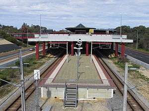 Southbound view in August 2014 | |||||||||||
| Location |
Mitchell Freeway, Padbury Australia | ||||||||||
| Coordinates | 31°47′58″S 115°46′56″E / 31.799318°S 115.782348°ECoordinates: 31°47′58″S 115°46′56″E / 31.799318°S 115.782348°E | ||||||||||
| Owned by | Public Transport Authority | ||||||||||
| Operated by | Transperth | ||||||||||
| Line(s) | Joondalup | ||||||||||
| Distance | 19.0 kilometres from Perth | ||||||||||
| Platforms | 2 (1 island) | ||||||||||
| Tracks | 2 | ||||||||||
| Bus routes | 18 | ||||||||||
| Bus stands | 8 | ||||||||||
| Construction | |||||||||||
| Structure type | Ground | ||||||||||
| Parking | 908 paid car bays | ||||||||||
| Disabled access | Yes | ||||||||||
| Other information | |||||||||||
| Station code |
JWS 99851 (platform 1) 99852 (platform 2) | ||||||||||
| Fare zone | 3 | ||||||||||
| History | |||||||||||
| Opened | 28 February 1993 | ||||||||||
| Electrified | Yes | ||||||||||
| Services | |||||||||||
| |||||||||||
Whitfords railway station is a railway station on the Transperth network. It is located on the Joondalup line, 19 kilometres from Perth station serving the suburb of Padbury.
History
Design and construction
At the time of the station's design, it was recognised by The Urban Rail Electrification Committee that the placement of bus services in close proximity or direct connection to rail infrastructure was of significant importance. This was evidenced by the Kelmscott and Armadale stations, and the then recently completed Cannington station.[1]
Under the Northern Suburbs Transit System Project, construction on the station was scheduled to commence on 16 November 1991, with completion expected by the end of December 1992. Warwick station being of exactly the same design was scheduled for construction in synchronisation with Whitfords station.[2]
The station was to include a number of facilities, including a bus concourse to connect with feeder bus services, information booths and offices for railway staff, amenities and services, as well as access services for mobility impaired passengers in line with design requirements of the time. Further to this, pieces of the Passenger Information Network installed at the station included previously unseen electronic displays on the upper bus decks designed to provide drivers with information so they could connect with appointed trains or communicate with bus depot control in the event of delays.[1]
North of the station a headshunt was laid for terminating trains. Even though the siding is in the middle of the Mitchell Freeway with no pedestrian access, Transperth were forced to fence the area in 2006 due to repeated graffiti attacks while trains were briefly in the siding.[3] Car parking spaces were also included as part of the construction project, which included a significant number of on-grade parking bays on the eastern side of the station for commuter use.[1]
The design of the station also allowed for the possible extension of the upper bus deck in a northern direction towards Whitfords Avenue.[1] This extension would provide for five additional regular bus bays, as well as additional pedestrian access if required.[2]
The most interesting part of the station was the upper bus deck. The deck was constructed of precast concrete that was formed off site, which was then transported to the site before being placed atop columns constructed as part of the stations foundations. Precast concrete flooring was then put in place, held in specially formed ridges running the length of the beams. This upper deck was the most expensive structural element of the station, and was the cause of significant attention and consideration as part of the design and construction process.[2]
Whitfords station opened on 28 February 1993.[3][4][5]
Services
Whitfords station is served by Transperth Joondalup line services.[6]
Platforms
Platforms currently in use are as follows:
| Stop | Platform | Line | Stopping pattern | Destination | Notes |
|---|---|---|---|---|---|
| 99851 | 1 | Joondalup | All station, A | Perth Underground | Shuttle weekdays only, terminus of shuttle (Pattern W) |
| 99852 | 2 | Joondalup | All stations | Butler | |
| K | Clarkson |
Bus routes
The top level of the station is a bus station serving the surrounding district.
| Stop | Route | Destination / description | Notes |
|---|---|---|---|
| [18477] Stand 1 | 352 | to Landsdale via Madeley[7] | |
| 467 | to Joondalup station via Hocking & Ashby[8] | ||
| 468 | to Joondalup station via Wanneroo Road[9] | ||
| 469 | to Wangara via Prindiville Drive & Motivation Drive[10] | ||
| [18478] Stand 2 | 441 | to Warwick station via Seacrest Drive[11] | |
| 442 | to Warwick station via Marmion Avenue & Poynter Drive[12] | ||
| [18479] Stand 3 | 443 | to Warwick station via Giles Avenue[13] | |
| 444 | to Warwick station via Gibson Avenue[14] | ||
| 904 | Rail replacement service to Perth station | ||
| 904 | Rail replacement service to Butler station | ||
| [18480] Stand 4 | 445 | to Warwick station via Kingsley & Coolibah Drives[15] | |
| 446 | to Warwick station via Barridale Drive & Allenswood Road[16] | ||
| [18473] Stand 5 | 447 | to Warwick station via Moolanda Boulevard & Cockman Road[17] | |
| [18474] Stand 6 | 460 | to Joondalup station via Oceanside Prom[18] | |
| 461 | to Joondalup station via Dampier Avenue[19] | ||
| [18475] Stand 7 | 462 | to Joondalup station via Bridgewater Boulevard[20] | |
| 463 | to Joondalup station via Gradient Way[21] | ||
| [18476] Stand 8 | 464 | to Joondalup station via Eddystone Avenue[22] | |
| 465 | to Joondalup station via Trappers Drive[23] | ||
| 466 | to Joondalup station via Timberlane Drive[24] |
References
- 1 2 3 4 Northern Suburbs Transit System; Perth to Joondalup Railway; Progress Summary - June 1991. Perth: The Urban Rail Electrification Committee, Government of Western Australia. 1991. pages 2, 20 Accessed at J S Battye Library, Perth
- 1 2 3 Design Development; Northern Suburbs Transit System; Warwick Transfer Station for Perth Electric - Perth Urban Rail Development. Perth: Anthony Brand, Brand Dekyn and Hay - Architects. 1991.Accessed at Battye Library, Perth
- 1 2 History of Stations on the Clarkson Train Line Right Track
- ↑ Bus/train interchanges on northern subs railway to open February Minister for Transport 28 January 1993
- ↑ Transperth (21 March 1993). Bus Timetable - J11. Accessed at J S Battye Library, Perth
- ↑ Joondalup Line Timetable Transperth 31 January 2016
- ↑ "Route 352". Bus Timetable 80 (PDF). Transperth. n.d. [effective from 9 October 2016].
- ↑ "Route 467". Bus Timetable 73 (PDF). Transperth. n.d. [effective from 9 October 2016].
- ↑ "Route 468". Bus Timetable 73 (PDF). Transperth. n.d. [effective from 9 October 2016].
- ↑ "Route 469". Bus Timetable 73 (PDF). Transperth. n.d. [effective from 9 October 2016].
- ↑ "Route 441". Bus Timetable 63 (PDF). Transperth. n.d. [effective from 31 January 2016].
- ↑ "Route 442". Bus Timetable 63 (PDF). Transperth. n.d. [effective from 31 January 2016].
- ↑ "Route 443". Bus Timetable 84 (PDF). Transperth. n.d. [effective from 31 January 2016].
- ↑ "Route 444". Bus Timetable 84 (PDF). Transperth. n.d. [effective from 31 January 2016].
- ↑ "Route 445". Bus Timetable 64 (PDF). Transperth. n.d. [effective from 31 January 2016].
- ↑ "Route 446". Bus Timetable 64 (PDF). Transperth. n.d. [effective from 31 January 2016].
- ↑ "Route 447". Bus Timetable 64 (PDF). Transperth. n.d. [effective from 31 January 2016].
- ↑ "Route 460". Bus Timetable 65 (PDF). Transperth. n.d. [effective from 17 July 2016].
- ↑ "Route 461". Bus Timetable 65 (PDF). Transperth. n.d. [effective from 17 July 2016].
- ↑ "Route 462". Bus Timetable 65 (PDF). Transperth. n.d. [effective from 17 July 2016].
- ↑ "Route 463". Bus Timetable 66 (PDF). Transperth. n.d. [effective from 9 October 2016].
- ↑ "Route 464". Bus Timetable 66 (PDF). Transperth. n.d. [effective from 9 October 2016].
- ↑ "Route 465". Bus Timetable 66 (PDF). Transperth. n.d. [effective from 9 October 2016].
- ↑ "Route 466". Bus Timetable 66 (PDF). Transperth. n.d. [effective from 9 October 2016].
External links
![]() Media related to Whitfords railway station at Wikimedia Commons
Media related to Whitfords railway station at Wikimedia Commons
Whitfords
Zone 3
| Preceding station | Transperth Trains network | Following station | ||
|---|---|---|---|---|
Zone 2 towards Elizabeth Quay | Joondalup Line All, K | Zone 3 towards Butler |
||
| Joondalup Line W | Terminus |
| Central area | |
|---|---|
| Northern area | |
| Eastern area | |
| Western area | |
| South eastern area | |
| Southern area | |
| Former stations | |
| Bus routes | |
Bus stations marked with | |