Wierden
| Wierden | |||
|---|---|---|---|
| Municipality | |||
|
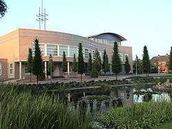
Wierden city hall | |||
| |||
.svg.png) Location in Overijssel | |||
| Coordinates: 52°21′N 6°36′E / 52.350°N 6.600°ECoordinates: 52°21′N 6°36′E / 52.350°N 6.600°E | |||
| Country | Netherlands | ||
| Province | Overijssel | ||
| Government[1] | |||
| • Body | Municipal council | ||
| • Mayor | Henk Robben (CDA) | ||
| Area[2] | |||
| • Total | 95.39 km2 (36.83 sq mi) | ||
| • Land | 94.77 km2 (36.59 sq mi) | ||
| • Water | 0.62 km2 (0.24 sq mi) | ||
| Elevation[3] | 11 m (36 ft) | ||
| Population (May 2014)[4] | |||
| • Total | 23,932 | ||
| • Density | 253/km2 (660/sq mi) | ||
| Demonym(s) | Wierdenaar | ||
| Time zone | CET (UTC+1) | ||
| • Summer (DST) | CEST (UTC+2) | ||
| Postcode | 7464–7469, 7640–7649 | ||
| Area code | 0546, 0547, 0548 | ||
| Website |
www | ||

Wierden (![]() pronunciation ) is a town and a municipality in the eastern Netherlands, in the province of Overijssel.
pronunciation ) is a town and a municipality in the eastern Netherlands, in the province of Overijssel.
The municipality of Wierden also includes the following towns, villages and townships: Enter, Hoge Hexel, IJpelo, Notter, Rectum (Wierden) Zuna.
The municipality has 10 primary schools and 1 secondary school. There are 2 soccer clubs, 2 tennis clubs and 1 volleyball club, this is only the top of the clubs. The village has 3 cemeteries in total of which, only one is currently in use. The major is Henk Robben, who is also the chair of the board of major and aldermen.
In midsummer the locally known, 3-day festival "WieZo" is held. Which starts on a Thursday and ends Saturdays. Every night there are 2 musical acts on the Binnenhof. On Saturday there is also the Wiezoloop.
International relations
Twin towns — sister cities
Wierden is twinned with:
Since September 2010, the town council decided to stop the cooperation between the municipalities because of the high costs and too low benefit.
Gallery
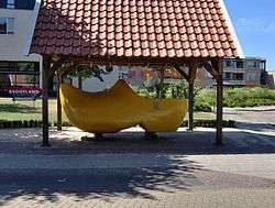
 World's largest wooden shoe made out of one piece of wood, in the Guinness Book of Records since June 26, 1991. It stands in the village of Enter, Netherlands
 'Gaanzendriewer' (Geese driver) by Piet Brouwer in front of the Klompenmuseum 't Schöpke
Notable residents
- Berthil ter Avest (1970), soccer player
- Loes Haverkort (1981), actress
- Anton Huiskes (1928–2008), ice-skater and trainer (national team)
- Jos Lammertink (1958), cyclist
- Jan Pouls (1964), soccer player
- Johanna ter Steege (1961), actress
- Eddy Zoëy (1967), radio- and TV presenter and singer
References
- ↑ "Wie zit er in het college van b&w?" [Who is member of the board of mayor and aldermen?] (in Dutch). Gemeente Wierden. Retrieved 2 April 2014.
- ↑ "Kerncijfers wijken en buurten" [Key figures for neighbourhoods]. CBS Statline (in Dutch). CBS. 2 July 2013. Retrieved 12 March 2014.
- ↑ "Postcodetool for 7642EB". Actueel Hoogtebestand Nederland (in Dutch). Het Waterschapshuis. Retrieved 2 April 2014.
- ↑ "Bevolkingsontwikkeling; regio per maand" [Population growth; regions per month]. CBS Statline (in Dutch). CBS. 26 June 2014. Retrieved 24 July 2014.
External links
 Media related to Wierden at Wikimedia Commons
- Official website
 |
Hellendoorn | Twenterand |  | |
| Hellendoorn Rijssen-Holten |
|
Almelo | ||
| ||||
| | ||||
| Hof van Twente |


