Wilby, Suffolk
| Wilby | |
 Church of St Mary |
|
 Wilby |
|
| Population | 231 [1] |
|---|---|
| OS grid reference | TM242721 |
| District | Mid Suffolk |
| Shire county | Suffolk |
| Region | East |
| Country | England |
| Sovereign state | United Kingdom |
| Post town | Eye |
| Postcode district | IP |
| Dialling code | 01379 |
| Police | Suffolk |
| Fire | Suffolk |
| Ambulance | East of England |
| EU Parliament | East of England |
| UK Parliament | Central Suffolk and North Ipswich |
Coordinates: 52°18′04″N 1°17′10″E / 52.301°N 1.286°E
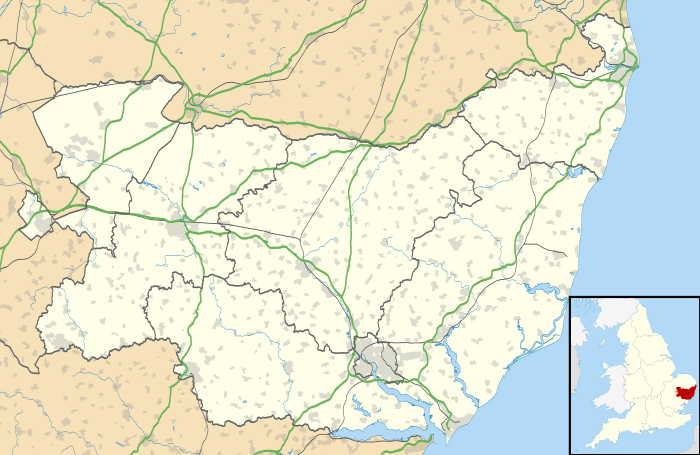
Wilby is a village and civil parish in the Mid Suffolk district of Suffolk in eastern England located around 9 miles (14 km) miles south-east of Diss and 1.25 miles (2 km) south of Stradbroke along the B1118. The population of the parish at the 2001 census was 231 in 99 households.[1] The village has some basic services including a primary school and village hall.[2] The name of the village is generally believed to be derived from the Old English meaning 'Ring of Willows'.[2][3] The village is mentioned in the Domesday Book at which time it had a small population of around 7 households and formed part of the holding of Bishop William of Thetford.[4] The nearest villages are Brundish, Laxfield, Stradbroke and Worlingworth.
Foals Green, Russel's Green, Stanway Green and Wootten Green (part) form part of the village which is dispersed in nature.
Church
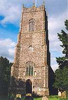
The village church is dedicated to St Mary.[5] It is medieval in origin and includes a 15th Century tower and a series of bench ends from the same century which are one of the finest collections in East Anglia.[6] The current vicar is Rev'd Canon Fiona who hold one Sunday service a week and publishes the Wilby and Brundish Newsletter.[7][8] St Mary's is a Grade I listed building.<refNewtonname="listchurch" /> Wilby Hall, a Grade II listed building, is a 16th Century farmhouse with an intact medieval moat.[9]
School
The village school serves around 100 children aged 5 to 11.[10] It is currently judged as 'Good' by Ofsted and has a link to a school in Mbauro in Kenya.[11] At 11 children usually transfer to Stradbroke High School.[10]
Village hall
Coronation Hall is the name of the village hall. It stands opposite the school near the centre of Wilby on the B1118. It was officially opened on Saturday 28 May 1955. It was one of the first village halls in suffolk to be made by voluntary labour. It is a memorial of the coronation of Her Majesty Queen Elizabeth II.[12]
Transport
Between 1908 and 1952 the village was served by Wilby railway station on the Mid-Suffolk Light Railway with the nearest operational railway station now at Diss.
References
- 1 2 2001 Census profiles, Suffolk County Council. Retrieved 2011-04-29.
- 1 2 Welcome to Wilby's Website, Wilby Parish Council. Retrieved 2011-04-29.
- ↑ "Onesuffolk Home". Retrieved May 11, 2012.
- ↑ Wilby, Domesday Map. Retrieved 2011-04-29.
- ↑ St Mary, Wilby, Suffolk Churches. Retrieved 2011-04-29.
- ↑ Church of St Mary, Wilby, British Listed Buildings. Retrieved 2011-04-29.
- ↑ "Parish Newsletters". GB: Wilby.onesuffolk.net. Retrieved 2012-08-08.
- ↑ "Church". GB: Wilby.onesuffolk.net. Retrieved 2012-08-08.
- ↑ Wilby Hall, Wilby, British Listed Buildings. Retrieved 2011-04-29.
- 1 2 Wilby CEVCP School, Suffolk County Council school profile. Retrieved 2011-04-29.
- ↑ Ofsted letter, 2010-07-12. Retrieved 2011-04-29.
- ↑ "The Village Hall Website". Retrieved May 18, 2011.
- ↑ "T G Askew". Retrieved May 20, 2012.
External links
![]() Media related to Wilby, Suffolk at Wikimedia Commons
Media related to Wilby, Suffolk at Wikimedia Commons