Willow Springs Lake
| Willow Springs Lake | |
|---|---|
 | |
| Location | Coconino County, Arizona, US |
| Coordinates | 34°18′12.78″N 110°52′14.1954″W / 34.3035500°N 110.870609833°WCoordinates: 34°18′12.78″N 110°52′14.1954″W / 34.3035500°N 110.870609833°W |
| Type | Reservoir |
| Primary inflows | Snowpack |
| Primary outflows | Willow Springs Canyon |
| Basin countries | United States |
| Surface area | 158 acres (640,000 m2)[1][2] |
| Average depth | 60 ft (18 m)[1] |
| Surface elevation | 7,513 ft (2,290 m)[2] |
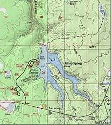
Willow Springs Lake is a cold water lake located on top of the Mogollon Rim in northern Arizona, about 23 mi (37 km) east of the city of Payson in the Apache-Sitgreaves National Forest, immediately adjacent to SR 260. It is a canyon-bound lake located on the Mogollon Rim, and is part of the collectivity known as the Rim Lakes. It can be found upstream from Chevelon Canyon Lake. The facilities are maintained by Apache-Sitgreaves National Forest division of the USDA Forest Service.[1]
Description
In 1967, The Arizona Game and Fish Department created Willow Springs Lake in order to provide water based recreational opportunities for the public. Willow Springs Lake is small and moderately deep with an average depth of 60 ft (18 m) and a surface area of 158 acres (640,000 m2). Boat motors are restricted to electric or 10 hp or less gas motors. From May through September the lake is regularly stocked with rainbow trout.[1] Self-sustaining largemouth bass, smallmouth bass, and green sunfish can also be found in the lake.[2] Ice fishing is a popular sport on the lake for anglers during the winter months.[3] According to the AZ Game and Fish Department, "Willow Springs Lake is one of the most visited lakes in the region, due in part to its proximity to the Phoenix area and cool temperatures".[1]
The lake is well developed, having 26 maintained campsites at Sinkhole Campground, barrier-free toilets, two picnic ramadas, two boat benches, and paved boat ramp access located on the west side of the lake at the main access point.[1] Willow Springs Lake is accessible via paved Forest Road 149 from April through November. From December through March, the lake freezes over and is inaccessible for vehicles. The lake can also be accessed via a dirt road to Sardine Point between the two arms of the lake, or by hiking to the upper ends of the two arms from SR 260.[2]
Willow Springs Lake has no permanent inflow, but receives enough snow melt every year to keep the lake full. The Arizona Game and Fish Department holds sole water rights to the lake. Unless spill-off occurs during the spring, no water is released downstream for irrigation or other uses. Most of the year, no spill occurs. When spill occurs, it drains down Willow Springs Canyon for 3.4 miles and merges with Woods Canyon to form Chevelon Creek. Chevelon Creek has seasonal water flow for 12.2 miles down to Chevelon Canyon Lake.[2]
Fish species
- Rainbow Trout[1][2]
- Largemouth Bass[1][2]
- Smallmouth Bass[1][2]
- Green Sunfish[2]
- Brown Trout[2]
- Crayfish[2]
External links
References
- 1 2 3 4 5 6 7 8 9 "Willow Springs Lake" (PDF). Arizona Game and Fish Department. Retrieved 2013-12-28.
- 1 2 3 4 5 6 7 8 9 10 11 "Middle Little Colorado River Sub-Watershed" (PDF). U.S. Fish and Wildlife Service, Arizona Game and Fish Department. Retrieved 2013-12-31.
- ↑ "Willow Springs Lake Fishing and Boating Site". U.S. Forest Service. Retrieved 2013-12-31.