Wisła Mała
| Wisła Mała | ||
|---|---|---|
| Village | ||
|
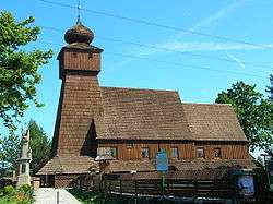
Saint James church | ||
| ||
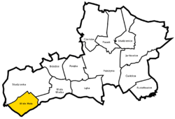 Location of Wisła Mała within Gmina Pszczyna | ||
 Wisła Mała Location of Wisła Mała within Gmina Pszczyna | ||
| Coordinates: 49°57′N 18°48′E / 49.950°N 18.800°ECoordinates: 49°57′N 18°48′E / 49.950°N 18.800°E | ||
| Country |
| |
| Voivodeship | Silesian | |
| County | Pszczyna | |
| Gmina | Pszczyna | |
| Population | 1,295 | |

Wisła Mała [ˈviswa ˈmawa] (German: Deutsch Weichsel) is a village in the administrative district of Gmina Pszczyna, within Pszczyna County, Silesian Voivodeship, in southern Poland.[1] It lies approximately 12 kilometres (7 mi) west of Pszczyna and 37 km (23 mi) south-west of the regional capital Katowice. The village has a population of 1,295.
History
The village of Wisła was first mentioned in 1223 as Vizla, in a document of Bishop of Wrocław issued for Norbertine Sisters in Rybnik among villages paying them tithe.[2][3] It belonged then to the Duchy of Opole and Racibórz and Castellany of Cieszyn. Later it belonged together with Wisła Wielka to the state country of Pszczyna.
References
- ↑ "Central Statistical Office (GUS) - TERYT (National Register of Territorial Land Apportionment Journal)" (in Polish). 2008-06-01.
- ↑ Panic, Idzi (2000). "Z badań nad osadami zanikłymi na Górnym Śląsku w średniowieczu. Uwagi w sprawie istnienia zaginionych wsi podcieszyńskich, Nageuuzi, Suenschizi, suburbium, Radouiza, Zasere, Clechemuje oraz Novosa". Pamiętnik Cieszyński. Polskie Towarzystwo Historyczne Oddział w Cieszynie (15): 29–37. ISSN 0137-558X. Retrieved 7 December 2012.
- ↑ Panic, Idzi (2010). Śląsk Cieszyński w średniowieczu (do 1528) [Cieszyn Silesia in Middle Ages (until 1528)] (in Polish). Cieszyn: Starostwo Powiatowe w Cieszynie. p. 294. ISBN 978-83-926929-3-5.
| Wikimedia Commons has media related to Wisła Mała. |
| Town and seat | ||
|---|---|---|
| Villages | ||
This article is issued from Wikipedia - version of the 6/9/2015. The text is available under the Creative Commons Attribution/Share Alike but additional terms may apply for the media files.