Wolfram, Queensland

Wolfram was a mining town in Queensland, Australia. It was about 90 kilometres (56 mi) west of Cairns and 15 kilometres (9.3 mi) south of Thornborough.[1] It was also known as Wolfram Camp. It is at an altitude of approximately 538 metres.[2] It is within the locality of Dimbulah in the Shire of Mareeba.
History
The mineral wolfram (from which the town derives its name) was discovered in the area in 1891 and attracted miners from neighbouring mining regions such as Thornborough and the Palmer River, forming a settlement known initially as Wolfram Camp.[1]
Wolfram today
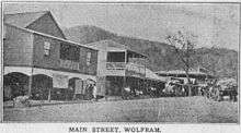
Today there are few visible remains of the settlement. There are some concrete foundations of long-gone buildings, headstones in the cemetery, and a row of mango trees that mark where the school used to be.[1][2]
Heritage listings
Wolfram has a number of sites listed on the Queensland Heritage Register including:
- Main Street: La Société Française des Métaux Rares treatment plant[3]
- Wolfram Road: Thermo Electric Ore Reduction Corporation Mill[4]
Notable people
- Bunny Adair, Member of the Queensland Legislative Assembly for Cook was born in Wolfram
References
- 1 2 3 "Wolfram". Queensland Places. Centre for the Government of Queensland, University of Queensland. Retrieved 2 February 2014.
- 1 2 "Wolfram Camp". Bonzle. Digital Atlas Pty Limited. Retrieved 2 February 2014.
- ↑ "La Société Française des Métaux Rares treatment plant (former) (entry 602583)". Queensland Heritage Register. Queensland Heritage Council. Retrieved 14 July 2013.
- ↑ "Thermo Electric Ore Reduction Corporation Mill (entry 602240)". Queensland Heritage Register. Queensland Heritage Council. Retrieved 14 July 2013.
External links
- "Wolfram". Queensland Places. Centre for the Government of Queensland, University of Queensland.