Yacolt Burn
The Yacolt Burn is the collective name for dozens of fires in Washington state and Oregon occurring between September 8 and September 12, 1902,[1] causing 38 deaths in the Lewis River area, at least nine deaths by fire in Wind River and 18 deaths in the Columbia River Gorge.[2][3]
Origins of the Fires
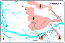
The Yacolt Burn (also known as the Yacolt Fire, the Yacolt Blaze, the Yacolt-Cispus Burn, or the Columbia Fire of 1902) was the result of many weather factors as well as careless humans. The summer of 1902 had been drier than normal and early September winds blowing from west to east. A build-up of slash from loggers had not been burned off properly in the preceding two summers.[4] On September 8 a fire was started by boys trying to burn a nest of yellow jackets near Eagle Creek, Oregon. Other large fires the occurred independently or combined with other fires started soon thereafter, including one started by a locomotive in Dodson, Oregon.[5] Other accounts cite lightning as the genesis of the fire as well as careless campers and berry pickers, hunters, and loggers cutting slash.[3][4] The fire spread rapidly, extending from Bridal Veil, Oregon to Cascade Locks, Oregon before burning debris carried across the Columbia River to Washington. It traveled 30 miles (48 km) in 36 hours and destroyed 238,920 acres (967 km²) of timber, about 12 billion board feet (28,000,000 m³), in Clark, Cowlitz and Skamania counties.
Extent of Damages
The fires ravaged the towns of Vale, Bucoda, and Elma, Washington. Although the fire's namesake is for the town of Yacolt, Washington, that town did not burn in the fires.[1] The loss of all property was assessed at a 1902 value of US$12,767,100.[4] The property damage in Multnomah County, Oregon was estimated at more than one million dollars.[6]
The fire dropped one-half inch of ash in Portland, Oregon. The smoke was so thick that street lights glowed at noon in Seattle 160 miles (258 km) away and ships on the Columbia River were forced to navigate only by compass.[7] Yacolt, Washington was approached by the inferno close enough to blister paint on the town's 15 buildings, but the wind changed, causing the fire to veer north toward the Lewis River, where it burned itself out. At this point an estimated total of 500,000 acres of forest burned in the fire.[8]
Interestingly, the timber industry on the Columbia River garnered 13,590,599 board feet of shipments in October, 1902, setting a new record for production in a single month.[9]
Legislation: Yacolt Burn Rules
Immediate calls for legislation were put into action in Oregon and Washington in order to prevent fires of this scale from breaking out again. Some bills were passed into law, but they were not effective measures. In 1929, the Dole Valley fire destroyed another 153,000 acres (620 km2) of timber. The last major fire was on November 8. 1952. The propensity for the forested uplands in this area to be repeatedly burned is due to the presence of the Columbia River Gorge, which slices through the Cascade Mountains at nearly sea level and makes the climate of the Portland Metropolitan Area relatively immoderate compared to that of Seattle. The area's wet winters cause rapid growth of lush timber, but this is followed by the intrusion of hot, dry weather in the summer from the arid Cascade Mountain rainshadow. As a result, all logging and other commercial activity in the area is regulated by very restrictive "Yacolt Burn Rules."
See also
References
- 1 2 Crutchfield, James (2008). It Happened in Washington. Guilford, CT: TWODOT. pp. 97–100. ISBN 9780762745708.
- ↑ Unknown (June 7, 1931). "Governor Warns of Forest Danger". The Oregonian.
- 1 2 Attwell, Albert (1975). Columbia River Gorge History Volume Two. Stevenson, WA: Tahlkie Books. pp. 202–203.
- 1 2 3 "Oregon and Washington Fires". The Columbia River and Oregon Timberman: 41. December 1902.
- ↑ Carr, Bill (1983). A History of the Bridal Veil Lumbering Company. United States Department of Agriculture, Pacific Northwest Region; Mt. Hood National Forest.
- ↑ Unknown (September 15, 1902). "Flames Make Ashes of Oregon and Washington Homes and One Hundred Lives May Be Death's Grim Record". San Francisco Call.
- ↑ Unknown (September 13, 1902). "Columbia Blazing on Both Sides". The Daily Journal.
- ↑ Attwell, Jim (1975). Columbia River Gorge History, Volume 2. Stevenson, WA: Tahlkie Books. p. 203.
- ↑ The Columbia River and Oregon Timberman. November 1902. Missing or empty
|title=(help)
Sources
- Washington State Department of Natural Resources. Yacolt Burn State Forest Map (notes on reverse), 1991
Coordinates: 45°50′N 122°10′W / 45.833°N 122.167°W
| |||||||
| |||||||
|