Yangiyer
Coordinates: 40°16′N 68°49′E / 40.267°N 68.817°E
| Yangiyer Yangiyer / Янгиер | |
|---|---|
 Yangiyer Location in Uzbekistan | |
| Coordinates: 40°16′N 68°49′E / 40.267°N 68.817°E | |
| Country |
|
| Region | Sirdaryo Region |
| Population (1991) | |
| • Total | 29,600 |
Yangiyer (Uzbek: Yangiyer / Янгиер; Russian: Янгиер) is a city (1991 pop. 29,600) in Sirdaryo Region, Eastern Uzbekistan. It was established in 1957 as part of the grand Soviet project to cultivate the naturally saline virgin lands of Golodnaya Steppe, a vast area of about 10,000 square kilometres in Eastern Uzbekistan. The shortage of irrigation water was the main problem hindering the development of agriculture in the area.
The city has several plants including a plant of building materials (комбинат стройматериалов), pipe plant (гончарно-дренажный завод), asphalt plant (асфальтобетонный).
Yangier also has a branch of Tashkent Institute of Agriculture and Irrigation Engineering (Филиал Ташкентского Института Инженеров Ирригации и Механизации Сельского Хозяйства), a college of civil engineering (коммунально-строительный техникум) and a museum dedicated to cultivation of virgin lands of Golodnaya Steppe (Музей "Освоение Голодной Степи")
External links
Capital: Guliston | ||
| Districts and seats | 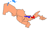 | |
| Other towns | ||