Uchkuduk
| Uchkuduk Uchquduq / Учқудуқ | |
|---|---|
|
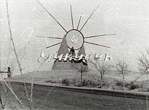
Uchkuduk, 1983 | |
 Uchkuduk Location in Uzbekistan | |
| Coordinates: 42°09′24″N 63°33′20″E / 42.15667°N 63.55556°ECoordinates: 42°09′24″N 63°33′20″E / 42.15667°N 63.55556°E | |
| Country |
|
| Region | Navoiy Region |
| District | Uchkuduk District |
| Elevation | 193 m (633 ft) |
| Population (2011) | |
| • Total | 28,000 |
Uchkuduk (Uzbek: Uchquduq / Учқудуқ; Russian: Учкудук) is a city (pop est 27,000) in the north of Navoiy Region, Uzbekistan. The city's name means "three draw-wells" in Uzbek. It is located at 42°9′24″N 63°33′20″E / 42.15667°N 63.55556°E, at an altitude of 193 meters in the middle of the Kyzyl Kum.
History
Uchkuduk was founded in 1958, after a small prospecting party found deposits of uraniumore. In the late 1960s, the developed of open pit and underground mining led to the rapid growth of the settlement, with workers, engineers and technicians from all over the Societ Union. It was elevated to city status in 1978. Until 1979, Uchkuduk had the status of was a "closed secret city," as it supplied much of the raw material for the nuclear weapons in the Soviet military arsenal. The mining operations are now under the control of the Navoi Mining and Metallurgical Combine (NMMC), which continues to mine and process uranium using in-situ leach processes. The company also produces gold by the same process.
Aeroflot Flight 7425 crashed near Uchkuduk on July 10, 1985.
The Uzbek group Yalla made a Soviet-wide hit named after the city.
References
| Wikimedia Commons has media related to Uchkuduk. |
Capital: Navoiy | ||
| Districts and seats | 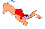 | |
| Other towns | ||