Bolshoy Ussuriysky Island
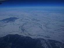
Bolshoi Ussuriysky Island (Russian: о́стров Большо́й Уссури́йский), or Heixiazi Island (simplified Chinese: 黑瞎子岛; traditional Chinese: 黑瞎子島; pinyin: Hēixiāzi Dǎo), is a sedimentary island at the confluence of the Ussuri and Amur rivers. It is divided between the People's Republic of China (PRC) and Russia. It has an area of about 327 to 350 km² and is bounded closely by Yinlong Island (Tarabarov Island), and over ninety islets (in Chinese, Heixiazi may refer only to the large island or to the island group collectively). Its position at the confluence of the Amur and the Ussuri and right next to the major Russian city of Khabarovsk, has given it great strategic importance.
History
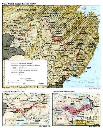
Until 2004, Bolshoy Ussuriyskiy Island was the site of a territorial dispute between China and Russia. The Soviet Union occupied Bolshoy Ussuriyskiy and Yinlong Islands in 1929, but this was not accepted by China. While Russia governed the islands as a part of Khabarovsk Krai, China claimed them as a part of Fuyuan County, Heilongjiang province; the easternmost part of China.
From 1931 to 1945 Bolshoy Ussuriysky was claimed as part of Japan's puppet state of Manchukuo and was known to the Japanese as Kanchazu Island. In June 1937 Bolshoy Ussuriyskiy was briefly occupied by Soviet sailors til they were driven off by Japanese and Manchukuoan troops in the Kanchazu Island incident
The difficulty in settling this dispute involved competing interests between Russia and China. To settle the boundary along the lines claimed by China would have moved settled parts of the city of Khabarovsk into China. However, to grant the island to Russia would have put the boundary along a waterway that is not navigable by large ships restricting Chinese ability to move ships along the Amur.[1]
On October 14, 2004, the Complementary Agreement between the People's Republic of China and the Russian Federation on the Eastern Section of the China-Russia Boundary was signed, in which Russia agreed to relinquish control over Yinlong Island and around half of Bolshoy Ussuriysky. About 170 square kilometres of Bolshoy Ussuriysky was transferred to China, while the rest will remain in Russia's jurisdiction.[2] In return, China agreed to drop all territorial claims to the remainder of Bolshoy Ussuriysky kept by Russia and received the right to navigate ships along the main channel of the Amur.
Geography
The total area of these territories in the Khabarovsk region is approximately 340 square kilometres. The two sections make up less than two per cent of the China–Russia border, which stretches to some 4,300 kilometres and is one of the longest land frontiers on the planet.[3]
The Chinese section of the island is part of Fuyuan County, Heilongjiang. The Russian section is part of Khabarovsky District of Khabarovsk Krai.
Agreement between Russia and People's Republic of China
In 2005, the Russian Duma and the Chinese National People's Congress approved the agreement. On July 21, 2008, an agreement was signed in Beijing by the Chinese and Russian Foreign Ministers, that finalized the border demarcation and formally ended negotiations. Under the agreement, Russia would transfer approximately 174 km² of territory to China.[4] The transfer took place on October 14, 2008.[5] The area being transferred to China is largely uninhabited.[6]
Controversy
The agreement has met with controversy on both sides of the border. In May 2005, Cossacks in Khabarovsk demonstrated against the loss of half of Bolshoy Ussuriysky. In return, some Chinese commentators, especially the media in Hong Kong, Taiwan and overseas which are outside the control of PRC government censorship, criticized the PRC government for signing the agreement, which they regarded as sealing as permanent the loss of former Chinese territory, such as Outer Manchuria, to Russia.
The government of the Republic of China on Taiwan (ROC) has never recognized border treaties signed by the PRC with other countries. Therefore, the ROC still formally claims all parts of the Heixiazi Islands.
According to a 2002 study by Akihiro Iwashita, a Japanese specialist on Slavic relations, “Most of Khabarovsk’s local elites, in particular military, considered the islands of strategic importance since they fenced off Khabarovsk from China. If the border was drawn, relying upon the ‘main channel principle’, the two islands would have passed to China. This is why the Soviet Union insisted on the legal exceptionality of the two islands in its negotiations with China during the late 1980s, while strengthening its de facto control of these islands”.[7]
See also
References
- ↑ ISN Editors. "How the Sino-Russian Boundary Conflict Was Finally Settled: From Nerchinsk 1689 to Vladivostok 2005 via Zhenbao Island 1969". Retrieved 30 October 2014.
- ↑ World's biggest country becomes a little bit smaller - Russia Today, October 2008
- ↑ World's biggest country becomes a little bit smaller - Russia Today, October 2008
- ↑ Business Standard. "Business Standard Article - source for 174 km² figure". Retrieved 30 October 2014.
- ↑ "RIA Novosti". RIA Novosti. Retrieved 30 October 2014.
- ↑ "Economist article including map of new Russia China Border". The Economist. Retrieved 30 October 2014.
- ↑ Russia Today
External links
| ||||||||||
| ||||||||||
Coordinates: 48°21′41″N 134°48′50″E / 48.36139°N 134.81389°E