Yukon River Basin
| Yukon River Basin | |
|---|---|
 The location of the Basin is between Alaska and Yukon Territory | |
| Basin | |
| Main source | Alaska and The Yukon Territory |
| River system | Yukon River |
| Basin size | 330,000 square miles (850,000 km2) |
| Population | 126,000 indigenous peoples |
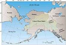
The Yukon river basin is located between the Yukon Territory in Canada and Alaska, with a small portion in British Columbia. This basin is made up of 13 other individual basins which will drain into the Yukon River and other joining rivers and tributaries. Around the mid to late 1800s, the Yukon River Basin was explored by people, such as Leroy McQuesten, and was discovered to have a tremendous amount of useful resources.[1] These resources, including a wide variety of minerals and soils, proved to be very intriguing to explorers, which resulted in the increase of popularity for the Yukon River Basin. The Yukon River Basin's impressive length ranks it the fourth largest basin in North America. It is 330,000 square miles (850,000 km2) in area and 1,980 miles (3,190 km) in length.[1] Many different geological features make up the basin, including several types of terrain, shrubland, and rivers that surround basin.
The Yukon River Basin has a relatively intact ecosystem. The basin is home to a large variety of plants and animals, which all serve as an important and vital contribution to the basin. Many of those who live around or near the basin tend to use both the water and these plants and animals as a means of survival. The Yukon River Basin is a very important and useful resource to those that come in contact with it daily, as well as travelers who may just be passing through. The basin is known for its rich salmon population. Salmon is used as both food for the villagers and a growing industry for the community.
History
Some of the oldest known humans that inhabited North America are said to have lived around the western part of the Yukon Basin. They got here by crossing the land bridge, Beringia. Most of these people lived on their own and didn't receive any type on influence from other cultures for hundreds of years.[1]
The earliest exploration of the Yukon River Basin happened in 1840 by Robert Campbell. Campbell explored different rivers, but also explored the Yukon River Basin and placed an outpost there. Other early explorers like Campbell, came not for gold and riches, but for furs. Once the 1870s hit, explorers like Leroy McQuesten, Arthur Harper, and Alfred Mayo, started realizing how plentiful the Yukon river and Yukon River basin was with minerals. They had put up outposts, just like the earlier explorers, but with their frequent returns in the summer lead them to see these minerals. Their business began growing and spreading. Once their employed miners reached the Stewart River they found gold. From then on, gold was a huge attraction for many people.[1]
Geography
The Yukon River Basin is approximately 330,000 square miles (850,000 km2) in area and 1,980 miles (3,190 km) in length.[1] This makes the Yukon River Basin the fourth largest basin in North America. It is located between the Rocky Mountains in the north and the Pacific Mountain system to the south. The Basin is spread out between Canada in the Yukon Territory and Alaska.[2] The Yukon Flats basin is south of the Yukon River Basin and it drains deposits and reworked materials into the Flats.[3] It is within the Arctic Complex of the Arctic-Atlantic Bioregion, therefore has freshwater.[4]
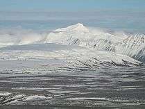
The Yukon River Basin is made up of 13 other individual basins and stretches across two countries, America and Canada. While there are 13 individual basins within the Yukon Basin, there are also 5 physio-graphic regions. The topography of the Basin is very diverse with different elevations, so that is why there are regions. They include, Alaska Range (6,000–9,000 feet or 1,800–2,700 metres), Central and Eastern Brooks Range (7,000–8,000 feet or 2,100–2,400 metres), Indian River Uplands (1,500–2,000 feet or 460–610 metres), Innoko Lowlands (flat flood plains), and Kolkrine-Hodzana Highlands (2,000–4,000 feet or 610–1,220 metres).[1]
Geology
Half of the Yukon River Basin lies in Canada, with the other half occupying space in Alaska. The Yukon River Basin is made up of many different geological terranes, which is why there is a variety of different rocks that make up the basin itself. A few of the many types of rocks includes various types of sedimentary rocks, intrusive rocks, volcanic rocks, and metamorphic rocks[2] There are several different land types that make up the entirety of the Yukon River Basin. These include the needleleaf forest, tall and low shrublands, broadleaf forest, lichens, barren, wet herbaceous, dwarf shrublands, dry herbaceous, ice/snow, and rivers, streams, and lakes. There are also many different types of soils that make up the Yukon River Basin. These soils include Entisols, Gelisols, Inceptisols, Inceptisols/Gelisols, Mollisols, Spodosols, and Rough Mountainous Land.[2]
Permafrost is a major component of the Yukon River Basin. Because of the excessive amount of permafrost in the basin, the basin itself is far more prone to flash floods. The melting of permafrost is believed to be one of the reasons that the Yukon River Basin's flow has increased over the years.[5] On top of increasing the basin's flow, the permafrost is also believed to have had a very active role in the erosion of the basin.[5] On the contrary, however, the flow of the Yukon River Basin tends to slow down during the warmer months.
Hydrology
The hydrology of the Yukon River Basin is very important for many reasons. The water itself and the fish and other animals throughout the basin are used by local citizens for various reasons, which is why it is very important that the quality of the water be checked often and be healthy[6] The water is used for drinking, is a habitat for the fish, and is also used as a means of transportation for many travelers. Water quality varies from site to site throughout the Yukon River Basin, for example the density throughout the eastern and southern sites of the basin is much more prominent than that of the western and northern cites.[2] Because of its northern location, the Yukon River Basin is frozen over for nearly 8 months out of the year.[2]
There are many factors that go into making up the chemical composition of the water in the basin. Many of these factors are simply the uncontrollable natural factors. The Yukon River Basin drains from east to west, with the temperature of the water increasing as the water flows down stream.[7] The streamflow of the Yukon River Basin is not affected by hydropower.[7]
Climate
The climate around the Yukon River Basin varies because of factors like it's topography and large size. This large area covers land from Alaska and from parts of the Yukon Territory in Canada.[6] Due to the variation factors, the climate is calculated by precipitation and temperature.[1]
The precipitation over the entire basin is approximately 19 inches (480 mm) per year. With the diverse topography certain places receive more rain than others. Some areas receive less than 10 inches (250 mm) of rainfall a year and others receive up to 50 inches (1,300 mm). With that being said, annual rainfall is greater on tall, rugged mountains than on flat lowland areas of the whole region.[1]
In recent studies, the temperatures have been steadily rising throughout the region since the 1840s. The average temperature now for the Yukon River Basin is approximately 30 °C (86 °F) in the summer and −40 °C (−40 °F) in the winter.[6] That average is not very accurate, however, because it has some of the most extreme temperature changes for an area that is located in a continental zone.[6][8]
Climate change has been a serious, on-going issue around the Yukon River Basin and other surrounding areas. With drier, hotter temperatures, there have been more natural problems like forest fires and melting permafrost, which leads to changes in water flows.[2]
Climate change
The recent change in climate has also taken a tole on the Yukon River basin. An example of this would be, in 2009 the river experienced extreme flooding.[6] This was due to the above average snow and ice levels followed by and abnormal high spring temperatures.[6] Resulting in the rapid melting of the ice and snow causing the large ice movement down stream.[6] During this time the water levels were extremely high ice choked. The river suffered because of the debris and the erosion along the river. Not only has the climate change affected the Yukon river and the Yukon river basin but, it has also affected the water shed as a whole.[6]
Ecosystems
The Yukon river basin has a relatively intact ecosystem. It is a quality habitat for birds, mammal, fish, invertebrates, and one amphibian.[9] The wood frog is the only amphibian able to survive in the ecosystem.[9] This is due to its increased level of glucose in its cells. This addition acts as an antifreeze. It allows the frogs to survive the extremely cold winters.[9] The basin consists of thousands of lakes, ponds, sloughs, wetlands, and rivers/streams to provide habitats for these animals.[9] Within the basin there are more than 150 bird species, 40 mammals, and 18 fish species.[9] There is an estimated 1.5 million ducks that breed here annually. It is also home to the longest salmon runs in history.[9]
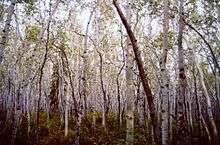
The plant life of the Yukon river basin consists of white spruce, paper birch, and quaking aspen forests, willow and alder thickets, grasslands, and meows. In these areas are where the animals of the ecosystem thrive.[9]
Salmon patterns
The Yukon river basin is home to the longest salmon runs in history. Salmon from this area are prized for their rich oily meat. This is due to the large fat reserves that they must build up in order to make the long journey up the Yukon river.[6] A few examples of these prized salmon would be of the chinook, coho and chum salmon species.[6]
Not only are the salmon prized for their delectable meat but, they are also substance resource for villages in the area.[6] In these areas the salmon are typically dried, smoked, and frozen.[6] They would also serve as a big industry for villages in the area. Without these salmon runs it is possible that the ecosystem of the Yukon river basin may not thrive. So, because of that the fisheries are managed by the Alaska Department of Fish and Game along with other national and international treaties.[6]
Many studies have been done to watch the migratory patterns of the salmon. In one particular study researchers studied the migratory patterns of wild chinook salmon.[10] They did this by capturing and tagging adult chinook salmon from June to mid July in the lower Yukon river.[10] The tagged fish had radio transmitters, which were used to track the salmon and their migration patterns throughout the Yukon river.[10] This data was then used to monitor the salmon in the river system.
| Category (year) | 2002 | 2003 | 2004 | All Years |
|---|---|---|---|---|
| Start of Tagging | 9 June | 3 June | 3 June | 3-9 June |
| End of Tagging | 13 July | 14 July | 19 July | 13-19 July |
| Captured | 1, 310 | 2,312 | 2,107 | 5,729 |
| Tagged | 768 | 1,097 | 995 | 2,860 |
| Moved Up River | 751 | 1,081 | 958 | 2,790 |
| Tracked Past Multiple Stations | 683 | 1,050 | 893 | 2,626 |
| Typical Pattern | 666 | 1,031 | 863 | 2,560 |
This is data regarding Chinook salmon migration in the Yukon river.[10]
Demographics
There are four towns/cities around the Yukon River Basin and 43 villages. Within those towns,cities, and villages, approximately 126,000 people are currently living there. Out of the 126,000 people living there, ten percent still rely solely on the land and 83 percent are indigenous.[9] In the towns of Dawson and Faro, there are 1,000-2,000 residents. The city Whitehorse has over 23,000 residents, while Fairbanks had around 84,000 residents. Villages around the basin are holding anywhere from 30 to 800 people.[1]
See also
References
- 1 2 3 4 5 6 7 8 9 "Environmental and Hydrologic Overview of the Yukon River Basin, Alaska and Canada". Water Resources investigation report. 99-4204.
- 1 2 3 4 5 6 Water-supply Paper. U.S. Government Printing Office. 1915-01-01.
- ↑ Geological Survey Bulletin. U.S. Department of the Interior, Geological Survey; Washington, D.C. 1949-01-01.
- ↑ Benke, Arthur C.; Cushing, Colbert E. (2011-09-06). Rivers of North America. Academic Press. ISBN 9780080454184.
- 1 2 Wilson, Nicole J.; Walter, M. Todd; Waterhouse, Jon (2015-02-23). "Indigenous Knowledge of Hydrologic Change in the Yukon River Basin: A Case Study of Ruby, Alaska". ARCTIC. 68 (1): 93–106. doi:10.14430/arctic4459. ISSN 1923-1245.
- 1 2 3 4 5 6 7 8 9 10 11 12 13 "Yukon River Condition Summary" (PDF). August 2012. Retrieved 15 November 2016.
- 1 2 "Increased groundwater to stream discharge from permafrost thawing in the Yukon River basin: Potential impacts on lateral export of carbon and nitrogen". GEOPHYSICAL RESEARCH LETTERS. 34.
- ↑ "USGS". USGS. March 2010.
- 1 2 3 4 5 6 7 8 "Yukon River Condition Summary" (PDF). August 2012. Retrieved 15 November 2016.
- 1 2 3 4 Eiler, J. H., Evans, A. N., & Schreck, C. B. (2015). Migratory Patterns of Wild Chinook Salmon Oncorhynchus tshawytscha Returning to a Large, Free-Flowing River Basin. Plos ONE, 10(4), 1-33. doi:10.1371/journal.pone.0123127